Grays River Topo Map Washington
To zoom in, hover over the map of Grays River
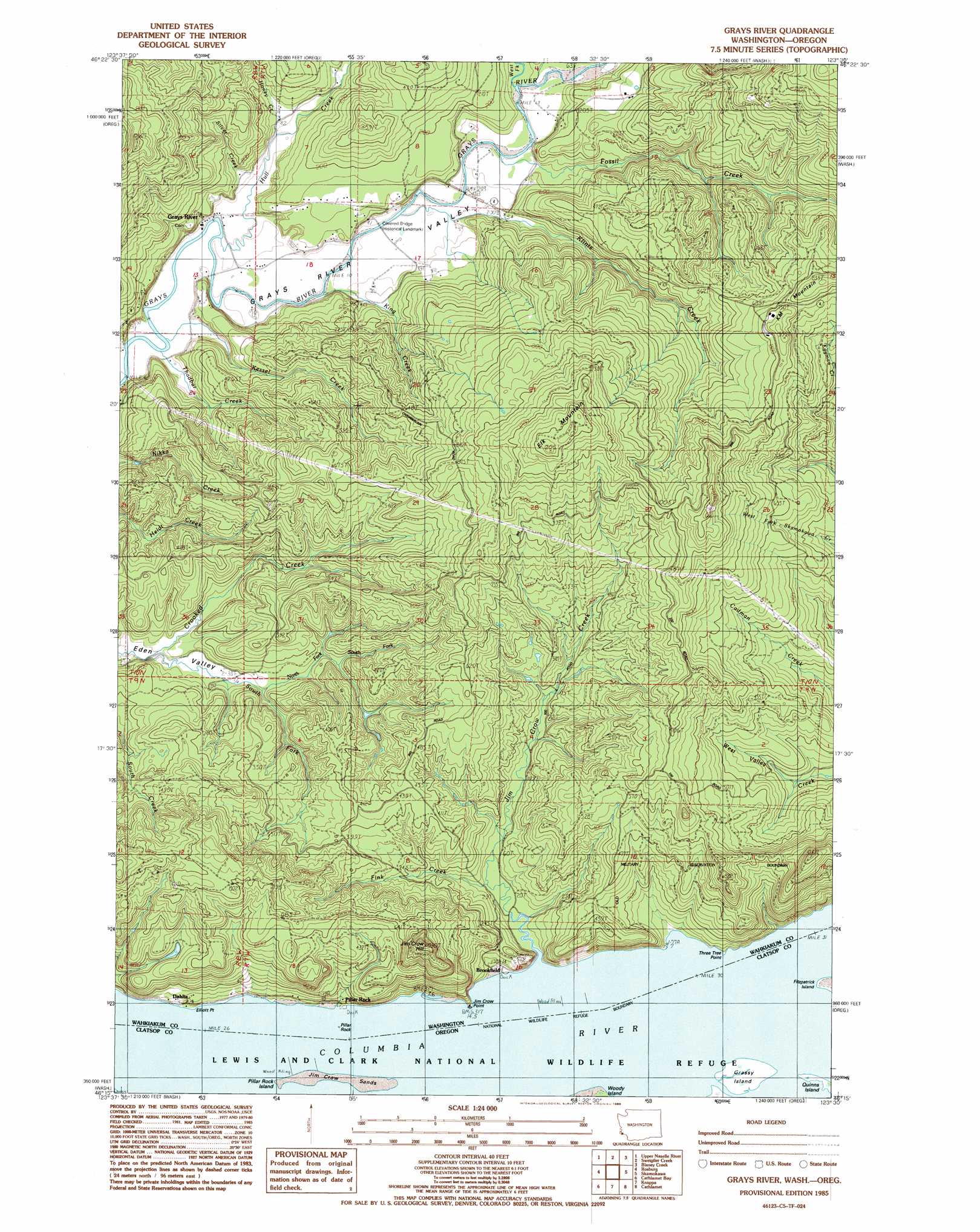
USGS Topo Quad 46123c5 - 1:24,000 scale
| Topo Map Name: | Grays River |
| USGS Topo Quad ID: | 46123c5 |
| Print Size: | ca. 21 1/4" wide x 27" high |
| Southeast Coordinates: | 46.25° N latitude / 123.5° W longitude |
| Map Center Coordinates: | 46.3125° N latitude / 123.5625° W longitude |
| U.S. States: | WA, OR |
| Filename: | o46123c5.jpg |
| Download Map JPG Image: | Grays River topo map 1:24,000 scale |
| Map Type: | Topographic |
| Topo Series: | 7.5´ |
| Map Scale: | 1:24,000 |
| Source of Map Images: | United States Geological Survey (USGS) |
| Alternate Map Versions: |
Grays River WA 1985, updated 1986 Download PDF Buy paper map Grays River WA 2011 Download PDF Buy paper map Grays River WA 2013 Download PDF Buy paper map |
1:24,000 Topo Quads surrounding Grays River
North Nemah |
Menlo |
Lebam |
Pluvius |
Pe Ell |
Oman Ranch |
Upper Naselle River |
Sweigiler Creek |
Blaney Creek |
Elochoman Pass |
Knappton |
Rosburg |
Grays River |
Skamokawa |
Skamokawa Pass |
Astoria |
Cathlamet Bay |
Knappa |
Cathlamet |
Nassa Point |
Olney |
Green Mountain |
Wickiup Mountain |
Nicolai Mountain |
Marshland |
> Back to 46123a1 at 1:100,000 scale
> Back to 46122a1 at 1:250,000 scale
> Back to U.S. Topo Maps home
Grays River topo map: Gazetteer
Grays River: Capes
Elliott Point elevation 5m 16′Jim Crow Point elevation 34m 111′
Three Tree Point elevation 16m 52′
Grays River: Channels
Pillar Rock Lower Range elevation 0m 0′Pillar Rock Lower Range elevation 0m 0′
Pillar Rock Lower Range elevation 0m 0′
Pillar Rock Upper Range elevation 0m 0′
Pillar Rock Upper Range elevation 0m 0′
Pillar Rock Upper Range elevation 0m 0′
Welch Island Reach elevation 0m 0′
Welch Island Reach elevation 0m 0′
Grays River: Dams
Pillar Rock Dam Number One elevation 75m 246′Pillar Rock Dam Number Two elevation 75m 246′
Grays River: Islands
Grassy Island elevation 2m 6′Pillar Rock Island elevation 0m 0′
Grays River: Pillars
Pillar Rock elevation 0m 0′Grays River: Populated Places
Brookfield elevation 8m 26′Dahlia elevation 30m 98′
Grays River elevation 5m 16′
Grays River: Streams
Fall Creek elevation 18m 59′Fink Creek elevation 7m 22′
Fossil Creek elevation 12m 39′
Honey Creek elevation 8m 26′
Hull Creek elevation 4m 13′
Jim Crow Creek elevation 15m 49′
Kessel Creek elevation 2m 6′
King Creek elevation 4m 13′
Klints Creek elevation 10m 32′
North Fork South Fork Crooked Creek elevation 24m 78′
Silver Creek elevation 7m 22′
South Fork Crooked Creek elevation 13m 42′
Thadbar Creek elevation 3m 9′
West Fork Grays River elevation 13m 42′
Grays River: Summits
Elk Mountain elevation 452m 1482′Jim Crow Hill elevation 321m 1053′
KM Mountain elevation 275m 902′
Grays River digital topo map on disk
Buy this Grays River topo map showing relief, roads, GPS coordinates and other geographical features, as a high-resolution digital map file on DVD: