Wildwood Topo Map Washington
To zoom in, hover over the map of Wildwood
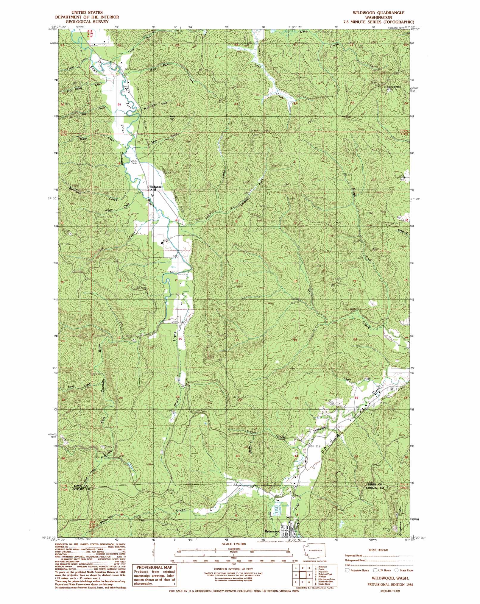
USGS Topo Quad 46123d1 - 1:24,000 scale
| Topo Map Name: | Wildwood |
| USGS Topo Quad ID: | 46123d1 |
| Print Size: | ca. 21 1/4" wide x 27" high |
| Southeast Coordinates: | 46.375° N latitude / 123° W longitude |
| Map Center Coordinates: | 46.4375° N latitude / 123.0625° W longitude |
| U.S. State: | WA |
| Filename: | o46123d1.jpg |
| Download Map JPG Image: | Wildwood topo map 1:24,000 scale |
| Map Type: | Topographic |
| Topo Series: | 7.5´ |
| Map Scale: | 1:24,000 |
| Source of Map Images: | United States Geological Survey (USGS) |
| Alternate Map Versions: |
Wildwood WA 1986, updated 1986 Download PDF Buy paper map Wildwood WA 2011 Download PDF Buy paper map Wildwood WA 2013 Download PDF Buy paper map |
1:24,000 Topo Quads surrounding Wildwood
Doty |
Rainbow Falls |
Adna |
Centralia |
Logan Hill |
Pe Ell |
Boistfort |
Curtis |
Napavine |
Jackson Prairie |
Elochoman Pass |
Boistfort Peak |
Wildwood |
Winlock |
Toledo |
Skamokawa Pass |
Elochoman Lake |
Abernathy Mountain |
Castle Rock |
Silver Lake |
Nassa Point |
Oak Point |
Coal Creek |
Kelso |
Mount Brynion |
> Back to 46123a1 at 1:100,000 scale
> Back to 46122a1 at 1:250,000 scale
> Back to U.S. Topo Maps home
Wildwood topo map: Gazetteer
Wildwood: Flats
Cougar Flat elevation 55m 180′Wildwood: Populated Places
Ryderwood elevation 80m 262′Wildwood elevation 104m 341′
Wildwood: Streams
Banks Creek elevation 73m 239′Becker Creek elevation 64m 209′
Black Creek elevation 111m 364′
Bull Pen Creek elevation 100m 328′
Campbell Creek elevation 62m 203′
Cedar Creek elevation 105m 344′
Deer Creek elevation 167m 547′
Foster Creek elevation 95m 311′
Hogan Creek elevation 49m 160′
Laughlin Creek elevation 122m 400′
Lentz Creek elevation 99m 324′
Newland Creek elevation 107m 351′
North Fork Brim Creek elevation 59m 193′
Owens Creek elevation 59m 193′
Point Hill Creek elevation 110m 360′
Root House Creek elevation 99m 324′
Sears Creek elevation 103m 337′
Sep Creek elevation 106m 347′
Slide Creek elevation 99m 324′
Trout Creek elevation 146m 479′
Water Creek elevation 102m 334′
Wilson Creek elevation 107m 351′
Wildwood: Summits
Point Hill elevation 221m 725′Stony Grade elevation 308m 1010′
Wildwood digital topo map on disk
Buy this Wildwood topo map showing relief, roads, GPS coordinates and other geographical features, as a high-resolution digital map file on DVD: