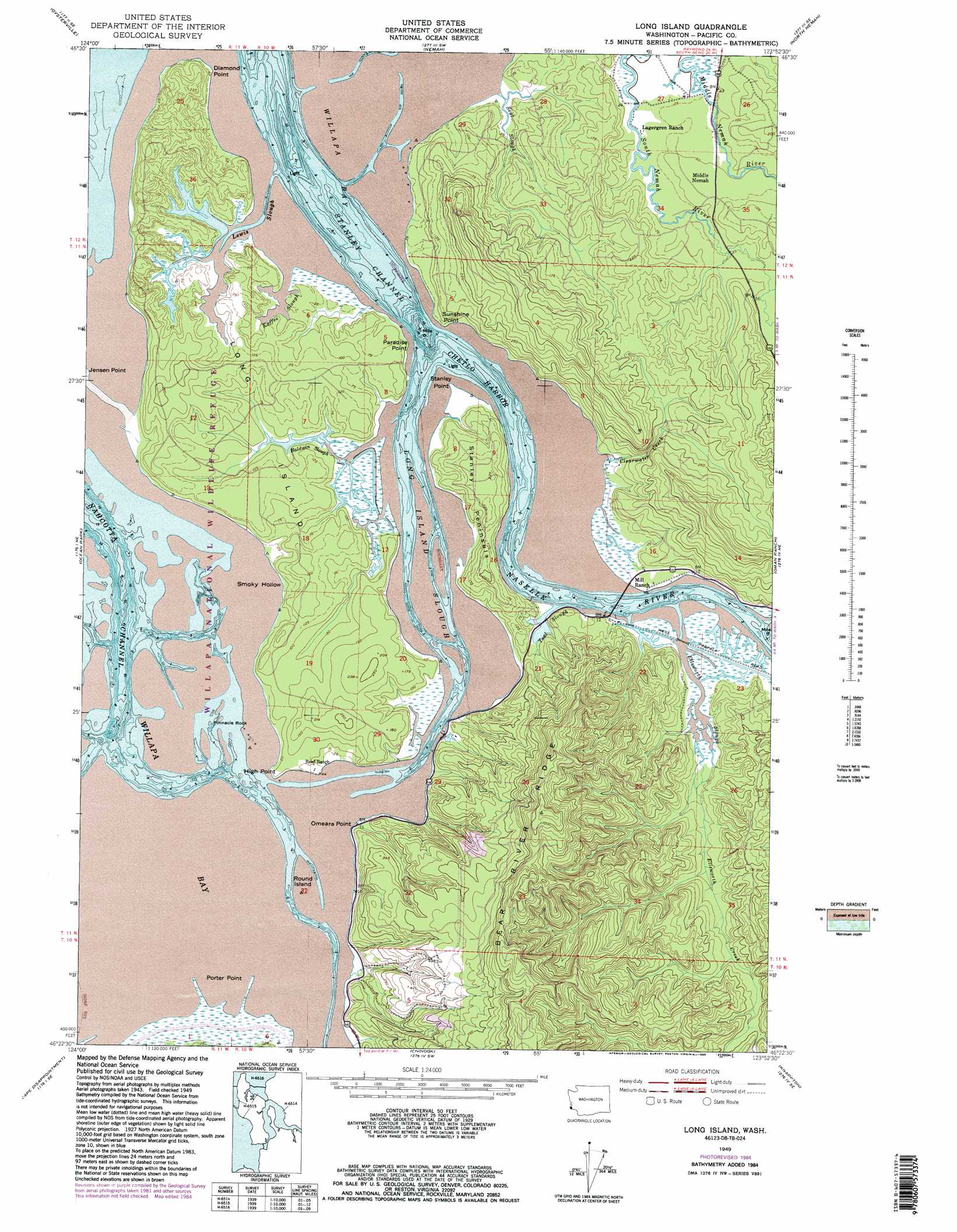
Long Island Topo Map Washington
To zoom in, hover over the map of Long Island
USGS Topo Quad 46123d8 - 1:24,000 scale
| Topo Map Name: | Long Island |
| USGS Topo Quad ID: | 46123d8 |
| Print Size: | ca. 21 1/4" wide x 27" high |
| Southeast Coordinates: | 46.375° N latitude / 123.875° W longitude |
| Map Center Coordinates: | 46.4375° N latitude / 123.9375° W longitude |
| U.S. State: | WA |
| Filename: | o46123d8.jpg |
| Download Map JPG Image: | Long Island topo map 1:24,000 scale |
| Map Type: | Topographic |
| Topo Series: | 7.5´ |
| Map Scale: | 1:24,000 |
| Source of Map Images: | United States Geological Survey (USGS) |
| Alternate Map Versions: |
Long Island WA 1949, updated 1955 Download PDF Buy paper map Long Island WA 1949, updated 1971 Download PDF Buy paper map Long Island WA 1949, updated 1985 Download PDF Buy paper map Long Island WA 2011 Download PDF Buy paper map Long Island WA 2014 Download PDF Buy paper map |
1:24,000 Topo Quads surrounding Long Island
North Cove |
Bay Center |
South Bend |
Raymond |
|
Oysterville |
Nemah |
North Nemah |
Menlo |
|
Ocean Park |
Long Island |
Oman Ranch |
Upper Naselle River |
|
Cape Disappointment |
Chinook |
Knappton |
Rosburg |
|
Clatsop Spit |
Warrenton |
Astoria |
Cathlamet Bay |
> Back to 46123a1 at 1:100,000 scale
> Back to 46122a1 at 1:250,000 scale
> Back to U.S. Topo Maps home
Long Island topo map: Gazetteer
Long Island: Bays
Chetlo Harbor elevation 0m 0′Smoky Hollow elevation 0m 0′
Long Island: Capes
Diamond Point elevation 33m 108′High Point elevation 17m 55′
O'Meara Point elevation 31m 101′
Paradise Point elevation 0m 0′
Porter Point elevation 9m 29′
Stanley Peninsula elevation 69m 226′
Stanley Point elevation 15m 49′
Sunshine Point elevation 20m 65′
Long Island: Dams
Refuge Display Pool Dam elevation 0m 0′Long Island: Islands
Long Island elevation 15m 49′Louse Rocks elevation 0m 0′
Round Island elevation 0m 0′
Long Island: Pillars
Pinnacle Rock elevation 0m 0′Long Island: Populated Places
Middle Nemah elevation 21m 68′Long Island: Streams
Baldwin Slough elevation 0m 0′Clearwater Creek elevation 16m 52′
Ellsworth Creek elevation 0m 0′
Ellsworth Slough elevation 0m 0′
Kaffee Slough elevation 0m 0′
Lewis Slough elevation 0m 0′
Long Island Slough elevation 0m 0′
Naselle River elevation 0m 0′
Seal Slough elevation 11m 36′
Teal Slough elevation 0m 0′
Long Island digital topo map on disk
Buy this Long Island topo map showing relief, roads, GPS coordinates and other geographical features, as a high-resolution digital map file on DVD: