Pe Ell Topo Map Washington
To zoom in, hover over the map of Pe Ell
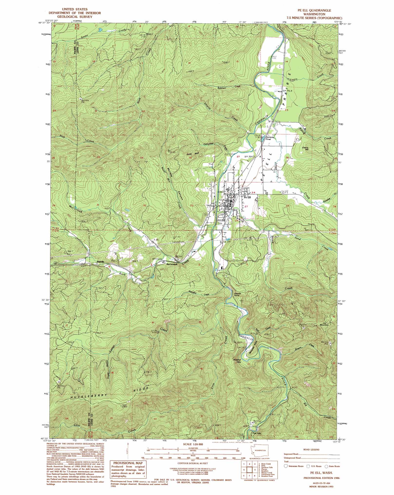
USGS Topo Quad 46123e3 - 1:24,000 scale
| Topo Map Name: | Pe Ell |
| USGS Topo Quad ID: | 46123e3 |
| Print Size: | ca. 21 1/4" wide x 27" high |
| Southeast Coordinates: | 46.5° N latitude / 123.25° W longitude |
| Map Center Coordinates: | 46.5625° N latitude / 123.3125° W longitude |
| U.S. State: | WA |
| Filename: | o46123e3.jpg |
| Download Map JPG Image: | Pe Ell topo map 1:24,000 scale |
| Map Type: | Topographic |
| Topo Series: | 7.5´ |
| Map Scale: | 1:24,000 |
| Source of Map Images: | United States Geological Survey (USGS) |
| Alternate Map Versions: |
Pe Ell WA 1986, updated 1986 Download PDF Buy paper map Pe Ell WA 1986, updated 1994 Download PDF Buy paper map Pe Ell WA 2011 Download PDF Buy paper map Pe Ell WA 2013 Download PDF Buy paper map |
1:24,000 Topo Quads surrounding Pe Ell
Brooklyn |
Blue Mountain |
Cedarville |
Oakville |
Rochester |
East Of Raymond |
Dean Creek |
Doty |
Rainbow Falls |
Adna |
Lebam |
Pluvius |
Pe Ell |
Boistfort |
Curtis |
Sweigiler Creek |
Blaney Creek |
Elochoman Pass |
Boistfort Peak |
Wildwood |
Grays River |
Skamokawa |
Skamokawa Pass |
Elochoman Lake |
Abernathy Mountain |
> Back to 46123e1 at 1:100,000 scale
> Back to 46122a1 at 1:250,000 scale
> Back to U.S. Topo Maps home
Pe Ell topo map: Gazetteer
Pe Ell: Bends
Murphys Hole elevation 162m 531′Pe Ell: Cliffs
Charlies Hump elevation 145m 475′Jones Bluff elevation 260m 853′
Murphys Point elevation 169m 554′
Pe Ell: Dams
Lester Creek Reservoir Dam elevation 279m 915′Pe Ell: Falls
Fisk Falls elevation 183m 600′Pe Ell: Flats
Pe Ell Prairie elevation 116m 380′Pe Ell: Lakes
Helmicks Pond elevation 113m 370′Pe Ell: Populated Places
McCormick elevation 138m 452′Pe Ell elevation 128m 419′
Reynolds (historical) elevation 165m 541′
Walville elevation 182m 597′
Pe Ell: Reservoirs
Lester Creek Reservoir elevation 279m 915′Pe Ell: Ridges
Huckleberry Ridge elevation 724m 2375′Pe Ell: Streams
Big Creek elevation 169m 554′Browns Creek elevation 159m 521′
Cannonball Creek elevation 110m 360′
Crim Creek elevation 134m 439′
Fronia Creek elevation 118m 387′
Hull Creek elevation 146m 479′
Jones Creek elevation 104m 341′
Katula Creek elevation 111m 364′
Kowalski Creek elevation 131m 429′
Lester Creek elevation 156m 511′
Mahaffey Creek elevation 136m 446′
McCormick Creek elevation 140m 459′
Robinson Creek elevation 99m 324′
Rock Creek elevation 123m 403′
Roger Creek elevation 183m 600′
Sand Creek elevation 141m 462′
Shields Creek elevation 110m 360′
Stowe Creek elevation 110m 360′
Water Mill Creek elevation 124m 406′
Pe Ell: Summits
Cherry Hill elevation 225m 738′Joy Mountain elevation 536m 1758′
Pe Ell: Valleys
Cougar Canyon elevation 404m 1325′Mullers Canyon elevation 130m 426′
Pe Ell digital topo map on disk
Buy this Pe Ell topo map showing relief, roads, GPS coordinates and other geographical features, as a high-resolution digital map file on DVD: