Little Rock Topo Map Washington
To zoom in, hover over the map of Little Rock
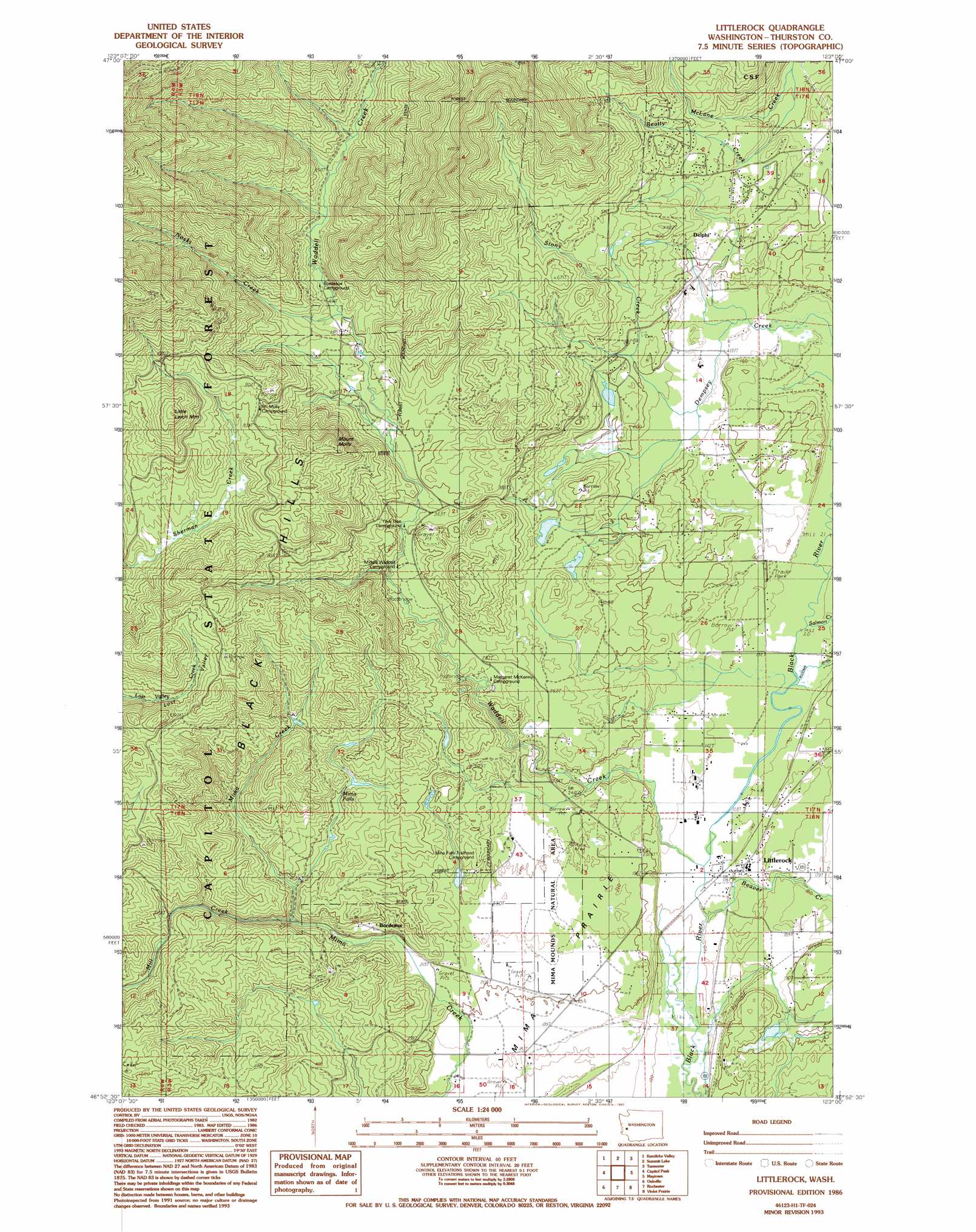
USGS Topo Quad 46123h1 - 1:24,000 scale
| Topo Map Name: | Little Rock |
| USGS Topo Quad ID: | 46123h1 |
| Print Size: | ca. 21 1/4" wide x 27" high |
| Southeast Coordinates: | 46.875° N latitude / 123° W longitude |
| Map Center Coordinates: | 46.9375° N latitude / 123.0625° W longitude |
| U.S. State: | WA |
| Filename: | o46123h1.jpg |
| Download Map JPG Image: | Little Rock topo map 1:24,000 scale |
| Map Type: | Topographic |
| Topo Series: | 7.5´ |
| Map Scale: | 1:24,000 |
| Source of Map Images: | United States Geological Survey (USGS) |
| Alternate Map Versions: |
Littlerock WA 1986, updated 1986 Download PDF Buy paper map Littlerock WA 1986, updated 1993 Download PDF Buy paper map Littlerock WA 2011 Download PDF Buy paper map Littlerock WA 2013 Download PDF Buy paper map |
1:24,000 Topo Quads surrounding Little Rock
Nahwatzel Lake |
Shelton Valley |
Shelton |
Squaxin Island |
Longbranch |
Mccleary |
Kamilche Valley |
Summit Lake |
Olympia |
Lacey |
Malone |
Capitol Peak |
Little Rock |
Maytown |
East Olympia |
Cedarville |
Oakville |
Rochester |
Violet Prairie |
Bucoda |
Doty |
Rainbow Falls |
Adna |
Centralia |
Logan Hill |
> Back to 46123e1 at 1:100,000 scale
> Back to 46122a1 at 1:250,000 scale
> Back to U.S. Topo Maps home
Little Rock topo map: Gazetteer
Little Rock: Airports
Bade Rotor and Wing Service Heliport elevation 41m 134′Little Rock: Canals
Blooms Ditch elevation 40m 131′Little Rock: Dams
Walentiny Dam elevation 51m 167′Little Rock: Falls
Mima Falls elevation 120m 393′Little Rock: Flats
Mima Prairie elevation 64m 209′Little Rock: Parks
Mima Mounds Natural Area elevation 70m 229′Little Rock: Populated Places
Bordeaux elevation 76m 249′Delphi elevation 66m 216′
Littlerock elevation 44m 144′
Little Rock: Streams
Beatty Creek elevation 112m 367′Beaver Creek elevation 38m 124′
Darlin Creek elevation 46m 150′
Mill Creek elevation 98m 321′
Noski Creek elevation 136m 446′
Salmon Creek elevation 43m 141′
Stony Creek elevation 50m 164′
Waddell Creek elevation 40m 131′
Little Rock: Summits
Little Larch Mountain elevation 349m 1145′Mount Molly elevation 358m 1174′
Little Rock digital topo map on disk
Buy this Little Rock topo map showing relief, roads, GPS coordinates and other geographical features, as a high-resolution digital map file on DVD: