Capitol Peak Topo Map Washington
To zoom in, hover over the map of Capitol Peak
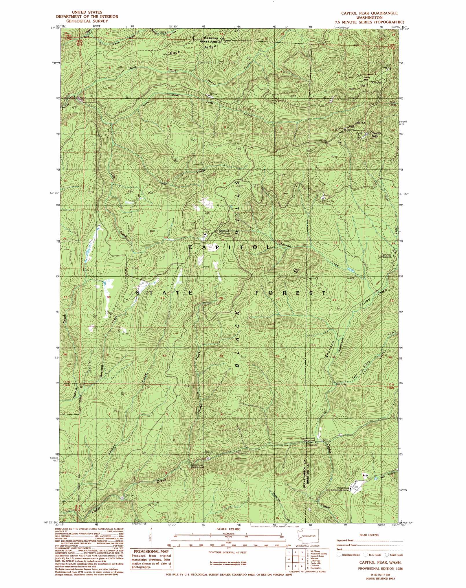
USGS Topo Quad 46123h2 - 1:24,000 scale
| Topo Map Name: | Capitol Peak |
| USGS Topo Quad ID: | 46123h2 |
| Print Size: | ca. 21 1/4" wide x 27" high |
| Southeast Coordinates: | 46.875° N latitude / 123.125° W longitude |
| Map Center Coordinates: | 46.9375° N latitude / 123.1875° W longitude |
| U.S. State: | WA |
| Filename: | o46123h2.jpg |
| Download Map JPG Image: | Capitol Peak topo map 1:24,000 scale |
| Map Type: | Topographic |
| Topo Series: | 7.5´ |
| Map Scale: | 1:24,000 |
| Source of Map Images: | United States Geological Survey (USGS) |
| Alternate Map Versions: |
Capitol Peak WA 1986, updated 1986 Download PDF Buy paper map Capitol Peak WA 1986, updated 1993 Download PDF Buy paper map Capitol Peak WA 2011 Download PDF Buy paper map Capitol Peak WA 2013 Download PDF Buy paper map |
1:24,000 Topo Quads surrounding Capitol Peak
Matlock |
Nahwatzel Lake |
Shelton Valley |
Shelton |
Squaxin Island |
Elma |
Mccleary |
Kamilche Valley |
Summit Lake |
Olympia |
South Elma |
Malone |
Capitol Peak |
Little Rock |
Maytown |
Blue Mountain |
Cedarville |
Oakville |
Rochester |
Violet Prairie |
Dean Creek |
Doty |
Rainbow Falls |
Adna |
Centralia |
> Back to 46123e1 at 1:100,000 scale
> Back to 46122a1 at 1:250,000 scale
> Back to U.S. Topo Maps home
Capitol Peak topo map: Gazetteer
Capitol Peak: Forests
Capitol State Forest elevation 444m 1456′Capitol Peak: Ranges
Black Hills elevation 775m 2542′Capitol Peak: Ridges
Buck Ridge elevation 474m 1555′Capitol Peak: Streams
Bozy Creek elevation 149m 488′Fall Creek elevation 199m 652′
Hell Creek elevation 157m 515′
Iron Creek elevation 195m 639′
Lost Valley Creek elevation 138m 452′
Monroe Creek elevation 182m 597′
North Creek elevation 85m 278′
North Fork Porter Creek elevation 106m 347′
Sherman Creek elevation 119m 390′
South Fork Porter Creek elevation 105m 344′
Swan Creek elevation 209m 685′
Thurston Creek elevation 98m 321′
Capitol Peak: Summits
Capitol Peak elevation 789m 2588′Fuzzy Top elevation 481m 1578′
Larch Mountain elevation 775m 2542′
Capitol Peak: Trails
North Creek Truck Trail elevation 428m 1404′Porter Creek Truck Trail elevation 514m 1686′
Capitol Peak: Valleys
Lost Valley elevation 157m 515′Sherman Valley elevation 190m 623′
Capitol Peak digital topo map on disk
Buy this Capitol Peak topo map showing relief, roads, GPS coordinates and other geographical features, as a high-resolution digital map file on DVD: