Saint John Topo Map Maine
To zoom in, hover over the map of Saint John
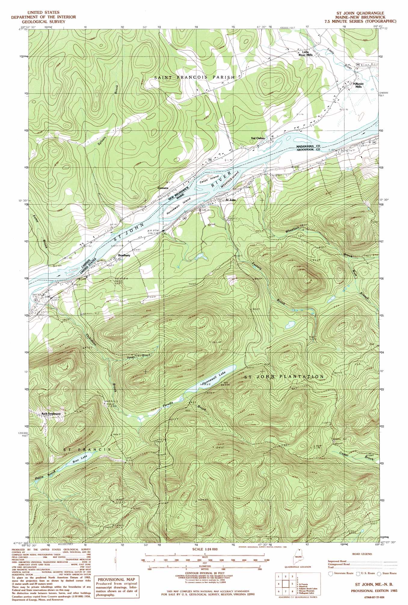
USGS Topo Quad 47068b7 - 1:24,000 scale
| Topo Map Name: | Saint John |
| USGS Topo Quad ID: | 47068b7 |
| Print Size: | ca. 21 1/4" wide x 27" high |
| Southeast Coordinates: | 47.125° N latitude / 68.75° W longitude |
| Map Center Coordinates: | 47.1875° N latitude / 68.8125° W longitude |
| U.S. State: | ME |
| Filename: | o47068b7.jpg |
| Download Map JPG Image: | Saint John topo map 1:24,000 scale |
| Map Type: | Topographic |
| Topo Series: | 7.5´ |
| Map Scale: | 1:24,000 |
| Source of Map Images: | United States Geological Survey (USGS) |
| Alternate Map Versions: |
St Francis NE ME 1975, updated 1981 Download PDF Buy paper map St John ME 1985, updated 1986 Download PDF Buy paper map Saint John ME 2011 Download PDF Buy paper map Saint John ME 2014 Download PDF Buy paper map |
1:24,000 Topo Quads surrounding Saint John
Landry |
||||
Beau Lake |
Fort Kent North |
|||
Falls Brook Lake |
Saint Francis |
Saint John |
Wheelock |
Fort Kent South |
Allagash |
Second Lake |
Mclean Mountain |
Wallacrass Lakes |
Eagle Lake |
Mckeen Lake |
Gardner Pond |
Deboullie Pond |
Island Pond |
Winterville |
> Back to 47068a1 at 1:100,000 scale
> Back to 47068a1 at 1:250,000 scale
> Back to U.S. Topo Maps home
Saint John topo map: Gazetteer
Saint John: Dams
Hunnewell Lake Dam elevation 282m 925′Saint John: Islands
Caton Island elevation 165m 541′Hunnewell Island elevation 166m 544′
Wheelock Island elevation 164m 538′
Saint John: Lakes
Bran Lake elevation 300m 984′Saint John: Populated Places
Back Settlement elevation 330m 1082′Bradbury elevation 171m 561′
Saint John elevation 173m 567′
Saint John: Reservoirs
Hunnewell Lake elevation 282m 925′Saint John: Streams
Factory Brook elevation 160m 524′Jones Brook elevation 237m 777′
Jones Brook elevation 239m 784′
Kelly Brook elevation 159m 521′
Thibideau Brook elevation 161m 528′
West Branch Wheelock Brook elevation 229m 751′
Wheelock Brook elevation 159m 521′
Saint John digital topo map on disk
Buy this Saint John topo map showing relief, roads, GPS coordinates and other geographical features, as a high-resolution digital map file on DVD:
Maine, New Hampshire, Rhode Island & Eastern Massachusetts
Buy digital topo maps: Maine, New Hampshire, Rhode Island & Eastern Massachusetts