Madawaska Topo Map Maine
To zoom in, hover over the map of Madawaska
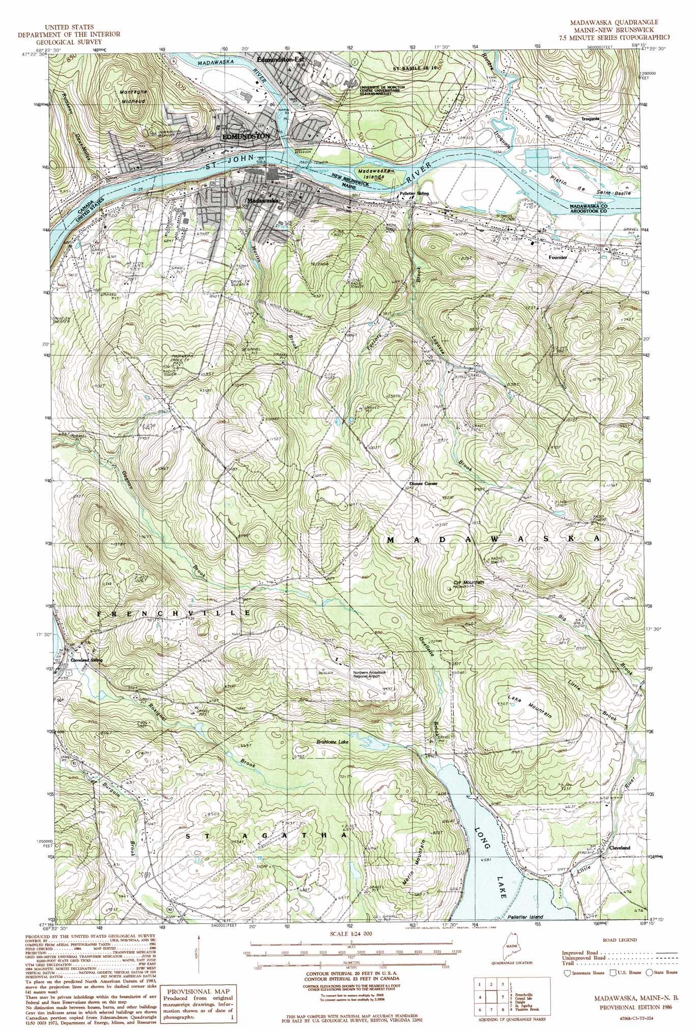
USGS Topo Quad 47068c3 - 1:24,000 scale
| Topo Map Name: | Madawaska |
| USGS Topo Quad ID: | 47068c3 |
| Print Size: | ca. 21 1/4" wide x 27" high |
| Southeast Coordinates: | 47.25° N latitude / 68.25° W longitude |
| Map Center Coordinates: | 47.3125° N latitude / 68.3125° W longitude |
| U.S. State: | ME |
| Filename: | o47068c3.jpg |
| Download Map JPG Image: | Madawaska topo map 1:24,000 scale |
| Map Type: | Topographic |
| Topo Series: | 7.5´ |
| Map Scale: | 1:24,000 |
| Source of Map Images: | United States Geological Survey (USGS) |
| Alternate Map Versions: |
Frenchville SE ME 1975, updated 1981 Download PDF Buy paper map Madawaska ME 1986, updated 1986 Download PDF Buy paper map Madawaska ME 2011 Download PDF Buy paper map Madawaska ME 2014 Download PDF Buy paper map |
1:24,000 Topo Quads surrounding Madawaska
Fort Kent North |
Frenchville |
Madawaska |
Grand Isle |
Lille |
Fort Kent South |
Daigle |
Saint Agatha |
Paulette Brook |
Violette Stream |
Eagle Lake |
Square Lake West |
Square Lake East |
Stockholm |
Picard Brook |
> Back to 47068a1 at 1:100,000 scale
> Back to 47068a1 at 1:250,000 scale
> Back to U.S. Topo Maps home
Madawaska topo map: Gazetteer
Madawaska: Airports
Northern Aroostook Regional Airport elevation 299m 980′Madawaska: Lakes
Brishlotte Lake elevation 189m 620′Madawaska: Populated Places
Cleveland elevation 184m 603′Fournier elevation 154m 505′
Madawaska elevation 175m 574′
Madawaska: Post Offices
Madawaska Post Office elevation 158m 518′Madawaska: Streams
Albert Brook elevation 134m 439′Big Brook elevation 194m 636′
Factory Brook elevation 134m 439′
Lagasse Brook elevation 210m 688′
Little Brook elevation 207m 679′
Little River elevation 178m 583′
Martin Brook elevation 134m 439′
Ouellette Brook elevation 177m 580′
Rosignal Brook elevation 143m 469′
Madawaska: Summits
Cyr Mountain elevation 353m 1158′Lake Mountain elevation 286m 938′
Morin Mountain elevation 268m 879′
Madawaska digital topo map on disk
Buy this Madawaska topo map showing relief, roads, GPS coordinates and other geographical features, as a high-resolution digital map file on DVD:
Maine, New Hampshire, Rhode Island & Eastern Massachusetts
Buy digital topo maps: Maine, New Hampshire, Rhode Island & Eastern Massachusetts