Allagash Topo Map Maine
To zoom in, hover over the map of Allagash
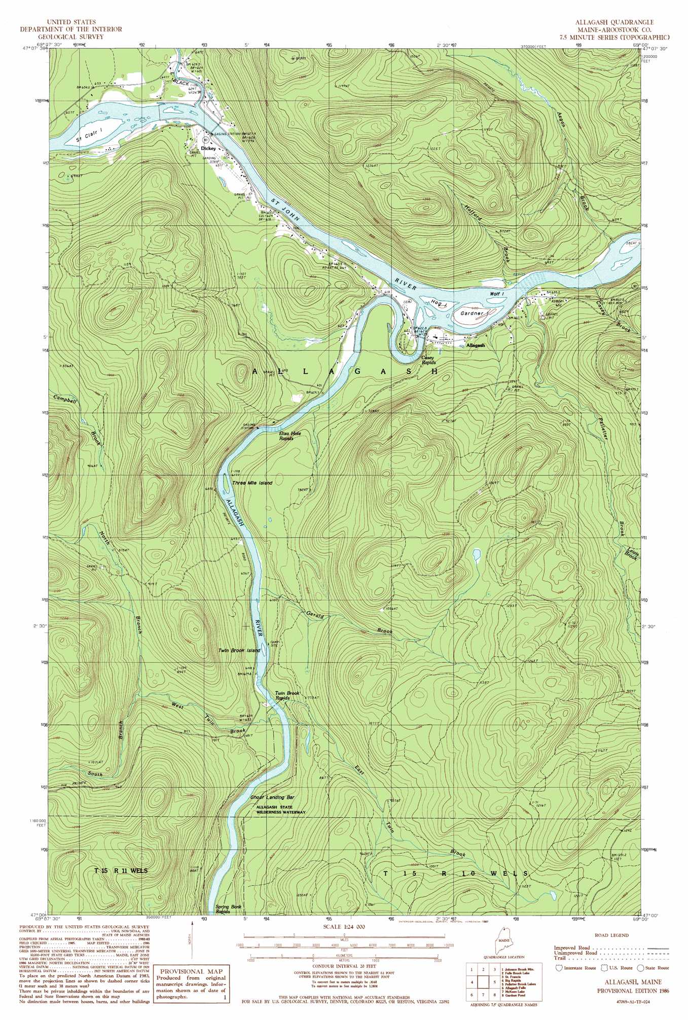
USGS Topo Quad 47069a1 - 1:24,000 scale
| Topo Map Name: | Allagash |
| USGS Topo Quad ID: | 47069a1 |
| Print Size: | ca. 21 1/4" wide x 27" high |
| Southeast Coordinates: | 47° N latitude / 69° W longitude |
| Map Center Coordinates: | 47.0625° N latitude / 69.0625° W longitude |
| U.S. State: | ME |
| Filename: | o47069a1.jpg |
| Download Map JPG Image: | Allagash topo map 1:24,000 scale |
| Map Type: | Topographic |
| Topo Series: | 7.5´ |
| Map Scale: | 1:24,000 |
| Source of Map Images: | United States Geological Survey (USGS) |
| Alternate Map Versions: |
Allagash ME 1986, updated 1987 Download PDF Buy paper map Allagash ME 2011 Download PDF Buy paper map Allagash ME 2014 Download PDF Buy paper map |
1:24,000 Topo Quads surrounding Allagash
Rocky Brook |
Hafey Pond |
Beau Lake |
||
Rocky Mountain |
Johnson Brook Mountain |
Falls Brook Lake |
Saint Francis |
Saint John |
Schoolhouse Rapids |
Big Rapids |
Allagash |
Second Lake |
Mclean Mountain |
Mckinnon Brook |
Allagash Falls |
Mckeen Lake |
Gardner Pond |
Deboullie Pond |
Round Pond |
Five Finger Brook |
Big Brook Lake |
Fish River Lake Sw |
Fish River Lake |
> Back to 47069a1 at 1:100,000 scale
> Back to 47068a1 at 1:250,000 scale
> Back to U.S. Topo Maps home
Allagash topo map: Gazetteer
Allagash: Bars
Depot Bar elevation 199m 652′Ghost Landing Bar elevation 200m 656′
Allagash: Islands
Gardner Island elevation 183m 600′Saint Clair Island elevation 186m 610′
Three Mile Island elevation 187m 613′
Twin Brook elevation 193m 633′
Wolf Island elevation 180m 590′
Allagash: Populated Places
Allagash elevation 192m 629′Dickey elevation 184m 603′
Allagash: Rapids
Casey Rapids elevation 182m 597′Eliza Hole Rapids elevation 189m 620′
Spring Bank Rapids elevation 205m 672′
Twin Brook Rapids elevation 194m 636′
Allagash: Streams
Aegan Brook elevation 178m 583′Allagash River elevation 177m 580′
Casey Brook elevation 177m 580′
East Twin Brook elevation 197m 646′
Gerald Brook elevation 193m 633′
Hafford Brook elevation 181m 593′
Lewis Brook elevation 250m 820′
Little Black River elevation 181m 593′
North Branch West Twin Brook elevation 232m 761′
Pelletier Brook elevation 177m 580′
South Branch West Twin Brook elevation 232m 761′
West Twin Brook elevation 193m 633′
Allagash digital topo map on disk
Buy this Allagash topo map showing relief, roads, GPS coordinates and other geographical features, as a high-resolution digital map file on DVD:
Maine, New Hampshire, Rhode Island & Eastern Massachusetts
Buy digital topo maps: Maine, New Hampshire, Rhode Island & Eastern Massachusetts