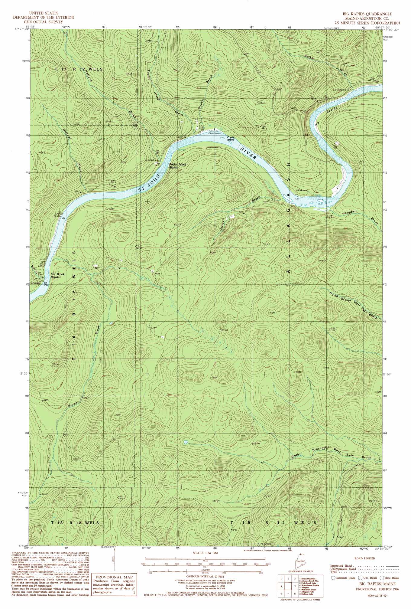
Big Rapids Topo Map Maine
To zoom in, hover over the map of Big Rapids
USGS Topo Quad 47069a2 - 1:24,000 scale
| Topo Map Name: | Big Rapids |
| USGS Topo Quad ID: | 47069a2 |
| Print Size: | ca. 21 1/4" wide x 27" high |
| Southeast Coordinates: | 47° N latitude / 69.125° W longitude |
| Map Center Coordinates: | 47.0625° N latitude / 69.1875° W longitude |
| U.S. State: | ME |
| Filename: | o47069a2.jpg |
| Download Map JPG Image: | Big Rapids topo map 1:24,000 scale |
| Map Type: | Topographic |
| Topo Series: | 7.5´ |
| Map Scale: | 1:24,000 |
| Source of Map Images: | United States Geological Survey (USGS) |
| Alternate Map Versions: |
Big Rapids ME 1986, updated 1987 Download PDF Buy paper map Big Rapids ME 2011 Download PDF Buy paper map Big Rapids ME 2014 Download PDF Buy paper map |
1:24,000 Topo Quads surrounding Big Rapids
Morrison Brook |
Rocky Brook |
Hafey Pond |
Beau Lake |
|
Rocky Mountain Nw |
Rocky Mountain |
Johnson Brook Mountain |
Falls Brook Lake |
Saint Francis |
Rocky Mountain Sw |
Schoolhouse Rapids |
Big Rapids |
Allagash |
Second Lake |
Big Black Rapids |
Mckinnon Brook |
Allagash Falls |
Mckeen Lake |
Gardner Pond |
Blue Brook |
Round Pond |
Five Finger Brook |
Big Brook Lake |
Fish River Lake Sw |
> Back to 47069a1 at 1:100,000 scale
> Back to 47068a1 at 1:250,000 scale
> Back to U.S. Topo Maps home
Big Rapids topo map: Gazetteer
Big Rapids: Rapids
Big Rapids elevation 192m 629′Fox Brook Rapids elevation 206m 675′
Poplar Island Rapids elevation 203m 666′
Big Rapids: Streams
Bishop Brook elevation 203m 666′Brown Brook elevation 207m 679′
Campbell Brook elevation 201m 659′
Carter Brook elevation 200m 656′
Fox Brook elevation 208m 682′
Hafford Brook elevation 210m 688′
Halfway Brook elevation 206m 675′
Poplar Island Brook elevation 207m 679′
Walker Brook elevation 190m 623′
Big Rapids digital topo map on disk
Buy this Big Rapids topo map showing relief, roads, GPS coordinates and other geographical features, as a high-resolution digital map file on DVD:
Maine, New Hampshire, Rhode Island & Eastern Massachusetts
Buy digital topo maps: Maine, New Hampshire, Rhode Island & Eastern Massachusetts