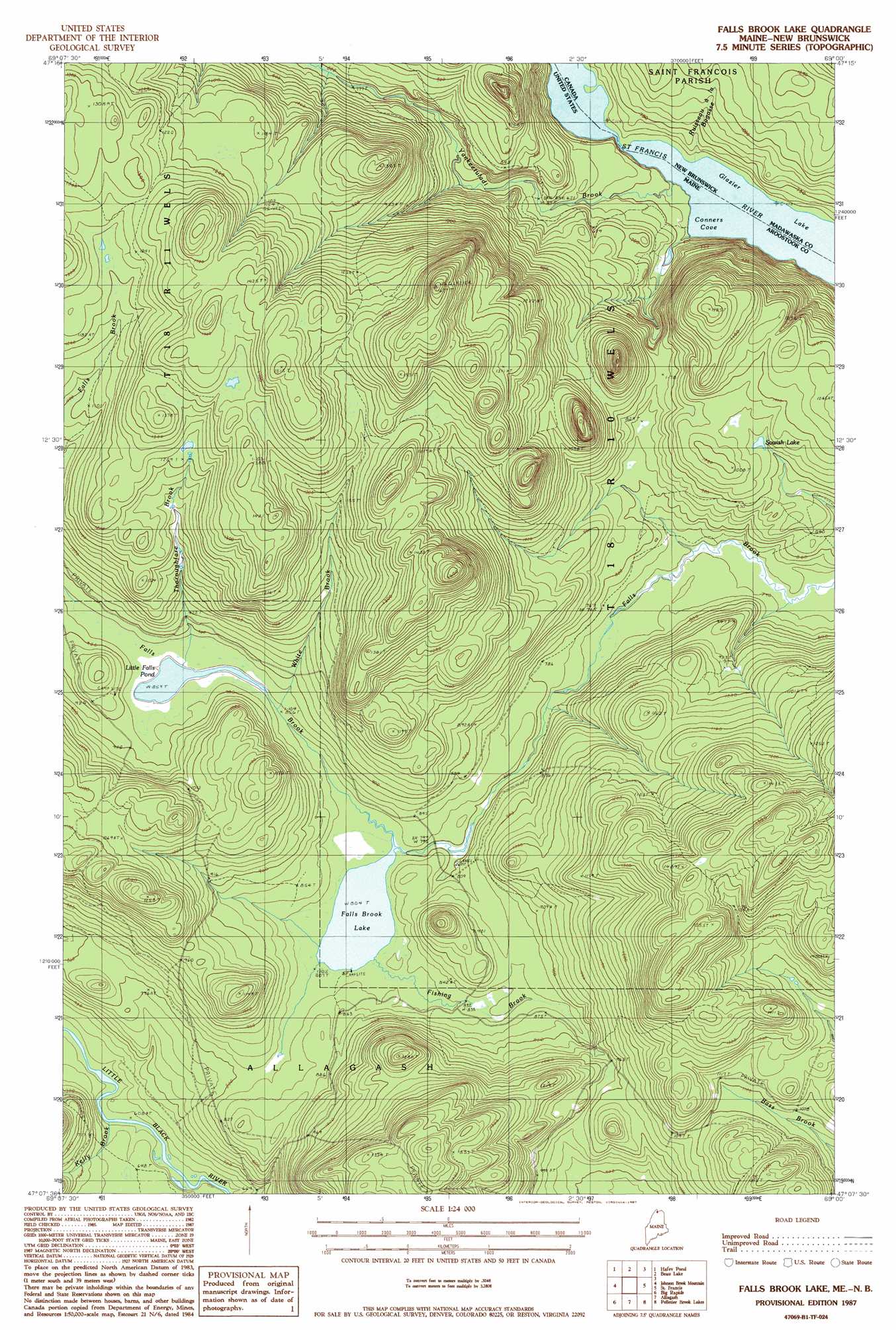
Falls Brook Lake Topo Map Maine
To zoom in, hover over the map of Falls Brook Lake
USGS Topo Quad 47069b1 - 1:24,000 scale
| Topo Map Name: | Falls Brook Lake |
| USGS Topo Quad ID: | 47069b1 |
| Print Size: | ca. 21 1/4" wide x 27" high |
| Southeast Coordinates: | 47.125° N latitude / 69° W longitude |
| Map Center Coordinates: | 47.1875° N latitude / 69.0625° W longitude |
| U.S. State: | ME |
| Filename: | o47069b1.jpg |
| Download Map JPG Image: | Falls Brook Lake topo map 1:24,000 scale |
| Map Type: | Topographic |
| Topo Series: | 7.5´ |
| Map Scale: | 1:24,000 |
| Source of Map Images: | United States Geological Survey (USGS) |
| Alternate Map Versions: |
Falls Brook Lake ME 1987, updated 1987 Download PDF Buy paper map Falls Brook Lake ME 2011 Download PDF Buy paper map Falls Brook Lake ME 2014 Download PDF Buy paper map |
1:24,000 Topo Quads surrounding Falls Brook Lake
Saint Eleuthere |
Estcourt |
Landry |
||
Rocky Brook |
Hafey Pond |
Beau Lake |
||
Rocky Mountain |
Johnson Brook Mountain |
Falls Brook Lake |
Saint Francis |
Saint John |
Schoolhouse Rapids |
Big Rapids |
Allagash |
Second Lake |
Mclean Mountain |
Mckinnon Brook |
Allagash Falls |
Mckeen Lake |
Gardner Pond |
Deboullie Pond |
> Back to 47069a1 at 1:100,000 scale
> Back to 47068a1 at 1:250,000 scale
> Back to U.S. Topo Maps home
Falls Brook Lake topo map: Gazetteer
Falls Brook Lake: Lakes
Falls Brook Lake elevation 245m 803′Little Falls Pond elevation 262m 859′
McPherson Pond elevation 172m 564′
Sowish Lake elevation 282m 925′
Falls Brook Lake: Streams
Falls Brook elevation 268m 879′Fishing Brook elevation 245m 803′
Kelly Brook elevation 187m 613′
Thoroughfare Brook elevation 268m 879′
White Brook elevation 258m 846′
Yankeetuladi Brook elevation 172m 564′
Falls Brook Lake digital topo map on disk
Buy this Falls Brook Lake topo map showing relief, roads, GPS coordinates and other geographical features, as a high-resolution digital map file on DVD:
Maine, New Hampshire, Rhode Island & Eastern Massachusetts
Buy digital topo maps: Maine, New Hampshire, Rhode Island & Eastern Massachusetts