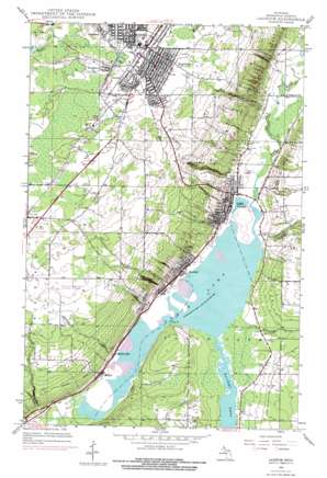
Laurium Topo Map Michigan
To zoom in, hover over the map of Laurium
USGS Topo Quad 47088b4 - 1:24,000 scale
| Topo Map Name: | Laurium |
| USGS Topo Quad ID: | 47088b4 |
| Print Size: | ca. 21 1/4" wide x 27" high |
| Southeast Coordinates: | 47.125° N latitude / 88.375° W longitude |
| Map Center Coordinates: | 47.1875° N latitude / 88.4375° W longitude |
| U.S. State: | MI |
| Filename: | o47088b4.jpg |
| Download Map JPG Image: | Laurium topo map 1:24,000 scale |
| Map Type: | Topographic |
| Topo Series: | 7.5´ |
| Map Scale: | 1:24,000 |
| Source of Map Images: | United States Geological Survey (USGS) |
| Alternate Map Versions: |
Laurium MI 1946, updated 1974 Download PDF Buy paper map Laurium MI 1946, updated 1976 Download PDF Buy paper map Laurium MI 1948, updated 1948 Download PDF Buy paper map Laurium MI 1978, updated 1980 Download PDF Buy paper map Laurium MI 2011 Download PDF Buy paper map Laurium MI 2014 Download PDF Buy paper map Laurium MI 2017 Download PDF Buy paper map |
1:24,000 Topo Quads surrounding Laurium
> Back to 47088a1 at 1:100,000 scale
> Back to 47088a1 at 1:250,000 scale
> Back to U.S. Topo Maps home
Laurium topo map: Gazetteer
Laurium: Airports
Houghton County Memorial Airport elevation 324m 1062′Hougton County Memorial Airport elevation 324m 1062′
Laurium: Canals
Torch Lake elevation 184m 603′Laurium: Capes
Ureux Point elevation 189m 620′Laurium: Cliffs
Louis Hill elevation 248m 813′Laurium: Falls
Houghton Falls elevation 276m 905′Hungarian Falls elevation 224m 734′
Laurium: Lakes
Torch Lake elevation 184m 603′Laurium: Parks
Agassiz Park elevation 371m 1217′Calumet Theater Historical Marker elevation 370m 1213′
Italian Hall Historical Marker elevation 371m 1217′
Saint Paul the Apostle Church Historical Marker elevation 371m 1217′
Suomi Synod Historical Marker elevation 374m 1227′
Laurium: Populated Places
Calumet elevation 370m 1213′Gregoryville elevation 188m 616′
Hubbell elevation 191m 626′
Lake Linden elevation 189m 620′
Laurium elevation 373m 1223′
Mason elevation 194m 636′
Osceola elevation 373m 1223′
Quincy Mill elevation 192m 629′
Swedetown elevation 376m 1233′
Tamarack elevation 385m 1263′
Laurium: Post Offices
Calumet Post Office elevation 372m 1220′Horju Post Office (historical) elevation 358m 1174′
Hubbell Post Office elevation 192m 629′
Lake Linden Post Office elevation 190m 623′
Laurium Post Office (historical) elevation 373m 1223′
Osceola Post Office (historical) elevation 373m 1223′
Red Jacket Post Office (historical) elevation 377m 1236′
Laurium: Streams
Dover Creek elevation 188m 616′Hammell Creek elevation 186m 610′
McCallum Creek elevation 186m 610′
Quincy Creek elevation 187m 613′
Sawmill Creek elevation 188m 616′
Trap Rock River elevation 184m 603′
Laurium digital topo map on disk
Buy this Laurium topo map showing relief, roads, GPS coordinates and other geographical features, as a high-resolution digital map file on DVD:


