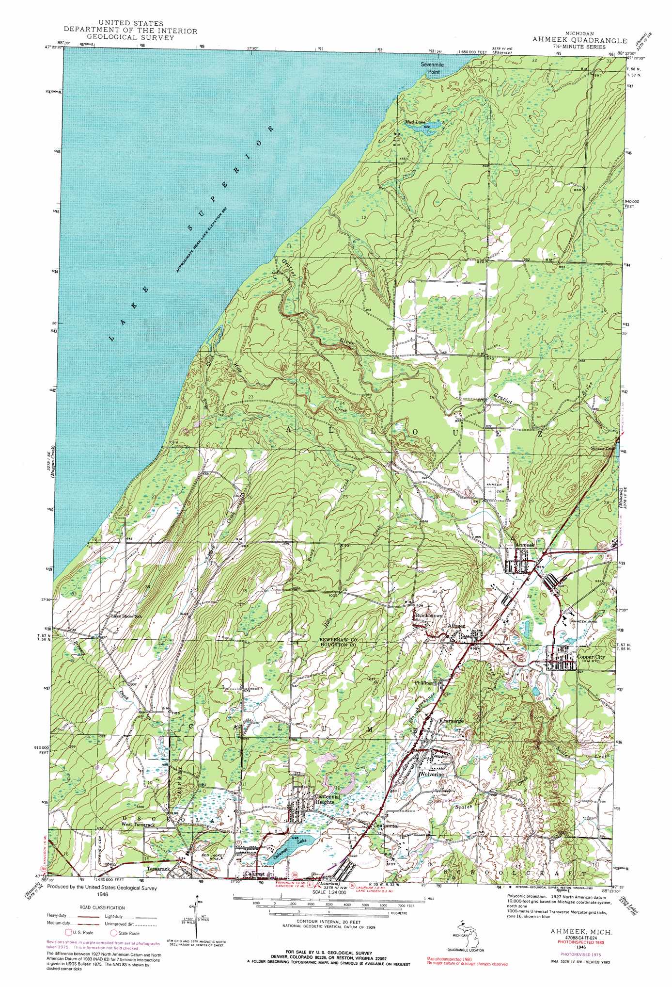
Ahmeek Topo Map Michigan
To zoom in, hover over the map of Ahmeek
USGS Topo Quad 47088c4 - 1:24,000 scale
| Topo Map Name: | Ahmeek |
| USGS Topo Quad ID: | 47088c4 |
| Print Size: | ca. 21 1/4" wide x 27" high |
| Southeast Coordinates: | 47.25° N latitude / 88.375° W longitude |
| Map Center Coordinates: | 47.3125° N latitude / 88.4375° W longitude |
| U.S. State: | MI |
| Filename: | o47088c4.jpg |
| Download Map JPG Image: | Ahmeek topo map 1:24,000 scale |
| Map Type: | Topographic |
| Topo Series: | 7.5´ |
| Map Scale: | 1:24,000 |
| Source of Map Images: | United States Geological Survey (USGS) |
| Alternate Map Versions: |
Ahmeek MI 1946, updated 1971 Download PDF Buy paper map Ahmeek MI 1946, updated 1976 Download PDF Buy paper map Ahmeek MI 1946, updated 1992 Download PDF Buy paper map Ahmeek MI 1947 Download PDF Buy paper map Ahmeek MI 1947 Download PDF Buy paper map Ahmeek MI 2011 Download PDF Buy paper map Ahmeek MI 2014 Download PDF Buy paper map Ahmeek MI 2017 Download PDF Buy paper map |
1:24,000 Topo Quads surrounding Ahmeek
Phoenix |
Eagle Harbor |
|||
Muggun Creek |
Ahmeek |
Mohawk |
Bruneau Creek |
|
Oskar |
Hancock |
Laurium |
Rice Lake |
Gay |
South Range |
Chassell |
Point Mills |
Traverse Island |
> Back to 47088a1 at 1:100,000 scale
> Back to 47088a1 at 1:250,000 scale
> Back to U.S. Topo Maps home
Ahmeek topo map: Gazetteer
Ahmeek: Capes
Sevenmile Point elevation 184m 603′Ahmeek: Falls
Lower Falls elevation 202m 662′Upper Falls elevation 207m 679′
Ahmeek: Lakes
Calumet Lake elevation 363m 1190′Turtle Lake elevation 192m 629′
Ahmeek: Mines
Ahmeek Mine elevation 271m 889′Red Jacket Mine elevation 369m 1210′
Ahmeek: Populated Places
Ahmeek elevation 265m 869′Allouez elevation 307m 1007′
Bumbletown elevation 352m 1154′
Centennial elevation 366m 1200′
Centennial Heights elevation 376m 1233′
Copper City elevation 267m 875′
Kearsarge elevation 342m 1122′
Lakeview elevation 346m 1135′
Phillipsville elevation 329m 1079′
West Tamarack elevation 377m 1236′
Wolverine elevation 348m 1141′
Ahmeek: Post Offices
Ahmeek Post Office elevation 266m 872′Allouez Post Office (historical) elevation 307m 1007′
Copper City Post Office elevation 267m 875′
Kearsage Post Office (historical) elevation 342m 1122′
Ahmeek: Streams
Black Creek elevation 188m 616′Finey Creek elevation 236m 774′
Fulton Creek elevation 262m 859′
Gratiot River elevation 184m 603′
Hills Creek elevation 189m 620′
Slaughterhouse Creek elevation 229m 751′
Ahmeek digital topo map on disk
Buy this Ahmeek topo map showing relief, roads, GPS coordinates and other geographical features, as a high-resolution digital map file on DVD: