Eagle Harbor Topo Map Michigan
To zoom in, hover over the map of Eagle Harbor
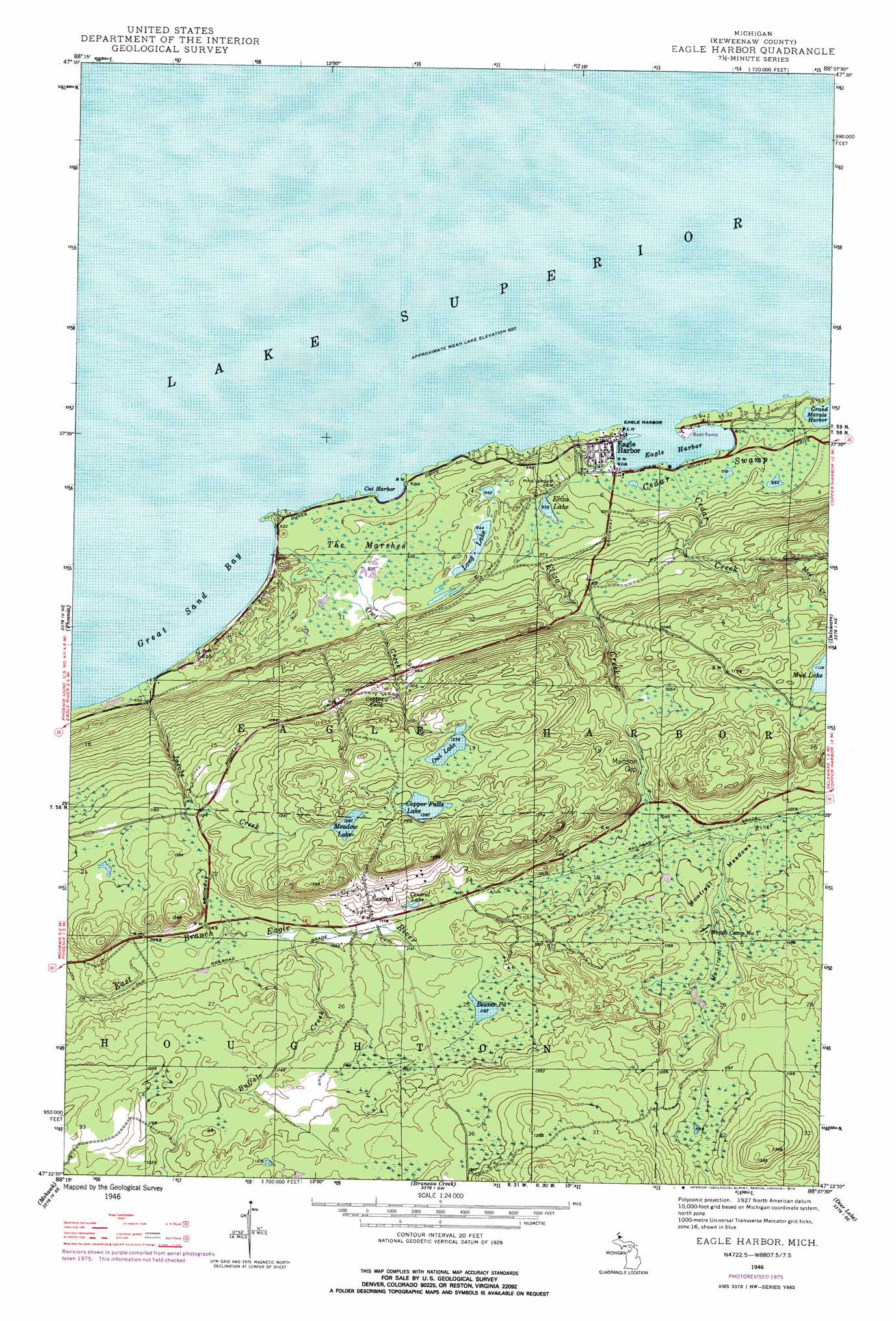
USGS Topo Quad 47088d2 - 1:24,000 scale
| Topo Map Name: | Eagle Harbor |
| USGS Topo Quad ID: | 47088d2 |
| Print Size: | ca. 21 1/4" wide x 27" high |
| Southeast Coordinates: | 47.375° N latitude / 88.125° W longitude |
| Map Center Coordinates: | 47.4375° N latitude / 88.1875° W longitude |
| U.S. State: | MI |
| Filename: | o47088d2.jpg |
| Download Map JPG Image: | Eagle Harbor topo map 1:24,000 scale |
| Map Type: | Topographic |
| Topo Series: | 7.5´ |
| Map Scale: | 1:24,000 |
| Source of Map Images: | United States Geological Survey (USGS) |
| Alternate Map Versions: |
Eagle Harbor MI 1946, updated 1968 Download PDF Buy paper map Eagle Harbor MI 1946, updated 1976 Download PDF Buy paper map Eagle Harbor MI 1946, updated 1976 Download PDF Buy paper map Eagle Harbor MI 1948, updated 1948 Download PDF Buy paper map Eagle Harbor MI 2011 Download PDF Buy paper map Eagle Harbor MI 2014 Download PDF Buy paper map Eagle Harbor MI 2017 Download PDF Buy paper map |
1:24,000 Topo Quads surrounding Eagle Harbor
Phoenix |
Eagle Harbor |
Delaware |
Lake Medora |
|
Ahmeek |
Mohawk |
Bruneau Creek |
Deer Lake |
Point Isabelle |
Laurium |
Rice Lake |
Gay |
> Back to 47088a1 at 1:100,000 scale
> Back to 47088a1 at 1:250,000 scale
> Back to U.S. Topo Maps home
Eagle Harbor topo map: Gazetteer
Eagle Harbor: Bays
Cat Harbor elevation 183m 600′Eagle Harbor elevation 183m 600′
Great Sand Bay elevation 183m 600′
Eagle Harbor: Falls
Copper Falls elevation 304m 997′Jacobs Falls elevation 217m 711′
Eagle Harbor: Flats
Montreal Meadows elevation 330m 1082′Eagle Harbor: Lakes
Beaver Pond elevation 356m 1167′Central Lake elevation 347m 1138′
Copper Falls Lake elevation 392m 1286′
Eliza Lake elevation 193m 633′
Long Lake elevation 196m 643′
Meadow Lake elevation 384m 1259′
Owl Lake elevation 374m 1227′
Eagle Harbor: Parks
Eagle Harbor House Historical Marker elevation 187m 613′Eagle Harbor: Populated Places
Central elevation 367m 1204′Copper Falls elevation 309m 1013′
Eagle Harbor elevation 189m 620′
Nepco Camp Number 7 elevation 340m 1115′
Eagle Harbor: Post Offices
Central Mine Post Office (historical) elevation 367m 1204′Eagle Harbor Post Office (historical) elevation 189m 620′
Eagle Harbor Post Office (historical) elevation 189m 620′
Eagle Harbor: Streams
Buffalo Creek elevation 328m 1076′Cedar Creek elevation 185m 606′
Eliza Creek elevation 186m 610′
Jacobs Creek elevation 183m 600′
Mud Creek elevation 279m 915′
Owl Creek elevation 185m 606′
Eagle Harbor: Swamps
Cedar Swamp elevation 188m 616′Madison Gap elevation 332m 1089′
The Marshes elevation 189m 620′
Eagle Harbor digital topo map on disk
Buy this Eagle Harbor topo map showing relief, roads, GPS coordinates and other geographical features, as a high-resolution digital map file on DVD: