Honeymoon Mountain Topo Map Minnesota
To zoom in, hover over the map of Honeymoon Mountain
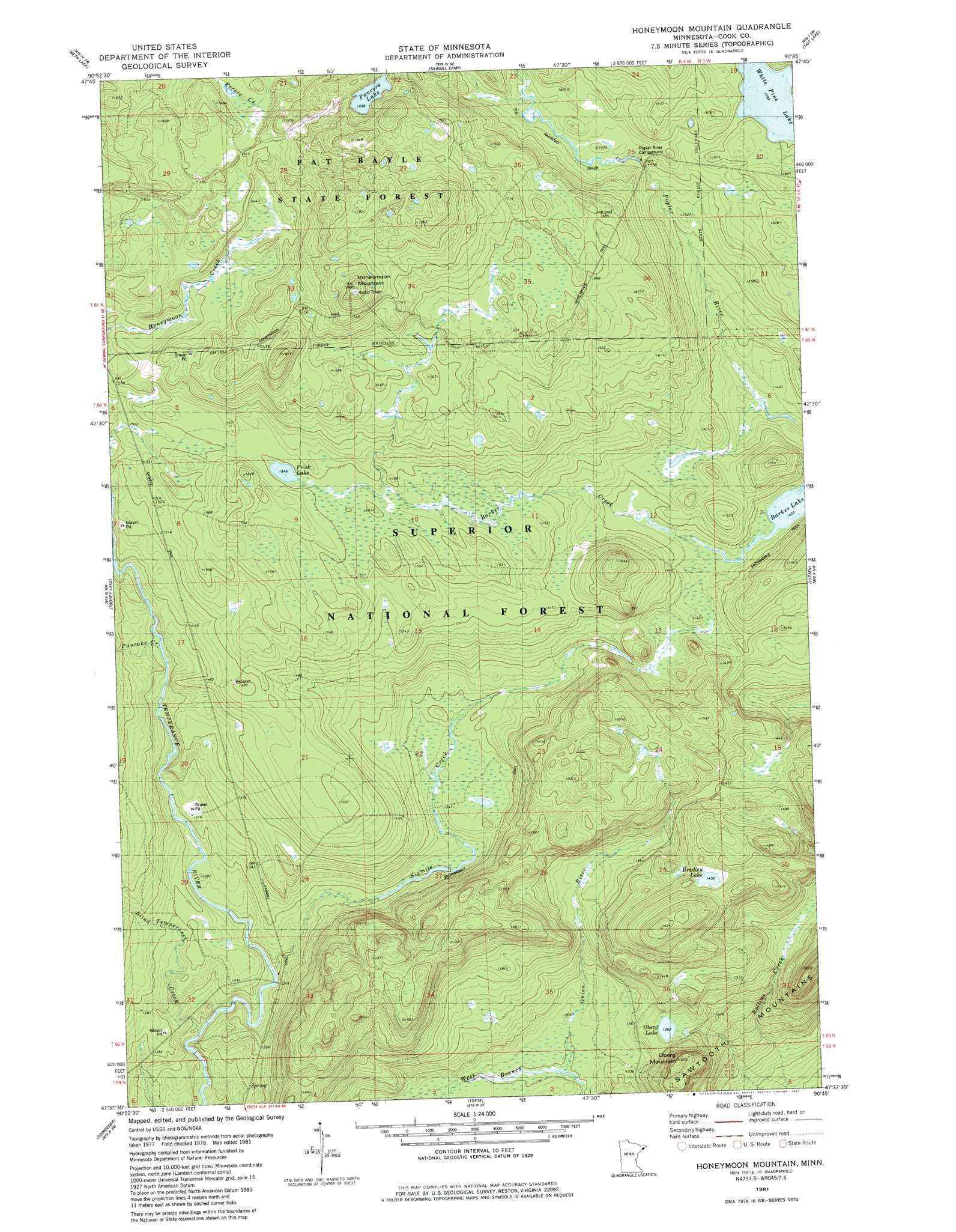
USGS Topo Quad 47090f7 - 1:24,000 scale
| Topo Map Name: | Honeymoon Mountain |
| USGS Topo Quad ID: | 47090f7 |
| Print Size: | ca. 21 1/4" wide x 27" high |
| Southeast Coordinates: | 47.625° N latitude / 90.75° W longitude |
| Map Center Coordinates: | 47.6875° N latitude / 90.8125° W longitude |
| U.S. State: | MN |
| Filename: | o47090f7.jpg |
| Download Map JPG Image: | Honeymoon Mountain topo map 1:24,000 scale |
| Map Type: | Topographic |
| Topo Series: | 7.5´ |
| Map Scale: | 1:24,000 |
| Source of Map Images: | United States Geological Survey (USGS) |
| Alternate Map Versions: |
Honeymoon Mountain MN 1981, updated 1982 Download PDF Buy paper map Honeymoon Mountain MN 2011 Download PDF Buy paper map Honeymoon Mountain MN 2013 Download PDF Buy paper map Honeymoon Mountain MN 2016 Download PDF Buy paper map |
| FStopo: | US Forest Service topo Honeymoon Mountain is available: Download FStopo PDF Download FStopo TIF |
1:24,000 Topo Quads surrounding Honeymoon Mountain
Lake Polly |
Kelso Mountain |
Cherokee Lake |
Brule Lake |
Eagle Mountain |
Kawishiwi Lake |
Beth Lake |
Sawbill Camp |
Tait Lake |
Mark Lake |
Wilson Lake |
Toohey Lake |
Honeymoon Mountain |
Lutsen |
Deer Yard Lake |
Cramer |
Schroeder |
Tofte |
||
Little Marais |
> Back to 47090e1 at 1:100,000 scale
> Back to 47090a1 at 1:250,000 scale
> Back to U.S. Topo Maps home
Honeymoon Mountain topo map: Gazetteer
Honeymoon Mountain: Lakes
Bradley Lake elevation 443m 1453′Frisk Lake elevation 471m 1545′
Oberg Lake elevation 385m 1263′
Pancore Lake elevation 518m 1699′
Honeymoon Mountain: Ranges
Sawtooth Mountains elevation 433m 1420′Honeymoon Mountain: Streams
Barker Creek elevation 434m 1423′Blind Temperance Creek elevation 361m 1184′
Pancake Creek elevation 423m 1387′
Sixmile Creek elevation 375m 1230′
West Branch Onion River elevation 366m 1200′
Honeymoon Mountain: Summits
Honeymoon Mountain elevation 578m 1896′Oberg Mountain elevation 470m 1541′
Honeymoon Mountain: Trails
Honeymoon Trail elevation 521m 1709′Honeymoon Mountain digital topo map on disk
Buy this Honeymoon Mountain topo map showing relief, roads, GPS coordinates and other geographical features, as a high-resolution digital map file on DVD: