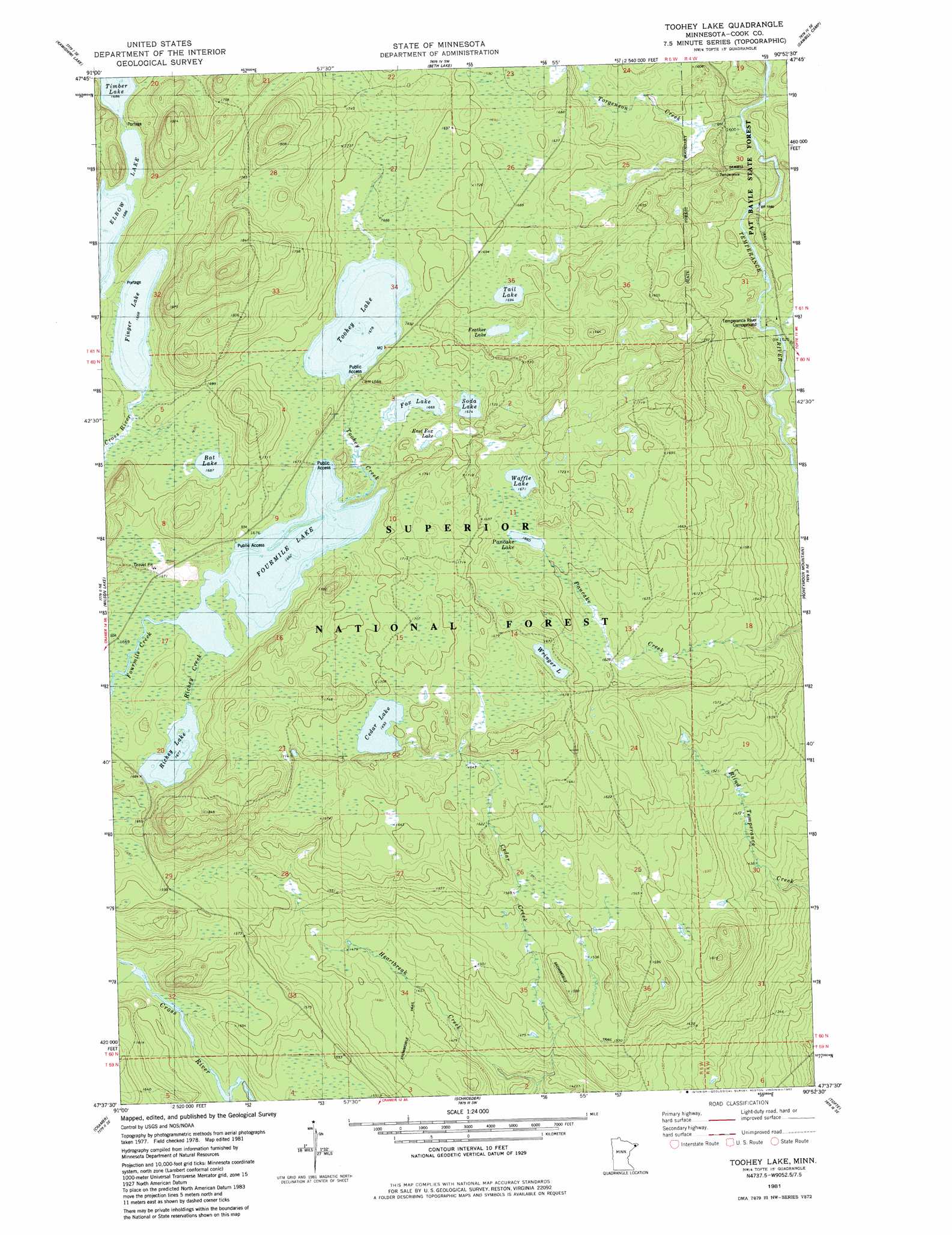
Toohey Lake Topo Map Minnesota
To zoom in, hover over the map of Toohey Lake
USGS Topo Quad 47090f8 - 1:24,000 scale
| Topo Map Name: | Toohey Lake |
| USGS Topo Quad ID: | 47090f8 |
| Print Size: | ca. 21 1/4" wide x 27" high |
| Southeast Coordinates: | 47.625° N latitude / 90.875° W longitude |
| Map Center Coordinates: | 47.6875° N latitude / 90.9375° W longitude |
| U.S. State: | MN |
| Filename: | o47090f8.jpg |
| Download Map JPG Image: | Toohey Lake topo map 1:24,000 scale |
| Map Type: | Topographic |
| Topo Series: | 7.5´ |
| Map Scale: | 1:24,000 |
| Source of Map Images: | United States Geological Survey (USGS) |
| Alternate Map Versions: |
Toohey Lake MN 1981, updated 1982 Download PDF Buy paper map Toohey Lake MN 2011 Download PDF Buy paper map Toohey Lake MN 2013 Download PDF Buy paper map Toohey Lake MN 2016 Download PDF Buy paper map |
| FStopo: | US Forest Service topo Toohey Lake is available: Download FStopo PDF Download FStopo TIF |
1:24,000 Topo Quads surrounding Toohey Lake
Alice Lake |
Lake Polly |
Kelso Mountain |
Cherokee Lake |
Brule Lake |
Perent Lake |
Kawishiwi Lake |
Beth Lake |
Sawbill Camp |
Tait Lake |
Silver Island Lake |
Wilson Lake |
Toohey Lake |
Honeymoon Mountain |
Lutsen |
Cabin Lake |
Cramer |
Schroeder |
Tofte |
|
Finland |
Little Marais |
> Back to 47090e1 at 1:100,000 scale
> Back to 47090a1 at 1:250,000 scale
> Back to U.S. Topo Maps home
Toohey Lake topo map: Gazetteer
Toohey Lake: Lakes
Bat Lake elevation 514m 1686′Cedar Lake elevation 516m 1692′
East Fox Lake elevation 511m 1676′
Feather Lake elevation 520m 1706′
Finger Lake elevation 509m 1669′
Fourmile Lake elevation 508m 1666′
Fox Lake elevation 509m 1669′
Pancake Lake elevation 506m 1660′
Richey Lake elevation 511m 1676′
Soda Lake elevation 511m 1676′
Tail Lake elevation 516m 1692′
Toohey Lake elevation 512m 1679′
Waffle Lake elevation 509m 1669′
Wringer Lake elevation 508m 1666′
Toohey Lake: Streams
Cedar Creek elevation 418m 1371′Honeymoon Creek elevation 460m 1509′
Richey Creek elevation 508m 1666′
Toohey Creek elevation 508m 1666′
Torgenson Creek elevation 476m 1561′
Toohey Lake digital topo map on disk
Buy this Toohey Lake topo map showing relief, roads, GPS coordinates and other geographical features, as a high-resolution digital map file on DVD: