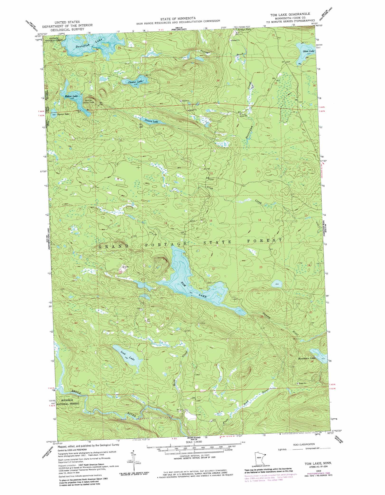
Tom Lake Topo Map Minnesota
To zoom in, hover over the map of Tom Lake
USGS Topo Quad 47090h1 - 1:24,000 scale
| Topo Map Name: | Tom Lake |
| USGS Topo Quad ID: | 47090h1 |
| Print Size: | ca. 21 1/4" wide x 27" high |
| Southeast Coordinates: | 47.875° N latitude / 90° W longitude |
| Map Center Coordinates: | 47.9375° N latitude / 90.0625° W longitude |
| U.S. State: | MN |
| Filename: | o47090h1.jpg |
| Download Map JPG Image: | Tom Lake topo map 1:24,000 scale |
| Map Type: | Topographic |
| Topo Series: | 7.5´ |
| Map Scale: | 1:24,000 |
| Source of Map Images: | United States Geological Survey (USGS) |
| Alternate Map Versions: |
Tom Lake MN 1959, updated 1962 Download PDF Buy paper map Tom Lake MN 1959, updated 1965 Download PDF Buy paper map Tom Lake MN 1959, updated 1986 Download PDF Buy paper map Tom Lake MN 2011 Download PDF Buy paper map Tom Lake MN 2013 Download PDF Buy paper map Tom Lake MN 2016 Download PDF Buy paper map |
| FStopo: | US Forest Service topo Tom Lake is available: Download FStopo PDF Download FStopo TIF |
1:24,000 Topo Quads surrounding Tom Lake
Crocodile Lake |
Pine Lake West |
Pine Lake East |
South Fowl Lake |
The Cascades |
Pine Mountain |
Northern Light Lake |
Tom Lake |
Farquhar Peak |
Mineral Center |
Grand Marais |
Kadunce River |
Marr Island |
Hovland |
|
Good Harbor Bay |
> Back to 47090e1 at 1:100,000 scale
> Back to 47090a1 at 1:250,000 scale
> Back to U.S. Topo Maps home
Tom Lake topo map: Gazetteer
Tom Lake: Falls
Portage Falls elevation 473m 1551′Tom Lake: Lakes
Chester Lake elevation 572m 1876′Devilfish Lake elevation 570m 1870′
Esther Lake elevation 597m 1958′
Lost Lake elevation 452m 1482′
Olga Lake elevation 590m 1935′
Otter Lake elevation 492m 1614′
Powers Lake elevation 558m 1830′
Tom Lake elevation 495m 1624′
Tom Lake: Streams
Beaverdam Creek elevation 484m 1587′Mons Creek elevation 385m 1263′
Tom Lake: Summits
Farquhar Knob elevation 536m 1758′Tom Lake digital topo map on disk
Buy this Tom Lake topo map showing relief, roads, GPS coordinates and other geographical features, as a high-resolution digital map file on DVD: