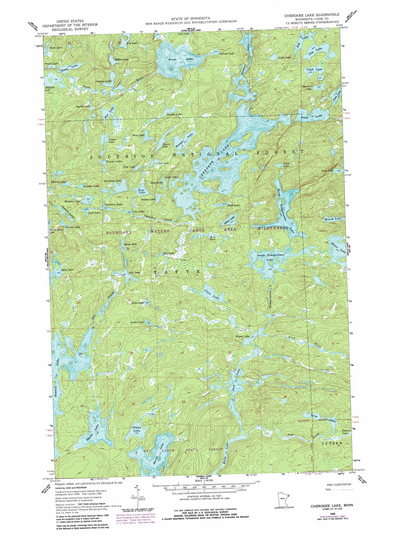
Cherokee Lake Topo Map Minnesota
To zoom in, hover over the map of Cherokee Lake
USGS Topo Quad 47090h7 - 1:24,000 scale
| Topo Map Name: | Cherokee Lake |
| USGS Topo Quad ID: | 47090h7 |
| Print Size: | ca. 21 1/4" wide x 27" high |
| Southeast Coordinates: | 47.875° N latitude / 90.75° W longitude |
| Map Center Coordinates: | 47.9375° N latitude / 90.8125° W longitude |
| U.S. State: | MN |
| Filename: | o47090h7.jpg |
| Download Map JPG Image: | Cherokee Lake topo map 1:24,000 scale |
| Map Type: | Topographic |
| Topo Series: | 7.5´ |
| Map Scale: | 1:24,000 |
| Source of Map Images: | United States Geological Survey (USGS) |
| Alternate Map Versions: |
Cherokee Lake MN 1960, updated 1962 Download PDF Buy paper map Cherokee Lake MN 1960, updated 1965 Download PDF Buy paper map Cherokee Lake MN 1960, updated 1986 Download PDF Buy paper map Cherokee Lake MN 2011 Download PDF Buy paper map Cherokee Lake MN 2013 Download PDF Buy paper map Cherokee Lake MN 2016 Download PDF Buy paper map |
| FStopo: | US Forest Service topo Cherokee Lake is available: Download FStopo PDF Download FStopo TIF |
1:24,000 Topo Quads surrounding Cherokee Lake
Ester Lake |
Munker Island |
Conners Island |
||
Ogishkemuncie Lake |
Gillis Lake |
Long Island Lake |
Gunflint Lake |
South Lake |
Lake Polly |
Kelso Mountain |
Cherokee Lake |
Brule Lake |
Eagle Mountain |
Kawishiwi Lake |
Beth Lake |
Sawbill Camp |
Tait Lake |
Mark Lake |
Wilson Lake |
Toohey Lake |
Honeymoon Mountain |
Lutsen |
Deer Yard Lake |
> Back to 47090e1 at 1:100,000 scale
> Back to 47090a1 at 1:250,000 scale
> Back to U.S. Topo Maps home
Cherokee Lake topo map: Gazetteer
Cherokee Lake: Lakes
Ada Lake elevation 553m 1814′Arctic Lake elevation 551m 1807′
Aria Lake elevation 558m 1830′
Ash Lake elevation 556m 1824′
Bologna Lake elevation 524m 1719′
Burnt Lake elevation 541m 1774′
Cede Lake elevation 550m 1804′
Chase Lake elevation 520m 1706′
Cherokee Lake elevation 545m 1788′
Choker Lake elevation 564m 1850′
Clam Lake elevation 553m 1814′
Cleft Lake elevation 558m 1830′
Cream Lake elevation 570m 1870′
Dalbec Lake elevation 552m 1811′
Fetters Lake elevation 539m 1768′
Flame Lake elevation 544m 1784′
Frost Lake elevation 541m 1774′
Fur Lake elevation 552m 1811′
Gordon Lake elevation 541m 1774′
Guard Lake elevation 572m 1876′
Gunstock Lake elevation 568m 1863′
Herb Lake elevation 563m 1847′
Hide Lake elevation 560m 1837′
Iris Lake elevation 552m 1811′
Jack Lake elevation 534m 1751′
Java Lake elevation 550m 1804′
Jay Lake elevation 557m 1827′
Myth Lake elevation 533m 1748′
Night Lake elevation 564m 1850′
No Sleep Lake elevation 558m 1830′
Noodle Lake elevation 564m 1850′
North Temperance Lake elevation 560m 1837′
Octopus Lake elevation 530m 1738′
Olio Lake elevation 576m 1889′
Ranger Lake elevation 571m 1873′
Siamese Lakes elevation 564m 1850′
Sitka Lake elevation 559m 1833′
Skoop Lake elevation 555m 1820′
Smoke Lake elevation 545m 1788′
Sneaker Lake elevation 566m 1856′
Sniff Lake elevation 545m 1788′
Snip Lake elevation 564m 1850′
Snub Lake elevation 554m 1817′
South Temperance Lake elevation 568m 1863′
Squish Lake elevation 536m 1758′
Stem Lake elevation 564m 1850′
Tent Lake elevation 564m 1850′
Tiny Lake elevation 583m 1912′
Town Lake elevation 547m 1794′
Triplet Lakes elevation 576m 1889′
Unload Lake elevation 541m 1774′
Uva Lake elevation 576m 1889′
Venus Lake elevation 558m 1830′
Vigl Lake elevation 554m 1817′
Violation Lake elevation 552m 1811′
Weird Lake elevation 535m 1755′
Wench Lake elevation 593m 1945′
Wichita Lake elevation 558m 1830′
Wing Lake elevation 570m 1870′
Cherokee Lake: Streams
Ada Creek elevation 545m 1788′Cherokee Creek elevation 545m 1788′
Pipe Creek elevation 534m 1751′
Temperance River elevation 542m 1778′
Vern River elevation 535m 1755′
Cherokee Lake digital topo map on disk
Buy this Cherokee Lake topo map showing relief, roads, GPS coordinates and other geographical features, as a high-resolution digital map file on DVD: