Babbitt Topo Map Minnesota
To zoom in, hover over the map of Babbitt
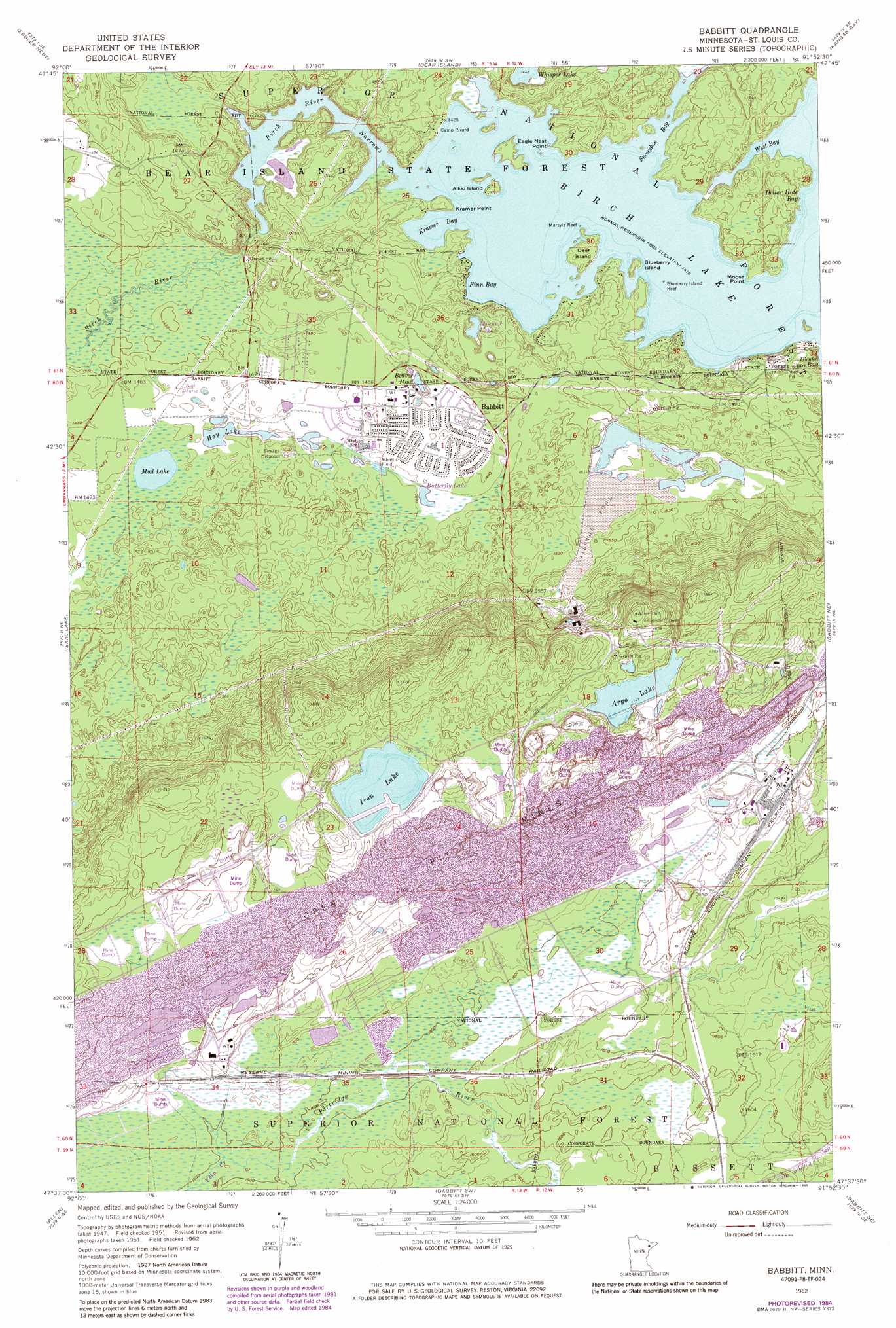
USGS Topo Quad 47091f8 - 1:24,000 scale
| Topo Map Name: | Babbitt |
| USGS Topo Quad ID: | 47091f8 |
| Print Size: | ca. 21 1/4" wide x 27" high |
| Southeast Coordinates: | 47.625° N latitude / 91.875° W longitude |
| Map Center Coordinates: | 47.6875° N latitude / 91.9375° W longitude |
| U.S. State: | MN |
| Filename: | o47091f8.jpg |
| Download Map JPG Image: | Babbitt topo map 1:24,000 scale |
| Map Type: | Topographic |
| Topo Series: | 7.5´ |
| Map Scale: | 1:24,000 |
| Source of Map Images: | United States Geological Survey (USGS) |
| Alternate Map Versions: |
Babbitt MN 1951, updated 1953 Download PDF Buy paper map Babbitt MN 1962, updated 1963 Download PDF Buy paper map Babbitt MN 1962, updated 1971 Download PDF Buy paper map Babbitt MN 1962, updated 1985 Download PDF Buy paper map Babbitt MN 2011 Download PDF Buy paper map Babbitt MN 2013 Download PDF Buy paper map Babbitt MN 2016 Download PDF Buy paper map |
| FStopo: | US Forest Service topo Babbitt is available: Download FStopo PDF Download FStopo TIF |
1:24,000 Topo Quads surrounding Babbitt
Chad Lake |
Crab Lake |
Shagawa Lake |
Ely |
Farm Lake |
Soudan |
Eagles Nest |
Bear Island |
Kangas Bay |
Bogberry Lake |
Embarrass |
Isaac Lake |
Babbitt |
Babbitt Ne |
Slate Lake West |
Aurora |
Allen |
Babbitt Sw |
Babbitt Se |
Greenwood Lake West |
Turpela Lake |
Bird Lake |
Skibo |
Toimi |
Mount Weber |
> Back to 47091e1 at 1:100,000 scale
> Back to 47090a1 at 1:250,000 scale
> Back to U.S. Topo Maps home
Babbitt topo map: Gazetteer
Babbitt: Bars
Blueberry Island Reef elevation 432m 1417′Marsyla Reef elevation 432m 1417′
Babbitt: Bays
Dollar Hide Bay elevation 432m 1417′Finn Bay elevation 432m 1417′
Kramer Bay elevation 432m 1417′
Snowshoe Bay elevation 432m 1417′
West Bay elevation 432m 1417′
Babbitt: Capes
Eagle Nest Point elevation 433m 1420′Kramer Point elevation 436m 1430′
Moose Point elevation 433m 1420′
Babbitt: Channels
Birch River Narrows elevation 444m 1456′Babbitt: Islands
Aikio Island elevation 438m 1437′Blueberry Island elevation 437m 1433′
Deer Island elevation 440m 1443′
Babbitt: Lakes
Argo Lake elevation 533m 1748′Beaver Pond elevation 444m 1456′
Butterfly Lake elevation 451m 1479′
Hay Lake elevation 450m 1476′
Iron Lake elevation 535m 1755′
Minnow Lake elevation 442m 1450′
Mud Lake elevation 450m 1476′
Whisper Lake elevation 442m 1450′
Babbitt: Parks
First Test Pit on the Mesabi Historical Marker elevation 447m 1466′Babbitt: Populated Places
Babbitt elevation 452m 1482′Babbitt: Post Offices
Babbitt Post Office elevation 452m 1482′Babbitt: Streams
Birch River elevation 432m 1417′Yelp Creek elevation 488m 1601′
Babbitt digital topo map on disk
Buy this Babbitt topo map showing relief, roads, GPS coordinates and other geographical features, as a high-resolution digital map file on DVD: