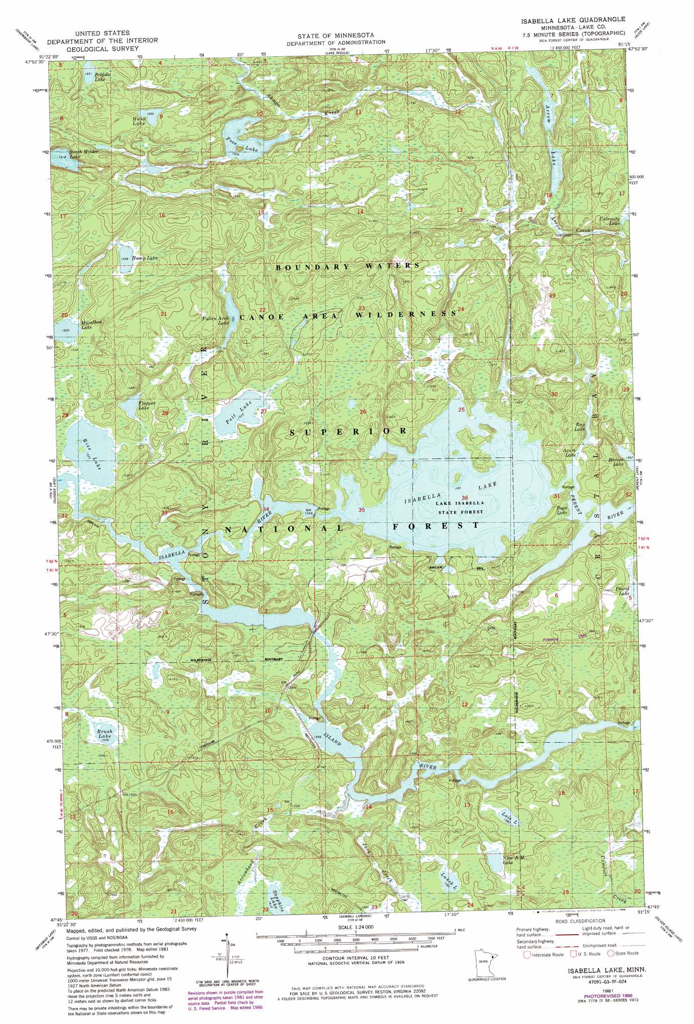
Isabella Lake Topo Map Minnesota
To zoom in, hover over the map of Isabella Lake
USGS Topo Quad 47091g3 - 1:24,000 scale
| Topo Map Name: | Isabella Lake |
| USGS Topo Quad ID: | 47091g3 |
| Print Size: | ca. 21 1/4" wide x 27" high |
| Southeast Coordinates: | 47.75° N latitude / 91.25° W longitude |
| Map Center Coordinates: | 47.8125° N latitude / 91.3125° W longitude |
| U.S. State: | MN |
| Filename: | o47091g3.jpg |
| Download Map JPG Image: | Isabella Lake topo map 1:24,000 scale |
| Map Type: | Topographic |
| Topo Series: | 7.5´ |
| Map Scale: | 1:24,000 |
| Source of Map Images: | United States Geological Survey (USGS) |
| Alternate Map Versions: |
Isabella Lake MN 1981, updated 1982 Download PDF Buy paper map Isabella Lake MN 1981, updated 1986 Download PDF Buy paper map Isabella Lake MN 2011 Download PDF Buy paper map Isabella Lake MN 2013 Download PDF Buy paper map Isabella Lake MN 2016 Download PDF Buy paper map |
| FStopo: | US Forest Service topo Isabella Lake is available: Download FStopo PDF Download FStopo TIF |
1:24,000 Topo Quads surrounding Isabella Lake
Basswood Lake East |
Ensign Lake West |
Ensign Lake East |
Kekekabic Lake |
Ogishkemuncie Lake |
Ojibway Lake |
Snowbank Lake |
Lake Insula |
Alice Lake |
Lake Polly |
Gabbro Lake |
Quadga Lake |
Isabella Lake |
Perent Lake |
Kawishiwi Lake |
Slate Lake East |
Mitawan Lake |
Sawbill Landing |
Silver Island Lake |
Wilson Lake |
Greenwood Lake East |
Isabella Station |
Isabella |
Cabin Lake |
Cramer |
> Back to 47091e1 at 1:100,000 scale
> Back to 47090a1 at 1:250,000 scale
> Back to U.S. Topo Maps home
Isabella Lake topo map: Gazetteer
Isabella Lake: Forests
Isabella Lake State Forest elevation 473m 1551′Isabella Lake: Lakes
Arrow Lake elevation 479m 1571′Azure Lake elevation 475m 1558′
Boga Lake elevation 473m 1551′
Briddle Lake elevation 467m 1532′
Brush Lake elevation 481m 1578′
Fallen Arch Lake elevation 473m 1551′
Flapper Lake elevation 465m 1525′
Hump Lake elevation 475m 1558′
Hush Lake elevation 474m 1555′
Isabella Lake elevation 473m 1551′
Lois Lake elevation 483m 1584′
Lynch Lake elevation 484m 1587′
Marathon Lake elevation 467m 1532′
Nine A M Lake elevation 486m 1594′
Pelt Lake elevation 468m 1535′
Pose Lake elevation 466m 1528′
Rice Lake elevation 464m 1522′
Sapphire Lake elevation 492m 1614′
Isabella Lake: Populated Places
Forest Center elevation 483m 1584′Isabella Lake: Post Offices
Forest Center Post Office (historical) elevation 483m 1584′Isabella Lake: Reservoirs
Rap Lake elevation 477m 1564′Isabella Lake: Streams
Arrow Creek elevation 481m 1578′Arrowhead Creek elevation 473m 1551′
Island River elevation 471m 1545′
Jack Creek elevation 473m 1551′
Perent River elevation 477m 1564′
Isabella Lake: Trails
Powwoun Trail elevation 479m 1571′Isabella Lake digital topo map on disk
Buy this Isabella Lake topo map showing relief, roads, GPS coordinates and other geographical features, as a high-resolution digital map file on DVD: