Snowbank Lake Topo Map Minnesota
To zoom in, hover over the map of Snowbank Lake
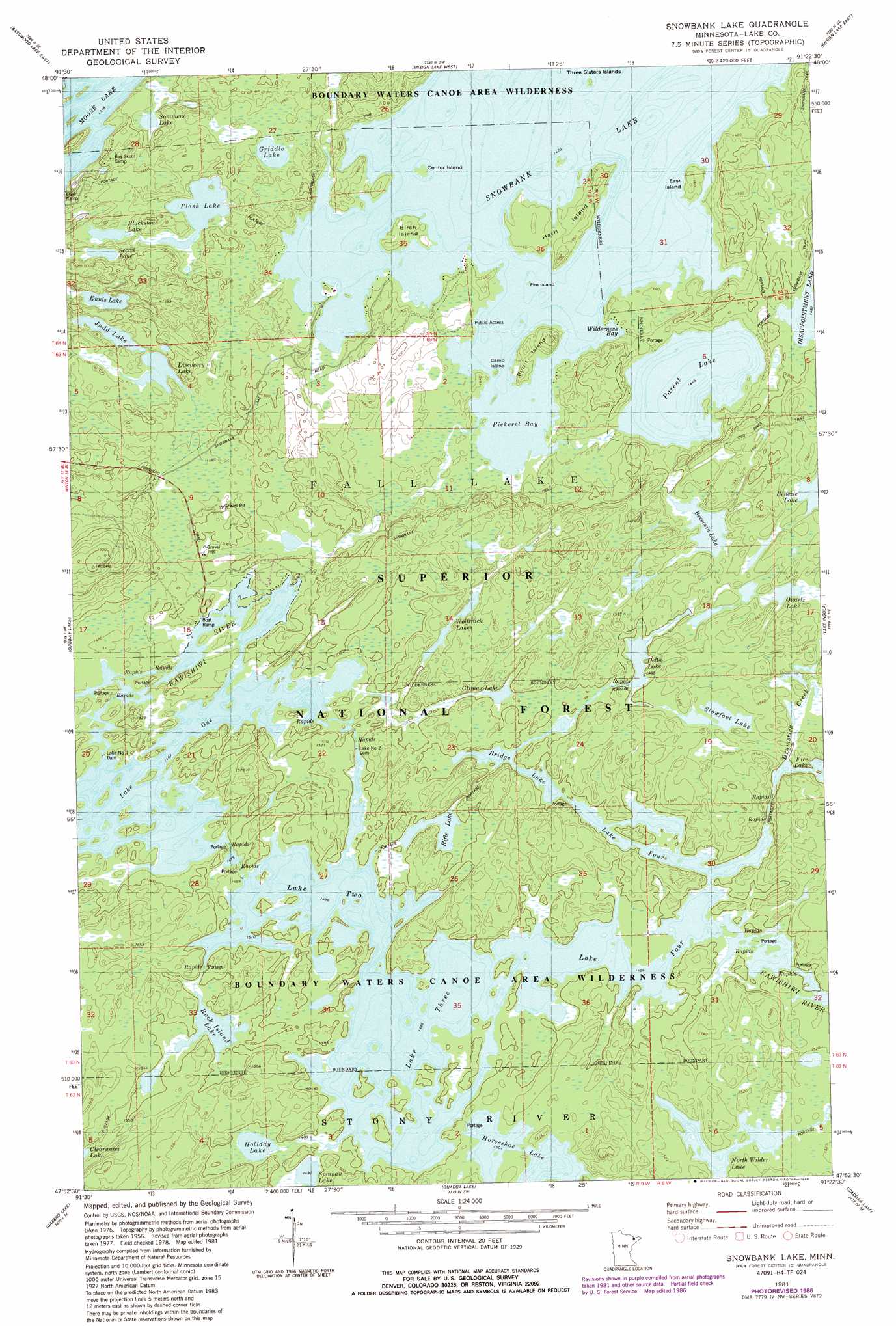
USGS Topo Quad 47091h4 - 1:24,000 scale
| Topo Map Name: | Snowbank Lake |
| USGS Topo Quad ID: | 47091h4 |
| Print Size: | ca. 21 1/4" wide x 27" high |
| Southeast Coordinates: | 47.875° N latitude / 91.375° W longitude |
| Map Center Coordinates: | 47.9375° N latitude / 91.4375° W longitude |
| U.S. State: | MN |
| Filename: | o47091h4.jpg |
| Download Map JPG Image: | Snowbank Lake topo map 1:24,000 scale |
| Map Type: | Topographic |
| Topo Series: | 7.5´ |
| Map Scale: | 1:24,000 |
| Source of Map Images: | United States Geological Survey (USGS) |
| Alternate Map Versions: |
Snowbank Lake MN 1981, updated 1981 Download PDF Buy paper map Snowbank Lake MN 1981, updated 1986 Download PDF Buy paper map Snowbank Lake MN 2011 Download PDF Buy paper map Snowbank Lake MN 2013 Download PDF Buy paper map Snowbank Lake MN 2016 Download PDF Buy paper map |
| FStopo: | US Forest Service topo Snowbank Lake is available: Download FStopo PDF Download FStopo TIF |
1:24,000 Topo Quads surrounding Snowbank Lake
Jackfish Lake |
Dutton Lake |
|||
Basswood Lake West |
Basswood Lake East |
Ensign Lake West |
Ensign Lake East |
Kekekabic Lake |
Farm Lake |
Ojibway Lake |
Snowbank Lake |
Lake Insula |
Alice Lake |
Bogberry Lake |
Gabbro Lake |
Quadga Lake |
Isabella Lake |
Perent Lake |
Slate Lake West |
Slate Lake East |
Mitawan Lake |
Sawbill Landing |
Silver Island Lake |
> Back to 47091e1 at 1:100,000 scale
> Back to 47090a1 at 1:250,000 scale
> Back to U.S. Topo Maps home
Snowbank Lake topo map: Gazetteer
Snowbank Lake: Bays
Pickerel Bay elevation 435m 1427′Wilderness Bay elevation 435m 1427′
Snowbank Lake: Dams
Lake Number One Dam elevation 447m 1466′Lake Number Two Dam elevation 453m 1486′
Snowbank Lake: Islands
Birch Island elevation 441m 1446′Burnt Island elevation 444m 1456′
Camp Island elevation 439m 1440′
Center Island elevation 435m 1427′
East Island elevation 449m 1473′
Fire Island elevation 435m 1427′
Harri Island elevation 447m 1466′
Snowbank Lake: Lakes
Becoosin Lake elevation 460m 1509′Blackstone Lake elevation 442m 1450′
Bridge Lake elevation 453m 1486′
Climax Lake elevation 454m 1489′
Delta Lake elevation 453m 1486′
Discovery Lake elevation 442m 1450′
Ennis Lake elevation 436m 1430′
Flash Lake elevation 442m 1450′
Griddle Lake elevation 442m 1450′
Holiday Lake elevation 454m 1489′
Horseshoe Lake elevation 459m 1505′
Judd Lake elevation 442m 1450′
Lake Four elevation 453m 1486′
Lake Three elevation 453m 1486′
North Wilder Lake elevation 464m 1522′
Parent Lake elevation 441m 1446′
Quartz Lake elevation 460m 1509′
Rifle Lake elevation 454m 1489′
Rock Island Lake elevation 454m 1489′
Secret Lake elevation 436m 1430′
Slowfoot Lake elevation 461m 1512′
Snowbank Lake elevation 435m 1427′
Sommers Lake elevation 418m 1371′
Spinnan Lake elevation 455m 1492′
Wolftrack Lakes elevation 461m 1512′
Snowbank Lake: Reservoirs
Lake One elevation 447m 1466′Lake Two elevation 453m 1486′
Snowbank Lake: Streams
Drumstick Creek elevation 453m 1486′Snowbank Lake: Trails
Snowbank Trail elevation 436m 1430′Snowbank Lake digital topo map on disk
Buy this Snowbank Lake topo map showing relief, roads, GPS coordinates and other geographical features, as a high-resolution digital map file on DVD: