Virginia Topo Map Minnesota
To zoom in, hover over the map of Virginia
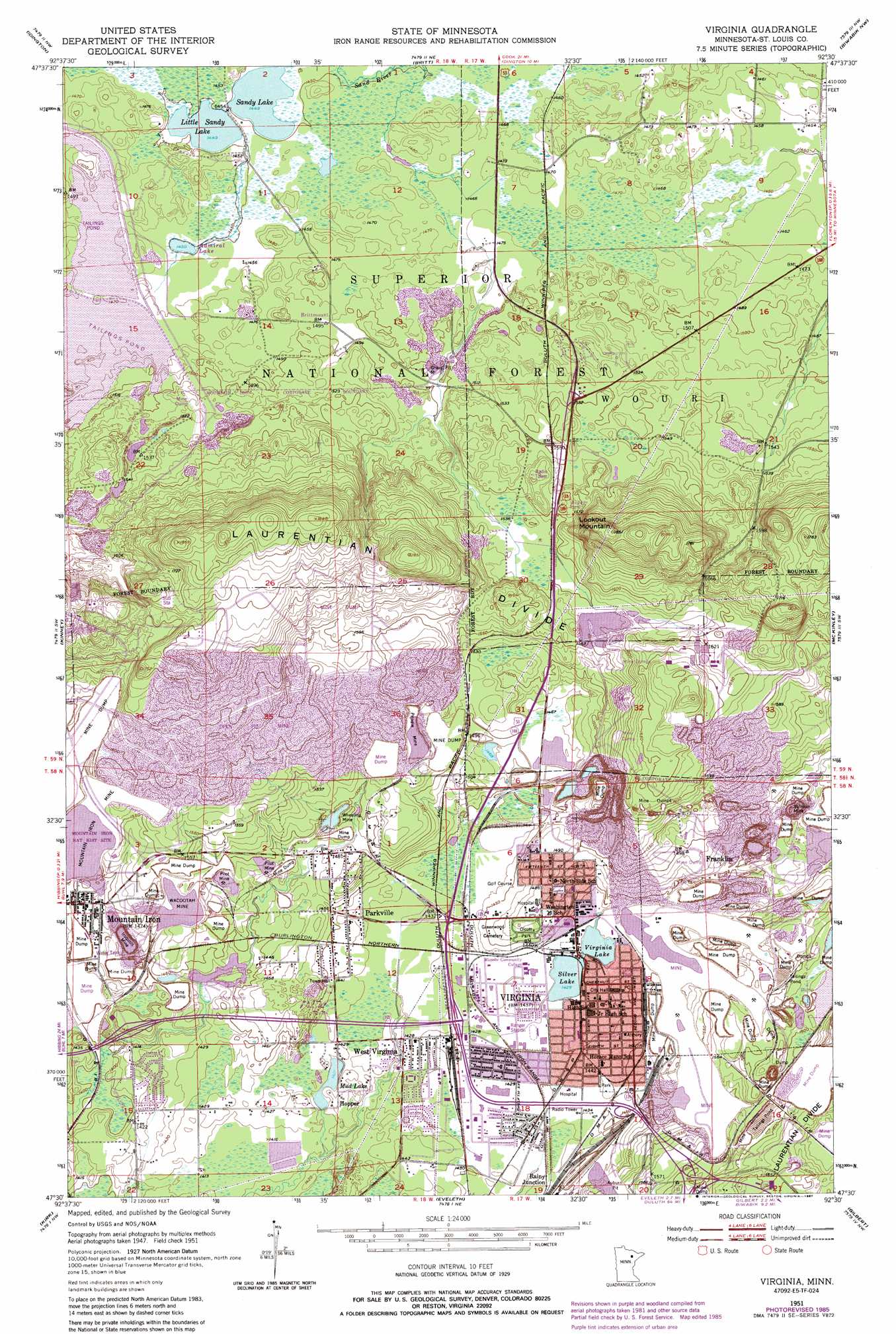
USGS Topo Quad 47092e5 - 1:24,000 scale
| Topo Map Name: | Virginia |
| USGS Topo Quad ID: | 47092e5 |
| Print Size: | ca. 21 1/4" wide x 27" high |
| Southeast Coordinates: | 47.5° N latitude / 92.5° W longitude |
| Map Center Coordinates: | 47.5625° N latitude / 92.5625° W longitude |
| U.S. State: | MN |
| Filename: | o47092e5.jpg |
| Download Map JPG Image: | Virginia topo map 1:24,000 scale |
| Map Type: | Topographic |
| Topo Series: | 7.5´ |
| Map Scale: | 1:24,000 |
| Source of Map Images: | United States Geological Survey (USGS) |
| Alternate Map Versions: |
Virginia MN 1951, updated 1952 Download PDF Buy paper map Virginia MN 1951, updated 1955 Download PDF Buy paper map Virginia MN 1951, updated 1966 Download PDF Buy paper map Virginia MN 1951, updated 1971 Download PDF Buy paper map Virginia MN 1951, updated 1983 Download PDF Buy paper map Virginia MN 1951, updated 1985 Download PDF Buy paper map Virginia MN 1951, updated 1987 Download PDF Buy paper map Virginia MN 2011 Download PDF Buy paper map Virginia MN 2013 Download PDF Buy paper map Virginia MN 2016 Download PDF Buy paper map |
| FStopo: | US Forest Service topo Virginia is available: Download FStopo PDF Download FStopo TIF |
1:24,000 Topo Quads surrounding Virginia
Linden Grove |
Cook |
Sassas Creek |
Lost Lake |
Tower |
Dark Lake |
Idington |
Britt |
Biwabik Nw |
Biwabik Ne |
Dewey Lake Se |
Kinney |
Virginia |
Mckinley |
Biwabik |
Buhl |
Kirk |
Eveleth |
Gilbert |
Palo |
Little Swan |
Casco |
Zim |
Central Lakes |
Makinen |
> Back to 47092e1 at 1:100,000 scale
> Back to 47092a1 at 1:250,000 scale
> Back to U.S. Topo Maps home
Virginia topo map: Gazetteer
Virginia: Dams
Plant Site Settling Dike elevation 490m 1607′Virginia: Lakes
Admiral Lake elevation 442m 1450′Little Sandy Lake elevation 442m 1450′
Mud Lake elevation 431m 1414′
Sandy Lake elevation 442m 1450′
Silver Lake elevation 434m 1423′
Virginia Lake elevation 434m 1423′
Virginia: Mines
Acootah Mine elevation 449m 1473′Alpena Mine elevation 461m 1512′
Higgins-McEwen Mine elevation 422m 1384′
Iroquois Mine elevation 447m 1466′
Minnewas Mine elevation 470m 1541′
Minorga Mine elevation 451m 1479′
Missabe Mountain Mine elevation 434m 1423′
Mountain Iron Mine elevation 453m 1486′
Ordean Mine elevation 430m 1410′
Pilot Mine elevation 453m 1486′
Pilot Mine elevation 450m 1476′
Prindle Mine elevation 483m 1584′
Rouchleau Mine elevation 457m 1499′
Sidney Mine elevation 515m 1689′
Sliver Mine elevation 429m 1407′
Sullivan Mine elevation 419m 1374′
Wacootah Mine elevation 449m 1473′
Wheeling Mine elevation 454m 1489′
Virginia: Parks
Laurentian Divide Geological Marker elevation 473m 1551′Laurentian Divide Superior National Forest Historical Marker elevation 473m 1551′
Mesabi Range Ore Discovery Historical Marker elevation 443m 1453′
Mountain Iron Mine Historical Marker elevation 443m 1453′
Olcott Park elevation 448m 1469′
Pepelnjak Southside Park elevation 440m 1443′
Virginia: Populated Places
Brittmount elevation 455m 1492′Franklin elevation 449m 1473′
Hopper elevation 437m 1433′
Mountain Iron elevation 452m 1482′
Parkville elevation 439m 1440′
Virginia elevation 439m 1440′
West Virginia elevation 435m 1427′
Virginia: Post Offices
Mountain Iron Post Office elevation 451m 1479′Parkville Post Office elevation 439m 1440′
Virginia Post Office elevation 442m 1450′
West Virginia Post Office (historical) elevation 435m 1427′
Virginia: Reservoirs
Plant Site Settling Basin elevation 490m 1607′Virginia: Ridges
Laurentian Divide elevation 560m 1837′Virginia: Summits
Lookout Mountain elevation 564m 1850′Virginia digital topo map on disk
Buy this Virginia topo map showing relief, roads, GPS coordinates and other geographical features, as a high-resolution digital map file on DVD: