Kinney Topo Map Minnesota
To zoom in, hover over the map of Kinney
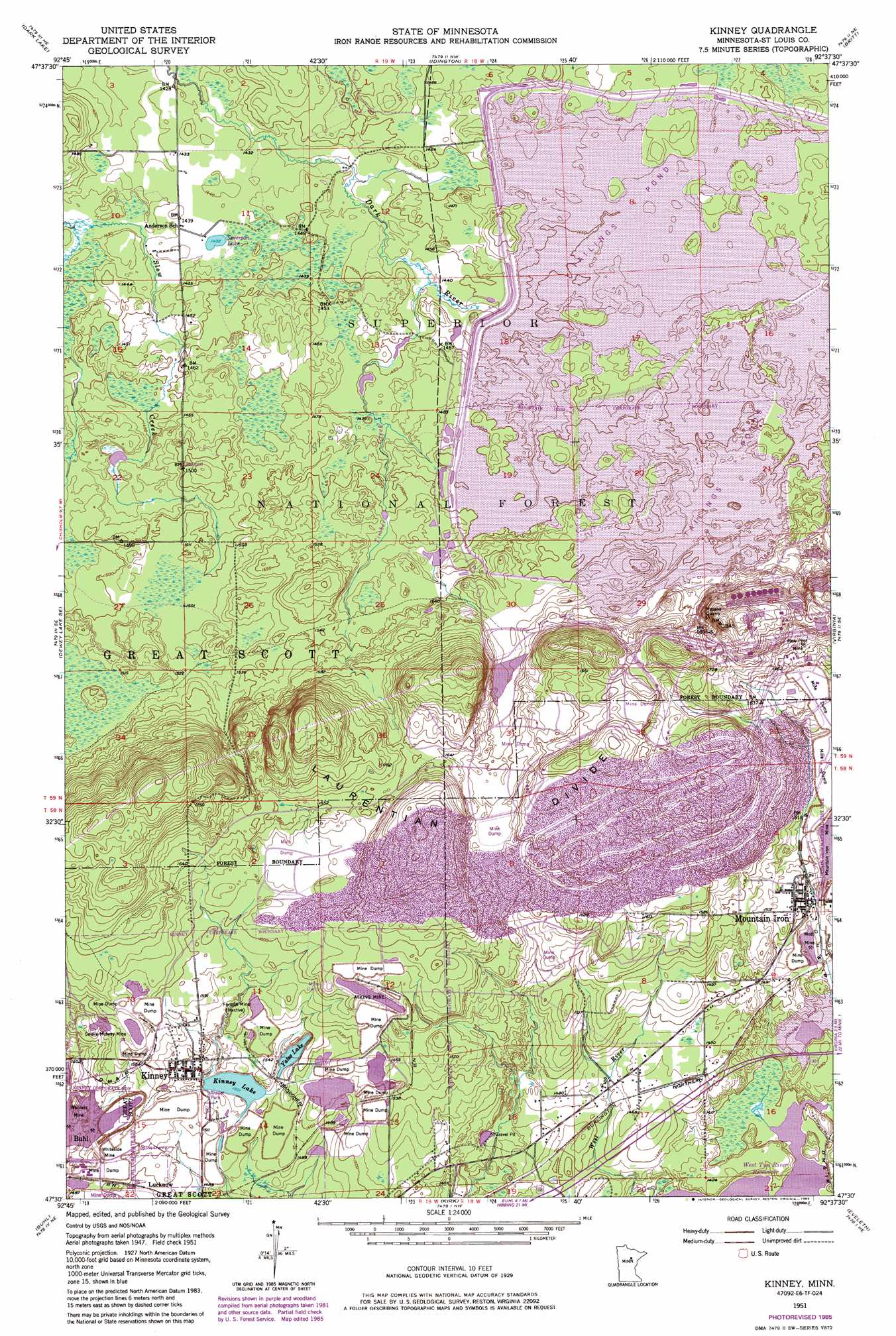
USGS Topo Quad 47092e6 - 1:24,000 scale
| Topo Map Name: | Kinney |
| USGS Topo Quad ID: | 47092e6 |
| Print Size: | ca. 21 1/4" wide x 27" high |
| Southeast Coordinates: | 47.5° N latitude / 92.625° W longitude |
| Map Center Coordinates: | 47.5625° N latitude / 92.6875° W longitude |
| U.S. State: | MN |
| Filename: | o47092e6.jpg |
| Download Map JPG Image: | Kinney topo map 1:24,000 scale |
| Map Type: | Topographic |
| Topo Series: | 7.5´ |
| Map Scale: | 1:24,000 |
| Source of Map Images: | United States Geological Survey (USGS) |
| Alternate Map Versions: |
Kinney MN 1951, updated 1952 Download PDF Buy paper map Kinney MN 1951, updated 1963 Download PDF Buy paper map Kinney MN 1951, updated 1971 Download PDF Buy paper map Kinney MN 1951, updated 1977 Download PDF Buy paper map Kinney MN 1951, updated 1983 Download PDF Buy paper map Kinney MN 1951, updated 1985 Download PDF Buy paper map Kinney MN 2011 Download PDF Buy paper map Kinney MN 2013 Download PDF Buy paper map Kinney MN 2016 Download PDF Buy paper map |
| FStopo: | US Forest Service topo Kinney is available: Download FStopo PDF Download FStopo TIF |
1:24,000 Topo Quads surrounding Kinney
Meadow Brook |
Linden Grove |
Cook |
Sassas Creek |
Lost Lake |
Dewey Lake Nw |
Dark Lake |
Idington |
Britt |
Biwabik Nw |
Dewey Lake |
Dewey Lake Se |
Kinney |
Virginia |
Mckinley |
Hibbing |
Buhl |
Kirk |
Eveleth |
Gilbert |
Riley |
Little Swan |
Casco |
Zim |
Central Lakes |
> Back to 47092e1 at 1:100,000 scale
> Back to 47092a1 at 1:250,000 scale
> Back to U.S. Topo Maps home
Kinney topo map: Gazetteer
Kinney: Dams
Minntac Tailings Dike elevation 466m 1528′Kinney: Lakes
Kinney Lake elevation 458m 1502′Severson Lake elevation 438m 1437′
Yates Lake elevation 459m 1505′
Kinney: Mines
Atkins Mine elevation 489m 1604′Forsyth Mine elevation 473m 1551′
Mesaba Quarry elevation 527m 1729′
Mott Mine elevation 441m 1446′
New Pilot Mine elevation 508m 1666′
Seville-Midway Mine elevation 488m 1601′
Wanless Mine elevation 447m 1466′
Whiteside Mine elevation 459m 1505′
Kinney: Populated Places
Kinney elevation 470m 1541′Lucknow elevation 455m 1492′
Kinney: Post Offices
Kinney Post Office elevation 470m 1541′Kinney: Reservoirs
Minntac Tailings Basin Cell One elevation 466m 1528′Kinney: Streams
McNiven Creek elevation 433m 1420′Timber Creek elevation 438m 1437′
Kinney digital topo map on disk
Buy this Kinney topo map showing relief, roads, GPS coordinates and other geographical features, as a high-resolution digital map file on DVD: