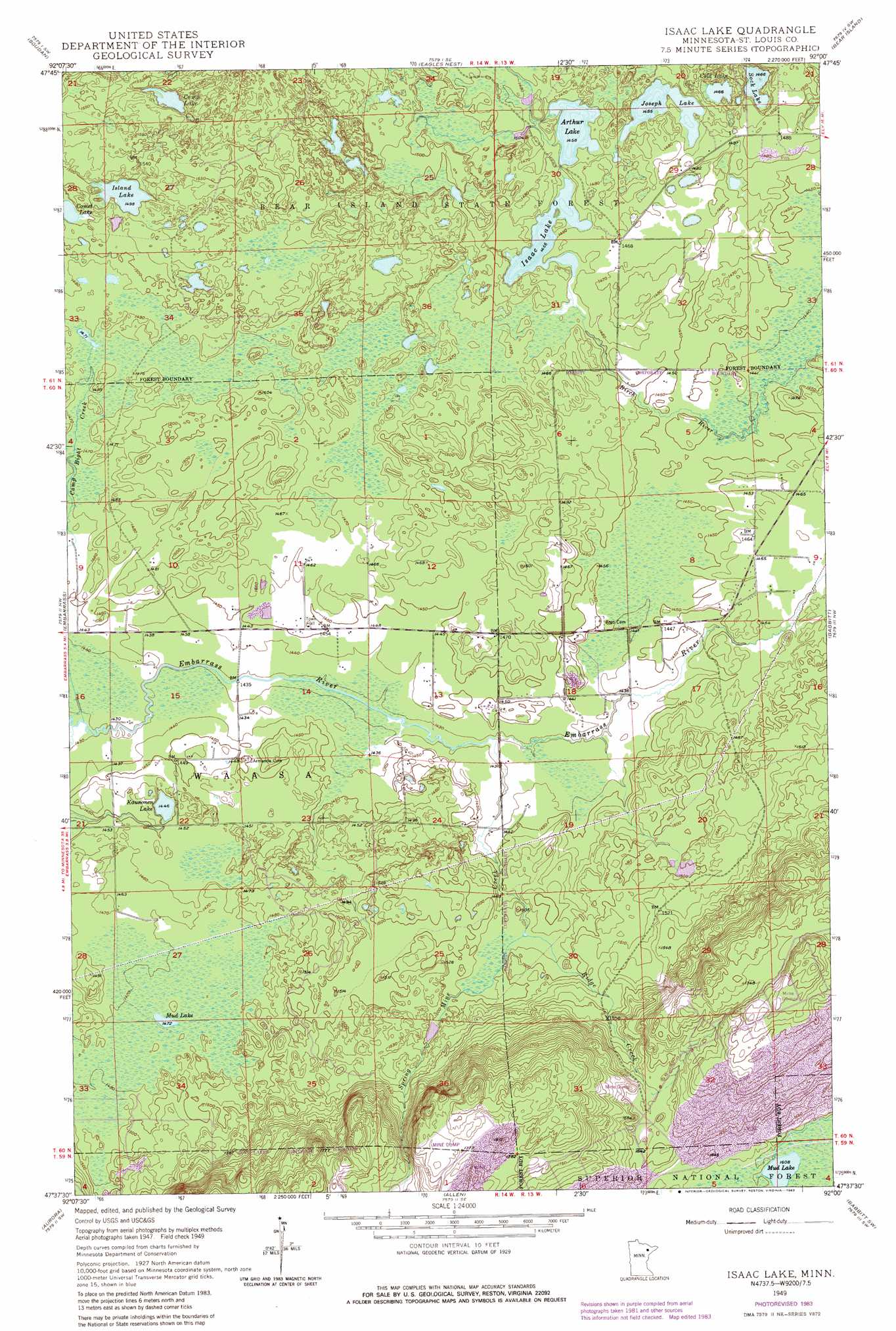
Isaac Lake Topo Map Minnesota
To zoom in, hover over the map of Isaac Lake
USGS Topo Quad 47092f1 - 1:24,000 scale
| Topo Map Name: | Isaac Lake |
| USGS Topo Quad ID: | 47092f1 |
| Print Size: | ca. 21 1/4" wide x 27" high |
| Southeast Coordinates: | 47.625° N latitude / 92° W longitude |
| Map Center Coordinates: | 47.6875° N latitude / 92.0625° W longitude |
| U.S. State: | MN |
| Filename: | o47092f1.jpg |
| Download Map JPG Image: | Isaac Lake topo map 1:24,000 scale |
| Map Type: | Topographic |
| Topo Series: | 7.5´ |
| Map Scale: | 1:24,000 |
| Source of Map Images: | United States Geological Survey (USGS) |
| Alternate Map Versions: |
Isaac Lake MN 1949, updated 1958 Download PDF Buy paper map Isaac Lake MN 1949, updated 1971 Download PDF Buy paper map Isaac Lake MN 1949, updated 1985 Download PDF Buy paper map Isaac Lake MN 1950 Download PDF Buy paper map Isaac Lake MN 2011 Download PDF Buy paper map Isaac Lake MN 2013 Download PDF Buy paper map Isaac Lake MN 2016 Download PDF Buy paper map |
| FStopo: | US Forest Service topo Isaac Lake is available: Download FStopo PDF Download FStopo TIF |
1:24,000 Topo Quads surrounding Isaac Lake
Sioux Pine Island |
Chad Lake |
Crab Lake |
Shagawa Lake |
Ely |
Tower |
Soudan |
Eagles Nest |
Bear Island |
Kangas Bay |
Biwabik Ne |
Embarrass |
Isaac Lake |
Babbitt |
Babbitt Ne |
Biwabik |
Aurora |
Allen |
Babbitt Sw |
Babbitt Se |
Palo |
Turpela Lake |
Bird Lake |
Skibo |
Toimi |
> Back to 47092e1 at 1:100,000 scale
> Back to 47092a1 at 1:250,000 scale
> Back to U.S. Topo Maps home
Isaac Lake topo map: Gazetteer
Isaac Lake: Lakes
Arthur Lake elevation 445m 1459′Camp Lake elevation 471m 1545′
Cold Lake elevation 447m 1466′
Isaac Lake elevation 444m 1456′
Island Lake elevation 457m 1499′
Joseph Lake elevation 447m 1466′
Kaunonen Lake elevation 441m 1446′
Mud Lake elevation 490m 1607′
Mud Lake elevation 449m 1473′
Sock Lake elevation 447m 1466′
Isaac Lake: Streams
Camp Eight Creek elevation 436m 1430′Ridge Creek elevation 453m 1486′
Spring Mine Creek elevation 436m 1430′
Isaac Lake digital topo map on disk
Buy this Isaac Lake topo map showing relief, roads, GPS coordinates and other geographical features, as a high-resolution digital map file on DVD: