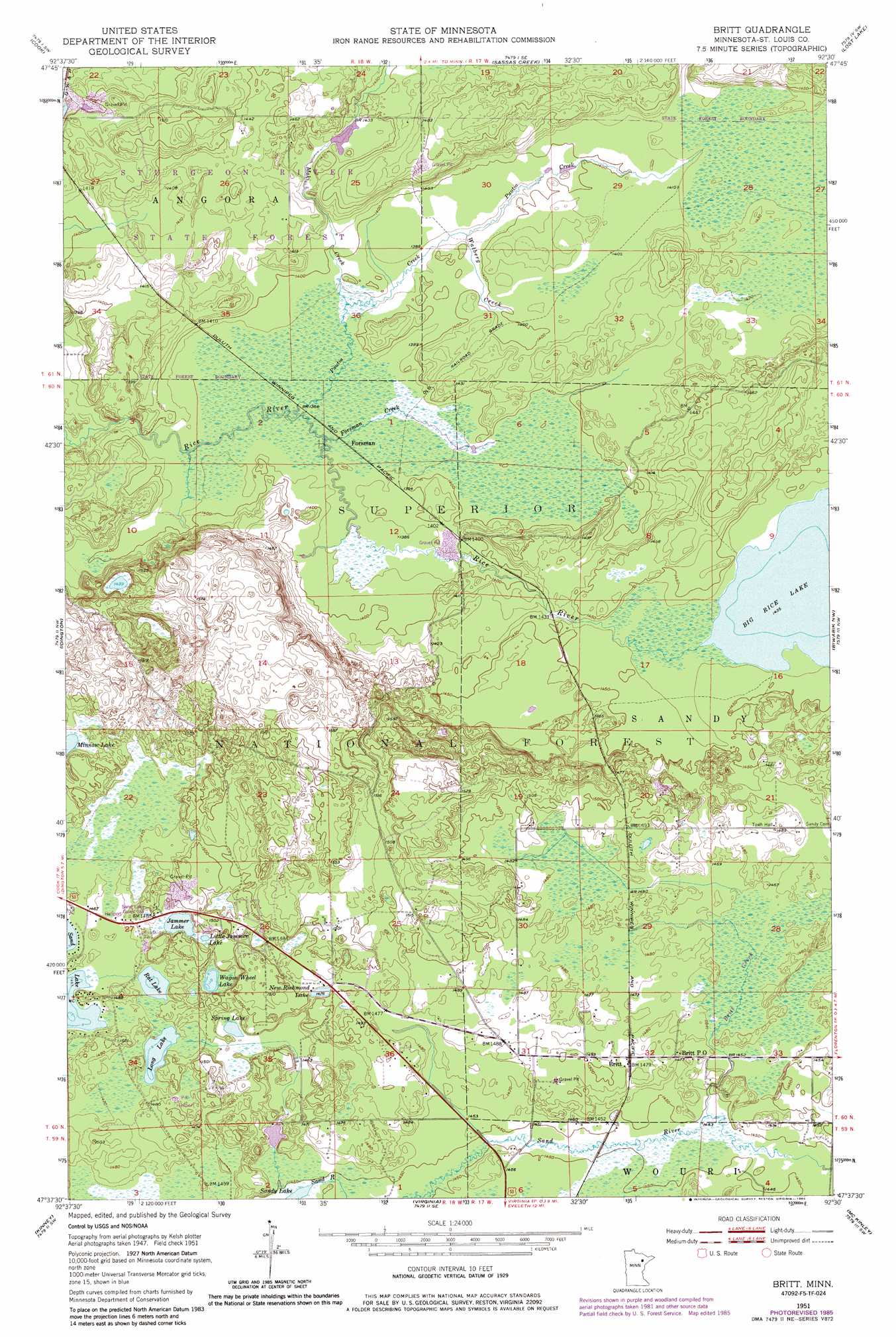
Britt Topo Map Minnesota
To zoom in, hover over the map of Britt
USGS Topo Quad 47092f5 - 1:24,000 scale
| Topo Map Name: | Britt |
| USGS Topo Quad ID: | 47092f5 |
| Print Size: | ca. 21 1/4" wide x 27" high |
| Southeast Coordinates: | 47.625° N latitude / 92.5° W longitude |
| Map Center Coordinates: | 47.6875° N latitude / 92.5625° W longitude |
| U.S. State: | MN |
| Filename: | o47092f5.jpg |
| Download Map JPG Image: | Britt topo map 1:24,000 scale |
| Map Type: | Topographic |
| Topo Series: | 7.5´ |
| Map Scale: | 1:24,000 |
| Source of Map Images: | United States Geological Survey (USGS) |
| Alternate Map Versions: |
Britt MN 1951, updated 1953 Download PDF Buy paper map Britt MN 1951, updated 1966 Download PDF Buy paper map Britt MN 1951, updated 1971 Download PDF Buy paper map Britt MN 1951, updated 1985 Download PDF Buy paper map Britt MN 2011 Download PDF Buy paper map Britt MN 2013 Download PDF Buy paper map Britt MN 2016 Download PDF Buy paper map |
| FStopo: | US Forest Service topo Britt is available: Download FStopo PDF Download FStopo TIF |
1:24,000 Topo Quads surrounding Britt
Gheen |
Haley |
Norwegian Bay |
Vermilion Dam |
Sioux Pine Island |
Linden Grove |
Cook |
Sassas Creek |
Lost Lake |
Tower |
Dark Lake |
Idington |
Britt |
Biwabik Nw |
Biwabik Ne |
Dewey Lake Se |
Kinney |
Virginia |
Mckinley |
Biwabik |
Buhl |
Kirk |
Eveleth |
Gilbert |
Palo |
> Back to 47092e1 at 1:100,000 scale
> Back to 47092a1 at 1:250,000 scale
> Back to U.S. Topo Maps home
Britt topo map: Gazetteer
Britt: Channels
Wakemup Narrows elevation 448m 1469′Britt: Lakes
Jammer Lake elevation 451m 1479′Little Jammer Lake elevation 451m 1479′
Minnow Lake elevation 447m 1466′
Mulden Lake elevation 447m 1466′
New Richmond Lake elevation 450m 1476′
Rat Lake elevation 447m 1466′
Spring Lake elevation 447m 1466′
Wagon Wheel Lake elevation 450m 1476′
Britt: Populated Places
Britt elevation 450m 1476′Forsman elevation 422m 1384′
Britt: Post Offices
Britt Post Office elevation 451m 1479′Britt: Streams
Britt Creek elevation 442m 1450′Forsman Creek elevation 421m 1381′
Maki Creek elevation 423m 1387′
Puutio Creek elevation 421m 1381′
Walberg Creek elevation 424m 1391′
Britt digital topo map on disk
Buy this Britt topo map showing relief, roads, GPS coordinates and other geographical features, as a high-resolution digital map file on DVD: