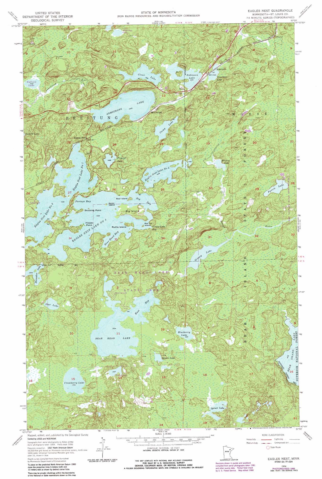
Eagles Nest Topo Map Minnesota
To zoom in, hover over the map of Eagles Nest
USGS Topo Quad 47092g1 - 1:24,000 scale
| Topo Map Name: | Eagles Nest |
| USGS Topo Quad ID: | 47092g1 |
| Print Size: | ca. 21 1/4" wide x 27" high |
| Southeast Coordinates: | 47.75° N latitude / 92° W longitude |
| Map Center Coordinates: | 47.8125° N latitude / 92.0625° W longitude |
| U.S. State: | MN |
| Filename: | o47092g1.jpg |
| Download Map JPG Image: | Eagles Nest topo map 1:24,000 scale |
| Map Type: | Topographic |
| Topo Series: | 7.5´ |
| Map Scale: | 1:24,000 |
| Source of Map Images: | United States Geological Survey (USGS) |
| Alternate Map Versions: |
Eagles Nest MN 1956, updated 1958 Download PDF Buy paper map Eagles Nest MN 1956, updated 1961 Download PDF Buy paper map Eagles Nest MN 1956, updated 1971 Download PDF Buy paper map Eagles Nest MN 1956, updated 1977 Download PDF Buy paper map Eagles Nest MN 1956, updated 1986 Download PDF Buy paper map Eagles Nest MN 2011 Download PDF Buy paper map Eagles Nest MN 2013 Download PDF Buy paper map Eagles Nest MN 2016 Download PDF Buy paper map |
| FStopo: | US Forest Service topo Eagles Nest is available: Download FStopo PDF Download FStopo TIF |
1:24,000 Topo Quads surrounding Eagles Nest
Astrid Lake |
Bootleg Lake |
Lapond Lake |
Angleworm Lake |
Fourtown Lake |
Sioux Pine Island |
Chad Lake |
Crab Lake |
Shagawa Lake |
Ely |
Tower |
Soudan |
Eagles Nest |
Bear Island |
Kangas Bay |
Biwabik Ne |
Embarrass |
Isaac Lake |
Babbitt |
Babbitt Ne |
Biwabik |
Aurora |
Allen |
Babbitt Sw |
Babbitt Se |
> Back to 47092e1 at 1:100,000 scale
> Back to 47092a1 at 1:250,000 scale
> Back to U.S. Topo Maps home
Eagles Nest topo map: Gazetteer
Eagles Nest: Bays
Bear Head Bay elevation 455m 1492′Big Bay elevation 455m 1492′
East Bay elevation 459m 1505′
Grassy Lake Bay elevation 455m 1492′
Portage Bay elevation 455m 1492′
Eagles Nest: Capes
Howes Point elevation 458m 1502′Stocking Point elevation 461m 1512′
Eagles Nest: Islands
Bear Island elevation 461m 1512′Big Island elevation 458m 1502′
Big Toe Island elevation 460m 1509′
Burnt Island elevation 457m 1499′
Ruths Island elevation 465m 1525′
Eagles Nest: Lakes
Armstrong Lake elevation 444m 1456′Bear Head Lake elevation 459m 1505′
Blueberry Lake elevation 455m 1492′
Camp Lake elevation 458m 1502′
Clear Lake elevation 455m 1492′
Cranberry Lake elevation 459m 1505′
Deadman Lake elevation 450m 1476′
Eagles Nest Lake Number 2 elevation 454m 1489′
Eagles Nest Lake Number Four elevation 456m 1496′
Eagles Nest Lake Number One elevation 454m 1489′
Eagles Nest Lake Number Three elevation 455m 1492′
Gafvert Lake elevation 430m 1410′
Grassy Lake elevation 438m 1437′
Holter Lake elevation 460m 1509′
Horseshoe Lake elevation 460m 1509′
Meadow Lake elevation 456m 1496′
Nickolson Lake elevation 459m 1505′
Pickerel Lake elevation 454m 1489′
Purvis Lake elevation 456m 1496′
Robinson Lake elevation 450m 1476′
Spruce Lake elevation 453m 1486′
Square Lake elevation 457m 1499′
Star Lake elevation 465m 1525′
Toikka Lake elevation 447m 1466′
Eagles Nest: Parks
Bear Head Lake State Park elevation 459m 1505′Purvis Ober State Natural Area elevation 465m 1525′
Eagles Nest: Populated Places
Eagles Nest elevation 454m 1489′McComber elevation 448m 1469′
Robinson elevation 451m 1479′
Eagles Nest: Post Offices
McComber Post Office (historical) elevation 448m 1469′Eagles Nest digital topo map on disk
Buy this Eagles Nest topo map showing relief, roads, GPS coordinates and other geographical features, as a high-resolution digital map file on DVD: