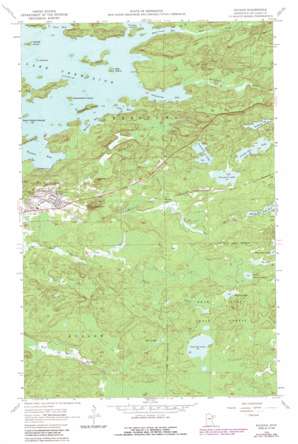
Soudan Topo Map Minnesota
To zoom in, hover over the map of Soudan
USGS Topo Quad 47092g2 - 1:24,000 scale
| Topo Map Name: | Soudan |
| USGS Topo Quad ID: | 47092g2 |
| Print Size: | ca. 21 1/4" wide x 27" high |
| Southeast Coordinates: | 47.75° N latitude / 92.125° W longitude |
| Map Center Coordinates: | 47.8125° N latitude / 92.1875° W longitude |
| U.S. State: | MN |
| Filename: | o47092g2.jpg |
| Download Map JPG Image: | Soudan topo map 1:24,000 scale |
| Map Type: | Topographic |
| Topo Series: | 7.5´ |
| Map Scale: | 1:24,000 |
| Source of Map Images: | United States Geological Survey (USGS) |
| Alternate Map Versions: |
Soudan MN 1956, updated 1958 Download PDF Buy paper map Soudan MN 1956, updated 1960 Download PDF Buy paper map Soudan MN 1956, updated 1971 Download PDF Buy paper map Soudan MN 1956, updated 1974 Download PDF Buy paper map Soudan MN 1956, updated 1986 Download PDF Buy paper map Soudan MN 2010 Download PDF Buy paper map Soudan MN 2013 Download PDF Buy paper map Soudan MN 2016 Download PDF Buy paper map |
| FStopo: | US Forest Service topo Soudan is available: Download FStopo PDF Download FStopo TIF |
1:24,000 Topo Quads surrounding Soudan
> Back to 47092e1 at 1:100,000 scale
> Back to 47092a1 at 1:250,000 scale
> Back to U.S. Topo Maps home
Soudan topo map: Gazetteer
Soudan: Bays
Armstrong Bay elevation 414m 1358′Cable Bay elevation 414m 1358′
Mattson Bay elevation 414m 1358′
Mud Creek Bay elevation 414m 1358′
Stuntz Bay elevation 414m 1358′
Soudan: Islands
Birch Island elevation 425m 1394′Dog Island elevation 425m 1394′
Hendrickson Island elevation 426m 1397′
J B Island elevation 419m 1374′
Long Island elevation 424m 1391′
Nyberg Island elevation 419m 1374′
Raspberry Island elevation 431m 1414′
Seven Sisters Islands elevation 421m 1381′
Timber Island elevation 424m 1391′
Soudan: Lakes
Fivemile Lake elevation 443m 1453′Fourmile Lake elevation 445m 1459′
Little Skeleton Lake elevation 458m 1502′
Moose Lake elevation 462m 1515′
Needle Boy Lake elevation 451m 1479′
Putnam Lake elevation 452m 1482′
Sixmile Lake elevation 457m 1499′
Skeleton Lake elevation 455m 1492′
Tee Lake elevation 459m 1505′
Soudan: Mines
LaRue Mine elevation 439m 1440′Soudan Mine elevation 488m 1601′
Soudan: Parks
Jasper Peak Wayside Park elevation 459m 1505′Soudan Mine Historical Marker elevation 430m 1410′
Soudan Underground Mine Park elevation 481m 1578′
Soudan: Populated Places
Murray elevation 440m 1443′Soudan elevation 437m 1433′
Soudan: Post Offices
Soudan Post Office elevation 447m 1466′Soudan: Streams
Armstrong River elevation 414m 1358′Mud Creek elevation 414m 1358′
Owens Creek elevation 430m 1410′
Soudan: Summits
Jasper Peak elevation 519m 1702′Soudan digital topo map on disk
Buy this Soudan topo map showing relief, roads, GPS coordinates and other geographical features, as a high-resolution digital map file on DVD:


