Wabana Lake Topo Map Minnesota
To zoom in, hover over the map of Wabana Lake
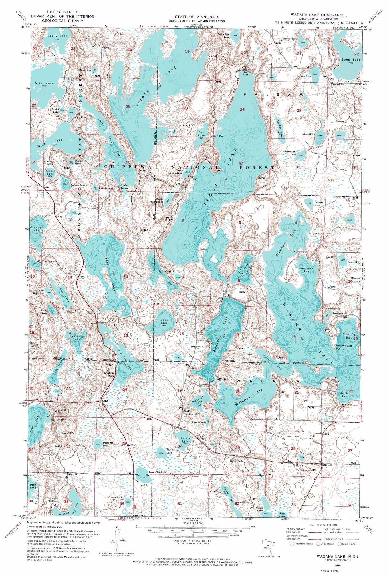
USGS Topo Quad 47093d5 - 1:24,000 scale
| Topo Map Name: | Wabana Lake |
| USGS Topo Quad ID: | 47093d5 |
| Print Size: | ca. 21 1/4" wide x 27" high |
| Southeast Coordinates: | 47.375° N latitude / 93.5° W longitude |
| Map Center Coordinates: | 47.4375° N latitude / 93.5625° W longitude |
| U.S. State: | MN |
| Filename: | o47093d5.jpg |
| Download Map JPG Image: | Wabana Lake topo map 1:24,000 scale |
| Map Type: | Topographic |
| Topo Series: | 7.5´ |
| Map Scale: | 1:24,000 |
| Source of Map Images: | United States Geological Survey (USGS) |
| Alternate Map Versions: |
Wabana Lake MN 1970, updated 1973 Download PDF Buy paper map Wabana Lake MN 1970, updated 1989 Download PDF Buy paper map Wabana Lake MN 1996, updated 1998 Download PDF Buy paper map Wabana Lake MN 2011 Download PDF Buy paper map Wabana Lake MN 2013 Download PDF Buy paper map Wabana Lake MN 2016 Download PDF Buy paper map |
| FStopo: | US Forest Service topo Wabana Lake is available: Download FStopo PDF Download FStopo TIF |
1:24,000 Topo Quads surrounding Wabana Lake
Spring Lake |
Bigfork |
Coon Lake |
Anderson Lake |
Horsehead Lake |
Jessie Lake |
Marcell |
Clubhouse Lake |
Balsam Lake |
Hartley Lake |
Deer River Ne |
Little Bowstring Lake |
Wabana Lake |
Lawrence Lake West |
Lawrence Lake East |
Deer River |
Cohasset West |
Cohasset East |
Bovey |
Calumet |
Sugar Lake |
Siseebakwet Lake |
Grand Rapids |
La Prairie |
Warba |
> Back to 47093a1 at 1:100,000 scale
> Back to 47092a1 at 1:250,000 scale
> Back to U.S. Topo Maps home
Wabana Lake topo map: Gazetteer
Wabana Lake: Bays
Birch Bay elevation 402m 1318′Buckman Cove elevation 402m 1318′
Murphy Bay elevation 402m 1318′
Pickerel Bay elevation 402m 1318′
Simmons Bay elevation 402m 1318′
Wakeman Bay elevation 402m 1318′
Wabana Lake: Capes
Arrowhead Point elevation 404m 1325′Wabana Lake: Lakes
Beaver Lake elevation 419m 1374′Beaver Lake elevation 420m 1377′
Beavertail Lake elevation 429m 1407′
Bee Cee Lake elevation 430m 1410′
Big Horn Lake elevation 423m 1387′
Bluebill Lake elevation 413m 1354′
Bluebill Pond elevation 416m 1364′
Bluewater Lake elevation 402m 1318′
Bobby Lake elevation 417m 1368′
Bosely Lake elevation 410m 1345′
Buhella Lake elevation 402m 1318′
Circle Lake elevation 419m 1374′
Day Lake elevation 414m 1358′
Dead Horse Lake elevation 414m 1358′
Doan Lake elevation 418m 1371′
Francis Lake elevation 428m 1404′
Hill Lake elevation 420m 1377′
Irma Lake elevation 417m 1368′
Johnson Lake elevation 415m 1361′
Lake Charlotte elevation 418m 1371′
Lawrence Lake elevation 411m 1348′
Little Bear Lake elevation 421m 1381′
Little Long Lake elevation 416m 1364′
Little Trout Lake elevation 402m 1318′
Little Wolf Lake elevation 417m 1368′
Long Lake elevation 412m 1351′
Lower Spring Lake elevation 406m 1332′
Lucky Lake elevation 412m 1351′
Moonshine Lake elevation 423m 1387′
Moore Lake elevation 414m 1358′
Orange Lake elevation 426m 1397′
Otter Lake elevation 428m 1404′
Pickerel Lake elevation 403m 1322′
Pug Hole Lake elevation 410m 1345′
Roland Lake elevation 422m 1384′
Sand Lake elevation 415m 1361′
Shelly Lake elevation 419m 1374′
Snowshoe Lake elevation 416m 1364′
Spider Lake elevation 416m 1364′
Spring Lake elevation 402m 1318′
Spruce Lake elevation 404m 1325′
Sunrise Lake elevation 416m 1364′
Trout Lake elevation 402m 1318′
Twin Lake elevation 408m 1338′
Upper Spring Lake elevation 406m 1332′
Wabana Lake elevation 402m 1318′
Wolf Lake elevation 416m 1364′
Wabana Lake: Parks
Pug Hole Lake Wayside Park elevation 410m 1345′Trout Lake Management Area elevation 411m 1348′
Wabana Lake: Post Offices
Leoneth Post Office (historical) elevation 427m 1400′Wabana Lake: Reservoirs
Wabana Impoundment elevation 404m 1325′Wabana Lake digital topo map on disk
Buy this Wabana Lake topo map showing relief, roads, GPS coordinates and other geographical features, as a high-resolution digital map file on DVD: