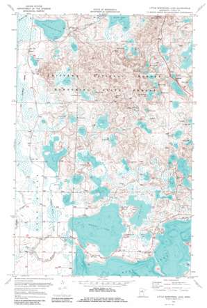
Little Bowstring Lake Topo Map Minnesota
To zoom in, hover over the map of Little Bowstring Lake
USGS Topo Quad 47093d6 - 1:24,000 scale
| Topo Map Name: | Little Bowstring Lake |
| USGS Topo Quad ID: | 47093d6 |
| Print Size: | ca. 21 1/4" wide x 27" high |
| Southeast Coordinates: | 47.375° N latitude / 93.625° W longitude |
| Map Center Coordinates: | 47.4375° N latitude / 93.6875° W longitude |
| U.S. State: | MN |
| Filename: | o47093d6.jpg |
| Download Map JPG Image: | Little Bowstring Lake topo map 1:24,000 scale |
| Map Type: | Topographic |
| Topo Series: | 7.5´ |
| Map Scale: | 1:24,000 |
| Source of Map Images: | United States Geological Survey (USGS) |
| Alternate Map Versions: |
Little Bowstring Lake MN 1970, updated 1973 Download PDF Buy paper map Little Bowstring Lake MN 1970, updated 1985 Download PDF Buy paper map Little Bowstring Lake MN 1996, updated 1998 Download PDF Buy paper map Little Bowstring Lake MN 2011 Download PDF Buy paper map Little Bowstring Lake MN 2013 Download PDF Buy paper map Little Bowstring Lake MN 2016 Download PDF Buy paper map |
| FStopo: | US Forest Service topo Little Bowstring Lake is available: Download FStopo PDF Download FStopo TIF |
1:24,000 Topo Quads surrounding Little Bowstring Lake
> Back to 47093a1 at 1:100,000 scale
> Back to 47092a1 at 1:250,000 scale
> Back to U.S. Topo Maps home
Little Bowstring Lake topo map: Gazetteer
Little Bowstring Lake: Dams
Deer Lake Dam elevation 399m 1309′Little Bowstring Lake: Lakes
Adele Lake elevation 416m 1364′Alex Lake elevation 402m 1318′
Alp Lake elevation 416m 1364′
Amen Lake elevation 411m 1348′
Balloon Lake elevation 415m 1361′
Bay Lake elevation 399m 1309′
Beaver Lake elevation 430m 1410′
Beaver Lake elevation 416m 1364′
Big Green Lake elevation 416m 1364′
Boiler Lake elevation 415m 1361′
Camp Five Lakes elevation 404m 1325′
Carpenter Lake elevation 418m 1371′
Cottonwood Lake elevation 401m 1315′
Cranberry Lake elevation 411m 1348′
Crane Lake elevation 408m 1338′
Dalton Lake elevation 408m 1338′
Day Lake elevation 434m 1423′
Deer Lake elevation 399m 1309′
Doam Lake elevation 401m 1315′
Doctor Lake elevation 416m 1364′
Edd Lake elevation 401m 1315′
Fawn Lake elevation 399m 1309′
Forjer Lake elevation 422m 1384′
Green Lake elevation 402m 1318′
Hanson Lake elevation 402m 1318′
Hooligan Lake elevation 414m 1358′
Island Lake elevation 401m 1315′
Jim Lake elevation 404m 1325′
Kremer Lake elevation 417m 1368′
Lee Lake elevation 444m 1456′
Little Bowstring Lake elevation 405m 1328′
Little Cottonwood Lake elevation 405m 1328′
Little Horn Lake elevation 432m 1417′
Little Moose Lake elevation 399m 1309′
Maki Lake elevation 404m 1325′
McDonald Lake elevation 407m 1335′
Miller Lake elevation 428m 1404′
Moore Lake elevation 426m 1397′
Moose Lake elevation 399m 1309′
Mud Lake elevation 414m 1358′
Myers Lake elevation 416m 1364′
Mystery Lake elevation 428m 1404′
Otter Lake elevation 401m 1315′
Oxbow Lake elevation 428m 1404′
Pickerel Lake elevation 408m 1338′
Pothole Lake elevation 416m 1364′
Poverty Lake elevation 404m 1325′
Spruce Island Lake elevation 415m 1361′
Suomi Lake elevation 413m 1354′
Surprise Lake elevation 419m 1374′
Little Bowstring Lake: Parks
Suomi Hills Recreation Area elevation 446m 1463′Surprise Lake Wayside Park elevation 441m 1446′
Little Bowstring Lake: Populated Places
Suomi elevation 414m 1358′Little Bowstring Lake: Post Offices
Suomi Post Office (historical) elevation 415m 1361′Little Bowstring Lake: Streams
Island Lake Creek elevation 397m 1302′Little Bowstring Lake: Trails
Suomi Hills Trail System elevation 446m 1463′Little Bowstring Lake digital topo map on disk
Buy this Little Bowstring Lake topo map showing relief, roads, GPS coordinates and other geographical features, as a high-resolution digital map file on DVD:


