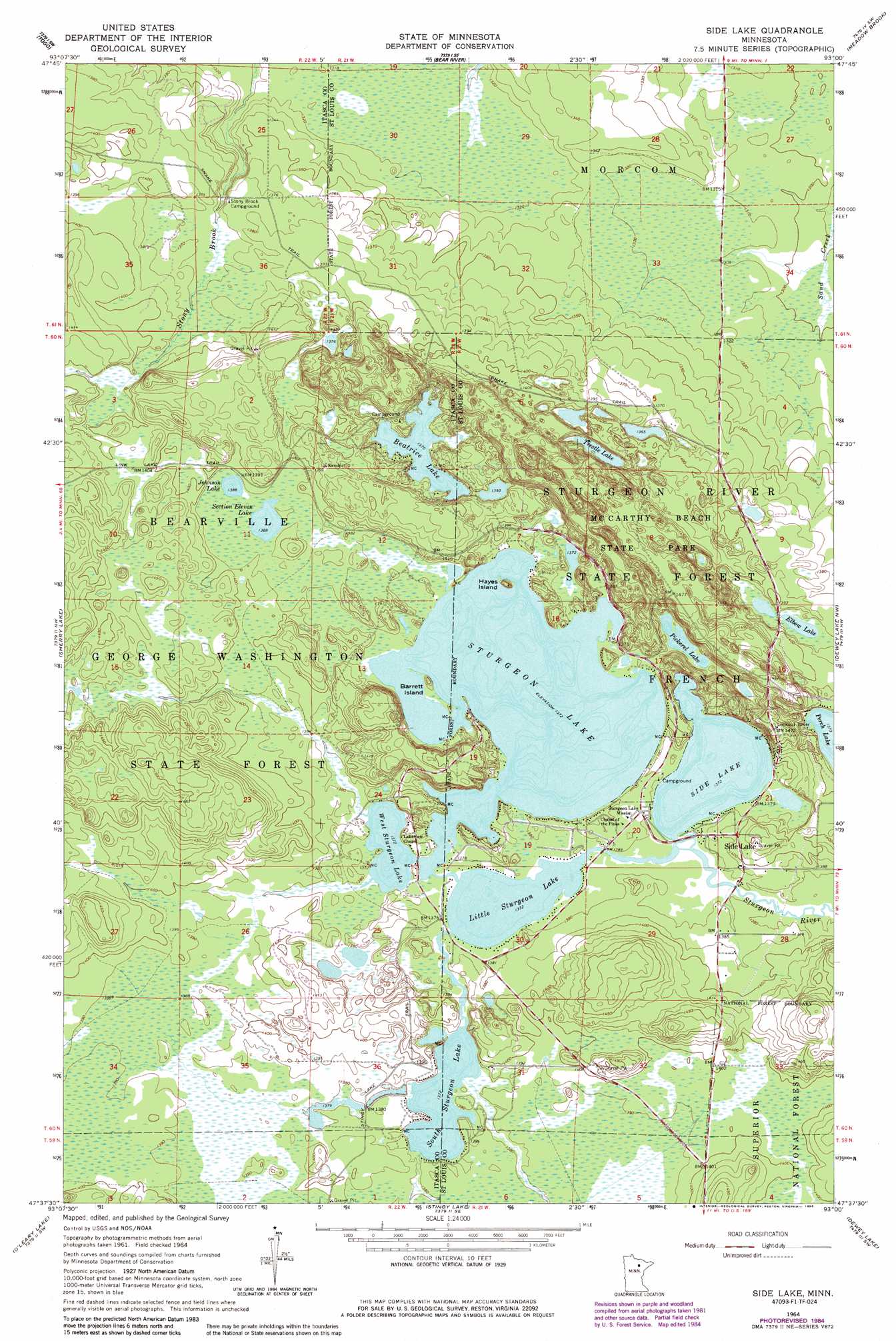
Side Lake Topo Map Minnesota
To zoom in, hover over the map of Side Lake
USGS Topo Quad 47093f1 - 1:24,000 scale
| Topo Map Name: | Side Lake |
| USGS Topo Quad ID: | 47093f1 |
| Print Size: | ca. 21 1/4" wide x 27" high |
| Southeast Coordinates: | 47.625° N latitude / 93° W longitude |
| Map Center Coordinates: | 47.6875° N latitude / 93.0625° W longitude |
| U.S. State: | MN |
| Filename: | o47093f1.jpg |
| Download Map JPG Image: | Side Lake topo map 1:24,000 scale |
| Map Type: | Topographic |
| Topo Series: | 7.5´ |
| Map Scale: | 1:24,000 |
| Source of Map Images: | United States Geological Survey (USGS) |
| Alternate Map Versions: |
Side Lake MN 1964, updated 1965 Download PDF Buy paper map Side Lake MN 1964, updated 1971 Download PDF Buy paper map Side Lake MN 1964, updated 1985 Download PDF Buy paper map Side Lake MN 2011 Download PDF Buy paper map Side Lake MN 2013 Download PDF Buy paper map Side Lake MN 2016 Download PDF Buy paper map |
| FStopo: | US Forest Service topo Side Lake is available: Download FStopo PDF Download FStopo TIF |
1:24,000 Topo Quads surrounding Side Lake
Deer Lake Ne |
Rauch |
Silverdale |
Gheen Nw |
Gheen |
Deer Lake East |
Togo |
Bear River |
Meadow Brook |
Linden Grove |
Horsehead Lake |
Sherry Lake |
Side Lake |
Dewey Lake Nw |
Dark Lake |
Hartley Lake |
O'Leary Lake |
Stingy Lake |
Dewey Lake |
Dewey Lake Se |
Lawrence Lake East |
Nashwauk |
Keewatin |
Hibbing |
Buhl |
> Back to 47093e1 at 1:100,000 scale
> Back to 47092a1 at 1:250,000 scale
> Back to U.S. Topo Maps home
Side Lake topo map: Gazetteer
Side Lake: Airports
Christenson Point Seaplane Base elevation 422m 1384′Sixberrys Landing Seaplane Base elevation 418m 1371′
Side Lake: Dams
Sturgeon Lake Dam elevation 418m 1371′Side Lake: Islands
Barrett Island elevation 421m 1381′Hayes Island elevation 429m 1407′
Side Lake: Lakes
Beatrice Lake elevation 418m 1371′Elbow Lake elevation 421m 1381′
Johnson Lake elevation 423m 1387′
Little Sturgeon Lake elevation 418m 1371′
Pickerel Lake elevation 419m 1374′
Section Eleven Lake elevation 423m 1387′
Side Lake elevation 418m 1371′
South Sturgeon Lake elevation 418m 1371′
Sturgeon Lake elevation 418m 1371′
Trestle Lake elevation 416m 1364′
West Sturgeon Lake elevation 418m 1371′
Side Lake: Parks
McCarthy Beach State Park elevation 421m 1381′Origin of McCarthy Beach Geological Marker elevation 448m 1469′
Side Lake: Populated Places
Side Lake elevation 427m 1400′Side Lake: Post Offices
Side Lake Post Office elevation 427m 1400′Side Lake: Reservoirs
Sturgeon Lake elevation 418m 1371′Side Lake: Trails
Link Lake Trail elevation 426m 1397′Snake Trail elevation 428m 1404′
Stingy Lake Trail elevation 424m 1391′
Side Lake digital topo map on disk
Buy this Side Lake topo map showing relief, roads, GPS coordinates and other geographical features, as a high-resolution digital map file on DVD: