Spring Lake Topo Map Minnesota
To zoom in, hover over the map of Spring Lake
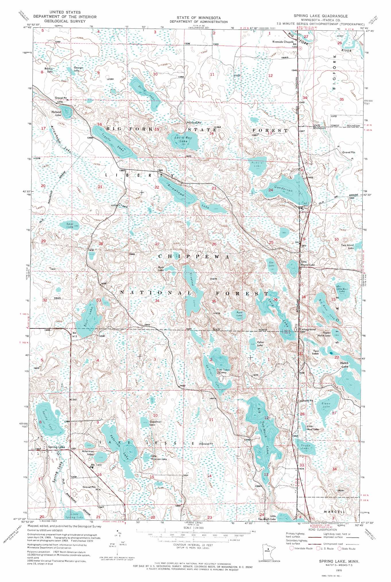
USGS Topo Quad 47093f7 - 1:24,000 scale
| Topo Map Name: | Spring Lake |
| USGS Topo Quad ID: | 47093f7 |
| Print Size: | ca. 21 1/4" wide x 27" high |
| Southeast Coordinates: | 47.625° N latitude / 93.75° W longitude |
| Map Center Coordinates: | 47.6875° N latitude / 93.8125° W longitude |
| U.S. State: | MN |
| Filename: | o47093f7.jpg |
| Download Map JPG Image: | Spring Lake topo map 1:24,000 scale |
| Map Type: | Topographic |
| Topo Series: | 7.5´ |
| Map Scale: | 1:24,000 |
| Source of Map Images: | United States Geological Survey (USGS) |
| Alternate Map Versions: |
Spring Lake MN 1970, updated 1973 Download PDF Buy paper map Spring Lake MN 1970, updated 1986 Download PDF Buy paper map Spring Lake MN 1996, updated 1998 Download PDF Buy paper map Spring Lake MN 2011 Download PDF Buy paper map Spring Lake MN 2013 Download PDF Buy paper map Spring Lake MN 2016 Download PDF Buy paper map |
| FStopo: | US Forest Service topo Spring Lake is available: Download FStopo PDF Download FStopo TIF |
1:24,000 Topo Quads surrounding Spring Lake
Mizpah Ne |
Wildwood |
Wildwood Ne |
Effie Nw |
Craigville |
Coddington Lake |
Pomroy |
Wildwood Se |
Effie |
Effie Se |
Dora Lake |
Wirt |
Spring Lake |
Bigfork |
Coon Lake |
Max |
Bowstring Lake |
Jessie Lake |
Marcell |
Clubhouse Lake |
Little Winnibigoshish Lake |
Little Ball Club Lake |
Deer River Ne |
Little Bowstring Lake |
Wabana Lake |
> Back to 47093e1 at 1:100,000 scale
> Back to 47092a1 at 1:250,000 scale
> Back to U.S. Topo Maps home
Spring Lake topo map: Gazetteer
Spring Lake: Dams
East Lake Dam elevation 425m 1394′Spring Lake: Lakes
Ackerman Lakes elevation 426m 1397′Arrowhead Lake elevation 419m 1374′
Backus Lake elevation 412m 1351′
Big Rose Lake elevation 417m 1368′
Big Too Much Lake elevation 414m 1358′
Boggy Lake elevation 420m 1377′
Crooked Lake elevation 424m 1391′
David Lake elevation 409m 1341′
East Lake elevation 425m 1394′
Elbow Lake elevation 421m 1381′
Elm Lake elevation 415m 1361′
Fisher Lake elevation 431m 1414′
George Lake elevation 411m 1348′
Goodman Lake elevation 428m 1404′
Gunderson Lake elevation 420m 1377′
Hatch Lake elevation 412m 1351′
Holland Lake elevation 411m 1348′
Lac-a-Roy Lake elevation 418m 1371′
LaCroix Lake elevation 417m 1368′
Little Mud Lake elevation 420m 1377′
Little Peterson Lake elevation 426m 1397′
Little Rose Lake elevation 428m 1404′
Little Round Lake elevation 426m 1397′
Long Lake elevation 413m 1354′
Park Lake elevation 433m 1420′
Peterson Lake elevation 426m 1397′
Pickerel Lake elevation 421m 1381′
Rock Lake elevation 426m 1397′
Spring Lake elevation 409m 1341′
Spur Lake elevation 423m 1387′
Trestle Lake elevation 414m 1358′
Twin Lakes elevation 412m 1351′
Upper Hatch Lake elevation 416m 1364′
Spring Lake: Populated Places
Spring Lake elevation 412m 1351′Spring Lake: Reservoirs
Border Impoundment elevation 419m 1374′Crooked Lake Impoundment elevation 428m 1404′
East Lake elevation 425m 1394′
East Lake Impoundment elevation 416m 1364′
Goodman Lake Impoundment elevation 432m 1417′
La Croix Number One Impoundment elevation 431m 1414′
La Croix Number Two Impoundment elevation 432m 1417′
Spur Lake Impoundment elevation 419m 1374′
Spring Lake: Streams
Spring Lake Creek elevation 405m 1328′Spring Lake: Trails
Spur Lake Trail System elevation 437m 1433′Spring Lake digital topo map on disk
Buy this Spring Lake topo map showing relief, roads, GPS coordinates and other geographical features, as a high-resolution digital map file on DVD: