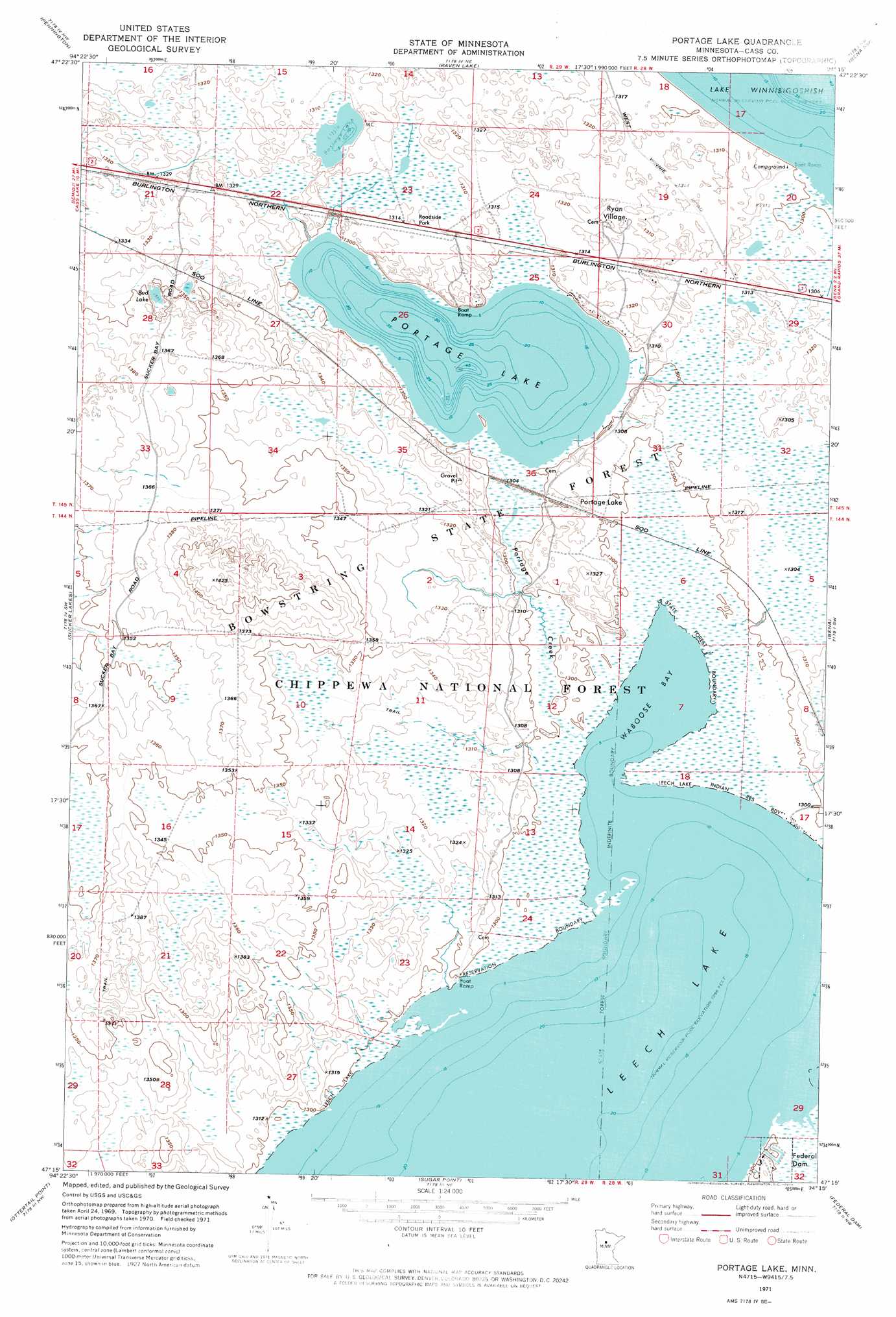
Portage Lake Topo Map Minnesota
To zoom in, hover over the map of Portage Lake
USGS Topo Quad 47094c3 - 1:24,000 scale
| Topo Map Name: | Portage Lake |
| USGS Topo Quad ID: | 47094c3 |
| Print Size: | ca. 21 1/4" wide x 27" high |
| Southeast Coordinates: | 47.25° N latitude / 94.25° W longitude |
| Map Center Coordinates: | 47.3125° N latitude / 94.3125° W longitude |
| U.S. State: | MN |
| Filename: | p47094c3.jpg |
| Download Map JPG Image: | Portage Lake topo map 1:24,000 scale |
| Map Type: | Orthophoto |
| Topo Series: | 7.5´ |
| Map Scale: | 1:24,000 |
| Source of Map Images: | United States Geological Survey (USGS) |
| Alternate Map Versions: |
Portage Lake MN 1971, updated 1974 Download PDF Buy paper map Portage Lake MN 1996, updated 1998 Download PDF Buy paper map Portage Lake MN 2011 Download PDF Buy paper map Portage Lake MN 2013 Download PDF Buy paper map Portage Lake MN 2016 Download PDF Buy paper map |
| FStopo: | US Forest Service topo Portage Lake is available: Download FStopo PDF Download FStopo TIF |
1:24,000 Topo Quads surrounding Portage Lake
Pimushe Lake |
Gimmer Lake |
Dixon Lake |
Pigeon Dam Lake |
Max |
Cass Lake |
Pennington |
Raven Lake |
Bena Nw |
Little Winnibigoshish Lake |
Pike Bay |
Sucker Lakes |
Portage Lake |
Bena |
Nushka Lake |
Steamboat Bay |
Ottertail Point |
Sugar Point |
Federal Dam |
Boy River |
Walker |
Jack Lake |
Whipholt |
Town Line Lake |
Tobique |
> Back to 47094a1 at 1:100,000 scale
> Back to 47094a1 at 1:250,000 scale
> Back to U.S. Topo Maps home
Portage Lake topo map: Gazetteer
Portage Lake: Bays
Waboose Bay elevation 395m 1295′Portage Lake: Flats
Portage Lake elevation 399m 1309′Portage Lake: Lakes
Bud Lake elevation 407m 1335′Little Portage Lake elevation 399m 1309′
Portage Lake elevation 396m 1299′
Portage Lake: Populated Places
Ryan Village elevation 402m 1318′Portage Lake: Streams
Portage Creek elevation 395m 1295′Portage Lake digital topo map on disk
Buy this Portage Lake topo map showing relief, roads, GPS coordinates and other geographical features, as a high-resolution digital map file on DVD: