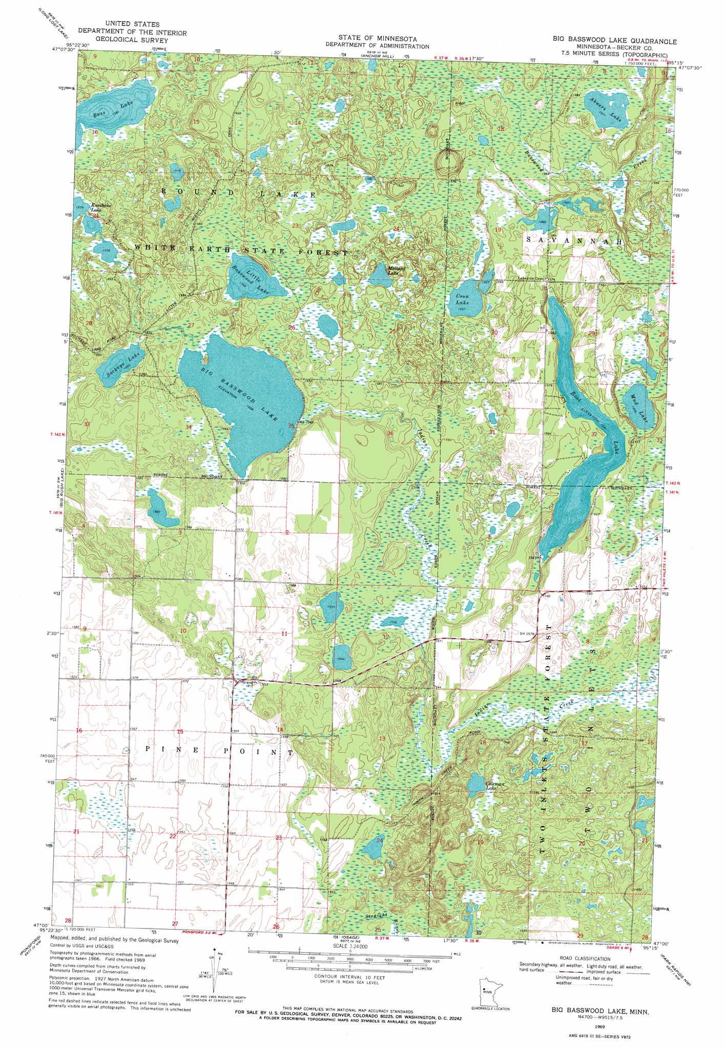
Big Basswood Lake Topo Map Minnesota
To zoom in, hover over the map of Big Basswood Lake
USGS Topo Quad 47095a3 - 1:24,000 scale
| Topo Map Name: | Big Basswood Lake |
| USGS Topo Quad ID: | 47095a3 |
| Print Size: | ca. 21 1/4" wide x 27" high |
| Southeast Coordinates: | 47° N latitude / 95.25° W longitude |
| Map Center Coordinates: | 47.0625° N latitude / 95.3125° W longitude |
| U.S. State: | MN |
| Filename: | o47095a3.jpg |
| Download Map JPG Image: | Big Basswood Lake topo map 1:24,000 scale |
| Map Type: | Topographic |
| Topo Series: | 7.5´ |
| Map Scale: | 1:24,000 |
| Source of Map Images: | United States Geological Survey (USGS) |
| Alternate Map Versions: |
Big Basswood Lake MN 1969, updated 1971 Download PDF Buy paper map Big Basswood Lake MN 2011 Download PDF Buy paper map Big Basswood Lake MN 2013 Download PDF Buy paper map Big Basswood Lake MN 2016 Download PDF Buy paper map |
1:24,000 Topo Quads surrounding Big Basswood Lake
Roy Lake |
Zerkel |
Heart Lake |
La Salle Lake |
Lake Hattie |
Tulaby Lake |
Long Lost Lake |
Anchor Hill |
Lake Itasca |
Schoolcraft Lake |
Many Point Lake |
Big Rush Lake |
Big Basswood Lake |
Two Inlets |
Skunk Lake |
Height Of Land Lake |
Ponsford |
Osage |
Park Rapids Nw |
Park Rapids |
Toad Mountain |
Evergreen |
Wolf Lake |
Park Rapids Sw |
Menahga |
> Back to 47095a1 at 1:100,000 scale
> Back to 47094a1 at 1:250,000 scale
> Back to U.S. Topo Maps home
Big Basswood Lake topo map: Gazetteer
Big Basswood Lake: Dams
Bass Lake Dam elevation 483m 1584′Big Basswood Lake: Lakes
Abners Lake elevation 479m 1571′Big Basswood Lake elevation 475m 1558′
Boot Lake elevation 470m 1541′
Coleman Lake elevation 471m 1545′
Coon Lake elevation 478m 1568′
Kneebone Lake elevation 481m 1578′
Little Basswood Lake elevation 478m 1568′
Mallard Lake elevation 481m 1578′
Mud Lake elevation 472m 1548′
Sockeye Lake elevation 476m 1561′
Big Basswood Lake: Trails
Little Scenic Trail elevation 486m 1594′Big Basswood Lake digital topo map on disk
Buy this Big Basswood Lake topo map showing relief, roads, GPS coordinates and other geographical features, as a high-resolution digital map file on DVD: