Lake Itasca Topo Map Minnesota
To zoom in, hover over the map of Lake Itasca
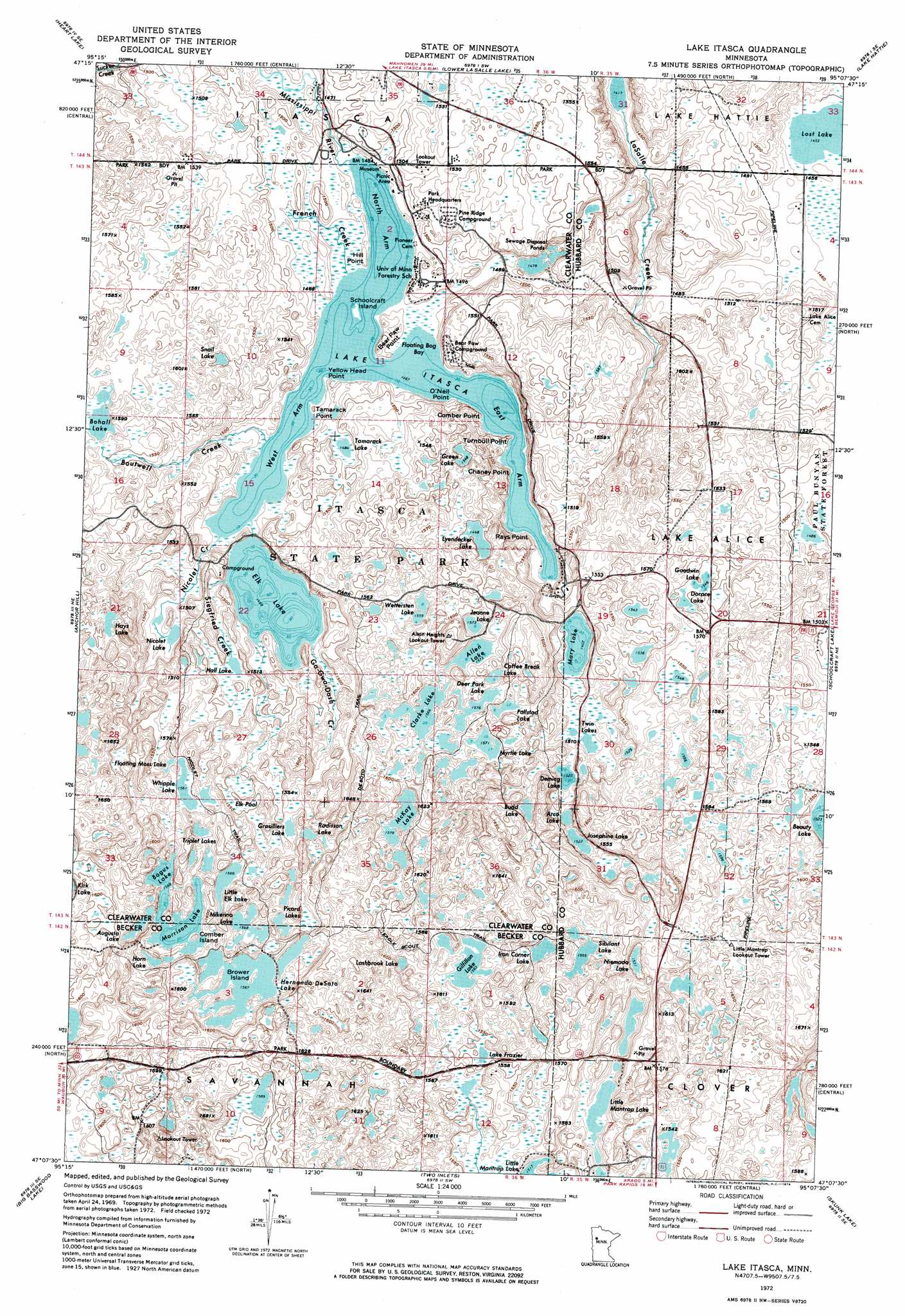
USGS Topo Quad 47095b2 - 1:24,000 scale
| Topo Map Name: | Lake Itasca |
| USGS Topo Quad ID: | 47095b2 |
| Print Size: | ca. 21 1/4" wide x 27" high |
| Southeast Coordinates: | 47.125° N latitude / 95.125° W longitude |
| Map Center Coordinates: | 47.1875° N latitude / 95.1875° W longitude |
| U.S. State: | MN |
| Filename: | p47095b2.jpg |
| Download Map JPG Image: | Lake Itasca topo map 1:24,000 scale |
| Map Type: | Orthophoto |
| Topo Series: | 7.5´ |
| Map Scale: | 1:24,000 |
| Source of Map Images: | United States Geological Survey (USGS) |
| Alternate Map Versions: |
Lake Itasca MN 1972, updated 1974 Download PDF Buy paper map Lake Itasca MN 2010 Download PDF Buy paper map Lake Itasca MN 2013 Download PDF Buy paper map Lake Itasca MN 2016 Download PDF Buy paper map |
1:24,000 Topo Quads surrounding Lake Itasca
Zerkel Nw |
Upper Rice Lake |
Alida |
Grant Lake |
Bemidji West |
Zerkel |
Heart Lake |
La Salle Lake |
Lake Hattie |
Frontenac Lake |
Long Lost Lake |
Anchor Hill |
Lake Itasca |
Schoolcraft Lake |
Lake George |
Big Rush Lake |
Big Basswood Lake |
Two Inlets |
Skunk Lake |
Mantrap Lake |
Ponsford |
Osage |
Park Rapids Nw |
Park Rapids |
Dorset |
> Back to 47095a1 at 1:100,000 scale
> Back to 47094a1 at 1:250,000 scale
> Back to U.S. Topo Maps home
Lake Itasca topo map: Gazetteer
Lake Itasca: Bays
Floating Bog Bay elevation 447m 1466′Lake Itasca: Capes
Bear Paw Point elevation 450m 1476′Chaney Point elevation 447m 1466′
Comber Point elevation 447m 1466′
Hill Point elevation 449m 1473′
O'Neil Point elevation 447m 1466′
Rays Point elevation 447m 1466′
Tamarack Point elevation 450m 1476′
Turnbull Point elevation 452m 1482′
Yellow Head Point elevation 448m 1469′
Lake Itasca: Islands
Brower Island elevation 480m 1574′Comber Island elevation 481m 1578′
Schoolcraft Island elevation 448m 1469′
Lake Itasca: Lakes
Allen Lake elevation 480m 1574′Arco Lake elevation 464m 1522′
Augusta Lake elevation 482m 1581′
Bogus Lake elevation 478m 1568′
Bohall Lake elevation 474m 1555′
Budd Lake elevation 476m 1561′
Clarke Lake elevation 478m 1568′
Coffee Break Lake elevation 480m 1574′
Deer Park Lake elevation 485m 1591′
Deming Lake elevation 466m 1528′
Dorace Lake elevation 472m 1548′
East Arm Lake Itasca elevation 447m 1466′
Elk Lake elevation 448m 1469′
Elk Pool elevation 474m 1555′
Fallstad Lake elevation 479m 1571′
Floating Moss Lake elevation 474m 1555′
Gilfillan Lake elevation 477m 1564′
Goodwin Lake elevation 472m 1548′
Green Lake elevation 472m 1548′
Grosilliers Lake elevation 477m 1564′
Hall Lake elevation 452m 1482′
Hays Lake elevation 479m 1571′
Hernando DeSoto Lake elevation 482m 1581′
Horn Lake elevation 482m 1581′
Iron Corner Lake elevation 470m 1541′
Jeanne Lake elevation 479m 1571′
Josephine Lake elevation 465m 1525′
Lake Frazier elevation 473m 1551′
Lake Itasca elevation 447m 1466′
Lashbrook Lake elevation 476m 1561′
Little Elk Lake elevation 478m 1568′
Lost Lake elevation 443m 1453′
Lyendecker Lake elevation 470m 1541′
Mary Lake elevation 457m 1499′
McKay Lake elevation 482m 1581′
Mikenna Lake elevation 478m 1568′
Morrison Lake elevation 478m 1568′
Myrtle Lake elevation 477m 1564′
Nicolet Lake elevation 449m 1473′
Niemada Lake elevation 470m 1541′
North Arm Lake Itasca elevation 447m 1466′
Picard Lakes elevation 482m 1581′
Radisson Lake elevation 477m 1564′
Sibilant Lake elevation 474m 1555′
Snail Lake elevation 470m 1541′
Tamarack Lake elevation 452m 1482′
Triplet Lakes elevation 482m 1581′
Twin Lakes elevation 458m 1502′
West Arm Lake Itasca elevation 447m 1466′
Wettersten Lake elevation 472m 1548′
Whipple Lake elevation 476m 1561′
Lake Itasca: Parks
Geology of Minnesota Geological Marker elevation 453m 1486′Itasca State Park elevation 475m 1558′
Old Northwest Territory Historical Marker elevation 458m 1502′
Reverend Joseph A Gilfillan Historical Marker elevation 458m 1502′
Search for the Mississippi's Source Historical Marker elevation 458m 1502′
Theodore and Johanna Wegmann Historical Marker elevation 457m 1499′
Lake Itasca: Post Offices
Douglas Lodge Post Office (historical) elevation 470m 1541′Lake Itasca: Streams
Boutwell Creek elevation 448m 1469′French Creek elevation 448m 1469′
Ga-Gwa-Dosh Creek elevation 449m 1473′
Nicolet Creek elevation 448m 1469′
Siegfried Creek elevation 448m 1469′
Lake Itasca: Trails
Desoto Trail elevation 486m 1594′Eagle Scout Trail elevation 483m 1584′
Nicolet Trail elevation 479m 1571′
Lake Itasca digital topo map on disk
Buy this Lake Itasca topo map showing relief, roads, GPS coordinates and other geographical features, as a high-resolution digital map file on DVD: