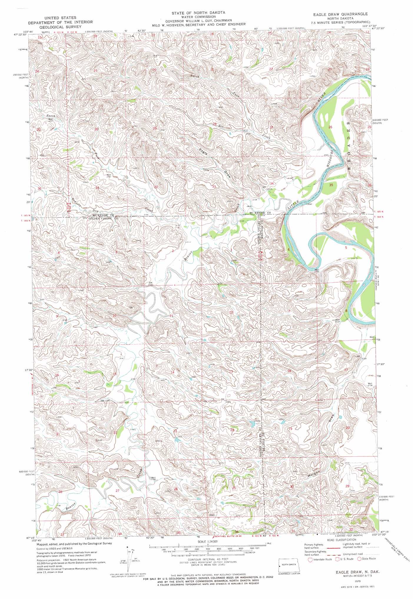
Eagle Draw Topo Map North Dakota
To zoom in, hover over the map of Eagle Draw
USGS Topo Quad 47103c6 - 1:24,000 scale
| Topo Map Name: | Eagle Draw |
| USGS Topo Quad ID: | 47103c6 |
| Print Size: | ca. 21 1/4" wide x 27" high |
| Southeast Coordinates: | 47.25° N latitude / 103.625° W longitude |
| Map Center Coordinates: | 47.3125° N latitude / 103.6875° W longitude |
| U.S. State: | ND |
| Filename: | O47103C6.jpg |
| Download Map JPG Image: | Eagle Draw topo map 1:24,000 scale |
| Map Type: | Topographic |
| Topo Series: | 7.5´ |
| Map Scale: | 1:24,000 |
| Source of Map Images: | United States Geological Survey (USGS) |
| Alternate Map Versions: |
Eagle Draw ND 1970, updated 1972 Download PDF Buy paper map Eagle Draw ND 1997, updated 2001 Download PDF Buy paper map Eagle Draw ND 2011 Download PDF Buy paper map Eagle Draw ND 2014 Download PDF Buy paper map |
| FStopo: | US Forest Service topo Eagle Draw is available: Download FStopo PDF Download FStopo TIF |
1:24,000 Topo Quads surrounding Eagle Draw
Phillip Spring |
Sheep Creek |
Burning Mine Butte |
Red Wing Creek |
Sperati Point |
Squaw Gap |
Flat Rock Butte |
Cinnamon Creek |
Ice Box Canyon |
Wolf Coulee |
Trotters |
Trotters Se |
Eagle Draw |
Hanks Gully |
Squaretop Butte |
Hootowl Creek West |
Hootowl Creek East |
Roosevelt Creek West |
Roosevelt Creek East |
Gorham Nw |
Hootowl Creek Sw |
West Twin Butte |
Wannagan Creek West |
Wannagan Creek East |
Gorham Sw |
> Back to 47103a1 at 1:100,000 scale
> Back to 47102a1 at 1:250,000 scale
> Back to U.S. Topo Maps home
Eagle Draw topo map: Gazetteer
Eagle Draw: Streams
Beaver Creek elevation 634m 2080′Beaver Creek elevation 634m 2080′
Buckhorn Creek elevation 641m 2103′
Fantail Creek elevation 645m 2116′
North Fork Prairie Dog Creek elevation 646m 2119′
North Fork Six Creek elevation 651m 2135′
Porcupine Creek elevation 648m 2125′
Prairie Dog Creek elevation 641m 2103′
Six Creek elevation 634m 2080′
Eagle Draw: Valleys
Dietz Draw elevation 665m 2181′Eagle Draw elevation 641m 2103′
Morgan Draw elevation 640m 2099′
Eagle Draw digital topo map on disk
Buy this Eagle Draw topo map showing relief, roads, GPS coordinates and other geographical features, as a high-resolution digital map file on DVD:
Eastern Montana & Western North Dakota
Buy digital topo maps: Eastern Montana & Western North Dakota