Petes Creek Topo Map North Dakota
To zoom in, hover over the map of Petes Creek
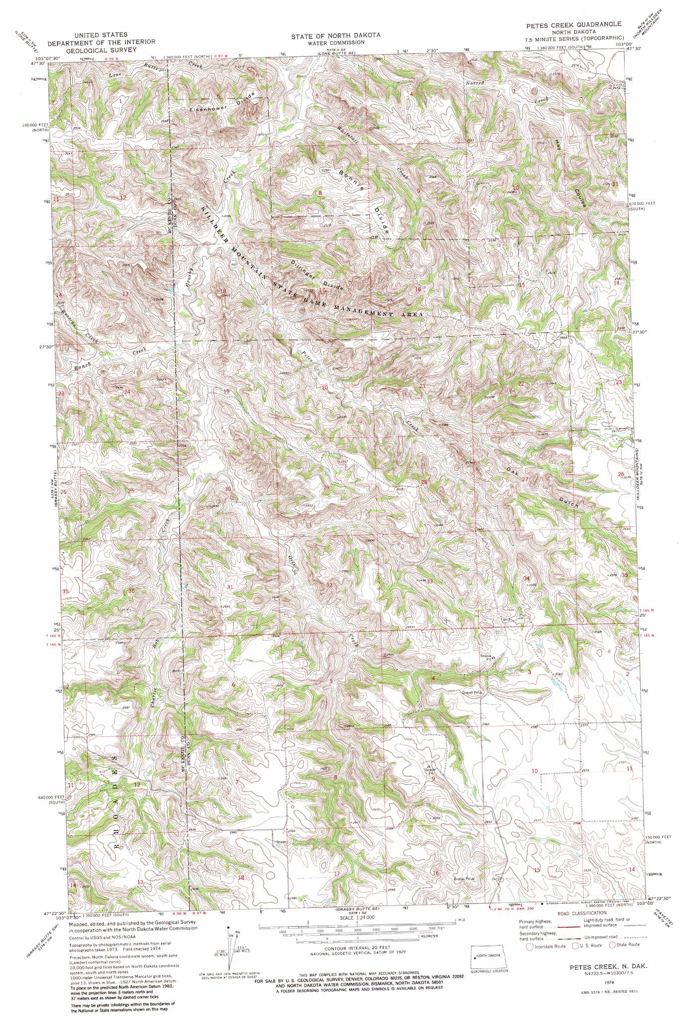
USGS Topo Quad 47103d1 - 1:24,000 scale
| Topo Map Name: | Petes Creek |
| USGS Topo Quad ID: | 47103d1 |
| Print Size: | ca. 21 1/4" wide x 27" high |
| Southeast Coordinates: | 47.375° N latitude / 103° W longitude |
| Map Center Coordinates: | 47.4375° N latitude / 103.0625° W longitude |
| U.S. State: | ND |
| Filename: | O47103D1.jpg |
| Download Map JPG Image: | Petes Creek topo map 1:24,000 scale |
| Map Type: | Topographic |
| Topo Series: | 7.5´ |
| Map Scale: | 1:24,000 |
| Source of Map Images: | United States Geological Survey (USGS) |
| Alternate Map Versions: |
Petes Creek ND 1974, updated 1977 Download PDF Buy paper map Petes Creek ND 1974, updated 1984 Download PDF Buy paper map Petes Creek ND 1997, updated 2001 Download PDF Buy paper map Petes Creek ND 2011 Download PDF Buy paper map Petes Creek ND 2014 Download PDF Buy paper map |
| FStopo: | US Forest Service topo Petes Creek is available: Download FStopo PDF Download FStopo TIF |
1:24,000 Topo Quads surrounding Petes Creek
Tepee Buttes |
Lone Butte Nw |
Lone Butte Ne |
Croff |
Figure 4 Ranch |
Long X Divide |
Lone Butte |
Lone Butte Se |
North Killdeer Mountain |
Lost Bridge |
Buckskin Butte |
Grassy Butte |
Petes Creek |
Killdeer Mountains |
Oakdale |
Scairt Woman Draw |
Grassy Butte Sw |
Grassy Butte Se |
Fayette |
Killdeer |
Gorham |
Fairfield |
Hungry Man Butte |
Manning Nw |
Manning |
> Back to 47103a1 at 1:100,000 scale
> Back to 47102a1 at 1:250,000 scale
> Back to U.S. Topo Maps home
Petes Creek topo map: Gazetteer
Petes Creek: Oilfields
Little Knife Oil Field elevation 783m 2568′Petes Creek: Parks
Killdeer Mountain State Game Management Area elevation 804m 2637′Petes Creek: Ridges
Bonnie Divide elevation 758m 2486′Dillinger Divide elevation 746m 2447′
Eisenhower Divide elevation 753m 2470′
Petes Creek: Streams
Charlie Bob Creek elevation 658m 2158′Deer Creek elevation 658m 2158′
Lone Butte Creek elevation 621m 2037′
Petes Creek elevation 636m 2086′
Ranch Creek elevation 653m 2142′
Russian Creek elevation 654m 2145′
Whitetail Creek elevation 624m 2047′
Petes Creek: Valleys
Hay Coulee elevation 672m 2204′Oak Gulch elevation 679m 2227′
Petes Creek digital topo map on disk
Buy this Petes Creek topo map showing relief, roads, GPS coordinates and other geographical features, as a high-resolution digital map file on DVD:
Eastern Montana & Western North Dakota
Buy digital topo maps: Eastern Montana & Western North Dakota