Glendive Topo Map Montana
To zoom in, hover over the map of Glendive
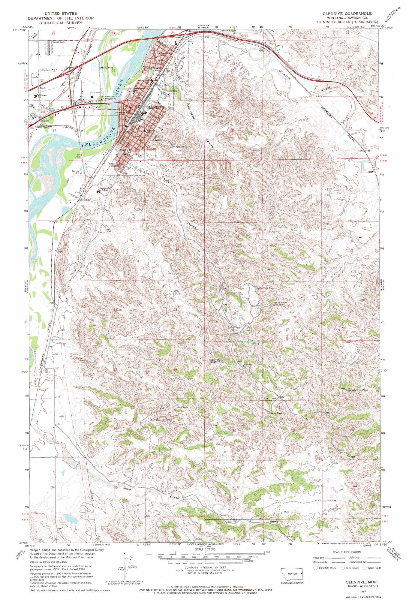
USGS Topo Quad 47104a6 - 1:24,000 scale
| Topo Map Name: | Glendive |
| USGS Topo Quad ID: | 47104a6 |
| Print Size: | ca. 21 1/4" wide x 27" high |
| Southeast Coordinates: | 47° N latitude / 104.625° W longitude |
| Map Center Coordinates: | 47.0625° N latitude / 104.6875° W longitude |
| U.S. State: | MT |
| Filename: | o47104a6.jpg |
| Download Map JPG Image: | Glendive topo map 1:24,000 scale |
| Map Type: | Topographic |
| Topo Series: | 7.5´ |
| Map Scale: | 1:24,000 |
| Source of Map Images: | United States Geological Survey (USGS) |
| Alternate Map Versions: |
Glendive MT 1967, updated 1970 Download PDF Buy paper map Glendive MT 1967, updated 1970 Download PDF Buy paper map Glendive MT 2011 Download PDF Buy paper map Glendive MT 2014 Download PDF Buy paper map |
1:24,000 Topo Quads surrounding Glendive
Stinking Coulee |
Morgan Creek School |
Kolberg Ranch |
Intake |
Savage Sw |
Poverty Flat West |
Poverty Flat East |
Stipek |
Belle Prairie |
Cluster Buttes Nw |
Pleasant View |
Forest Park |
Glendive |
Allard |
Cluster Buttes Sw |
Marsh |
Hoyt |
Upper Magpie Reservoir |
Twin Forks Reservoir |
Hodges |
Marsh Sw |
Simons Butte |
Graveyard Hill Sw |
Graveyard Hill |
Hodges Sw |
> Back to 47104a1 at 1:100,000 scale
> Back to 47104a1 at 1:250,000 scale
> Back to U.S. Topo Maps home
Glendive topo map: Gazetteer
Glendive: Bridges
Bell Street Bridge (historical) elevation 623m 2043′Glendive: Cliffs
Iron Bluffs elevation 705m 2312′Glendive: Crossings
Interchange 213 elevation 641m 2103′Interchange 215 elevation 646m 2119′
Glendive: Dams
Glendive Sewage Lagoon Dam elevation 624m 2047′Glendive West Sewage Lagoon Dam elevation 625m 2050′
Myron Number 2 Dam elevation 665m 2181′
Glendive: Parks
ABC Little League Field elevation 625m 2050′Babe Ruth Field elevation 627m 2057′
Community Park elevation 630m 2066′
Eyer Park elevation 625m 2050′
Glendive Historical Marker elevation 624m 2047′
Historical Landmark Park elevation 624m 2047′
Jaycee West Park elevation 621m 2037′
Lloyd Square Park elevation 632m 2073′
Makoshika State Park elevation 792m 2598′
Perham Field elevation 627m 2057′
Whipkey Park elevation 625m 2050′
Glendive: Populated Places
Casitas Del Rio East Mobile Home Park elevation 623m 2043′Curry elevation 643m 2109′
Glendive elevation 629m 2063′
Highland Mobile Home Park elevation 649m 2129′
I-94 Trailer Park elevation 623m 2043′
La Bree Mobile Homes Incorporated elevation 623m 2043′
Spring Grove Trailer Court elevation 624m 2047′
West Glendive elevation 646m 2119′
Glendive: Post Offices
Glendive Post Office elevation 629m 2063′Glendive: Streams
Dry Creek elevation 623m 2043′Forbill Creek elevation 630m 2066′
Glendive: Trails
Cap Rock Nature Trail elevation 806m 2644′Glendive: Valleys
Cains Coulee elevation 628m 2060′Graveyard Coulee elevation 633m 2076′
Glendive: Wells
15N55E12ABDC01 Well elevation 650m 2132′15N55E20BAA_01 Well elevation 631m 2070′
15N55E22CACA01 Well elevation 646m 2119′
15N55E23AAD_01 Well elevation 690m 2263′
15N55E25ABCB01 Well elevation 752m 2467′
15N55E26CCC_03 Well elevation 621m 2037′
15N55E31CAA_02 Well elevation 752m 2467′
15N56E04AACB01 Well elevation 641m 2103′
15N56E18ACAC01 Well elevation 788m 2585′
16N55E22CDD_01 Well elevation 646m 2119′
16N55E23AAB_01 Well elevation 707m 2319′
16N55E23BDD_01 Well elevation 624m 2047′
16N55E23CC__01 Well elevation 635m 2083′
16N55E24BCB_01 Well elevation 626m 2053′
16N55E26BC__01 Well elevation 624m 2047′
16N55E26CBA_01 Well elevation 621m 2037′
16N55E26CCC_02 Well elevation 675m 2214′
16N55E26CCC_04 Well elevation 622m 2040′
16N55E26CCD_01 Well elevation 651m 2135′
16N55E27AC__01 Well elevation 648m 2125′
16N55E27BAD_01 Well elevation 645m 2116′
16N55E27CAD_01 Well elevation 624m 2047′
16N55E27DAD_01 Well elevation 622m 2040′
16N55E27DB__01 Well elevation 632m 2073′
16N55E27DCD_01 Well elevation 622m 2040′
16N55E27DDC_01 Well elevation 624m 2047′
16N55E33ADD_01 Well elevation 653m 2142′
16N55E34AA__01 Well elevation 624m 2047′
16N55E34AAA_01 Well elevation 624m 2047′
16N55E34ABA_01 Well elevation 624m 2047′
16N55E34ABB_01 Well elevation 640m 2099′
16N55E34DA__01 Well elevation 621m 2037′
16N55E35AB__01 Well elevation 628m 2060′
16N55E35AB__02 Well elevation 628m 2060′
Glendive digital topo map on disk
Buy this Glendive topo map showing relief, roads, GPS coordinates and other geographical features, as a high-resolution digital map file on DVD:
Eastern Montana & Western North Dakota
Buy digital topo maps: Eastern Montana & Western North Dakota