Belle Prairie Topo Map Montana
To zoom in, hover over the map of Belle Prairie
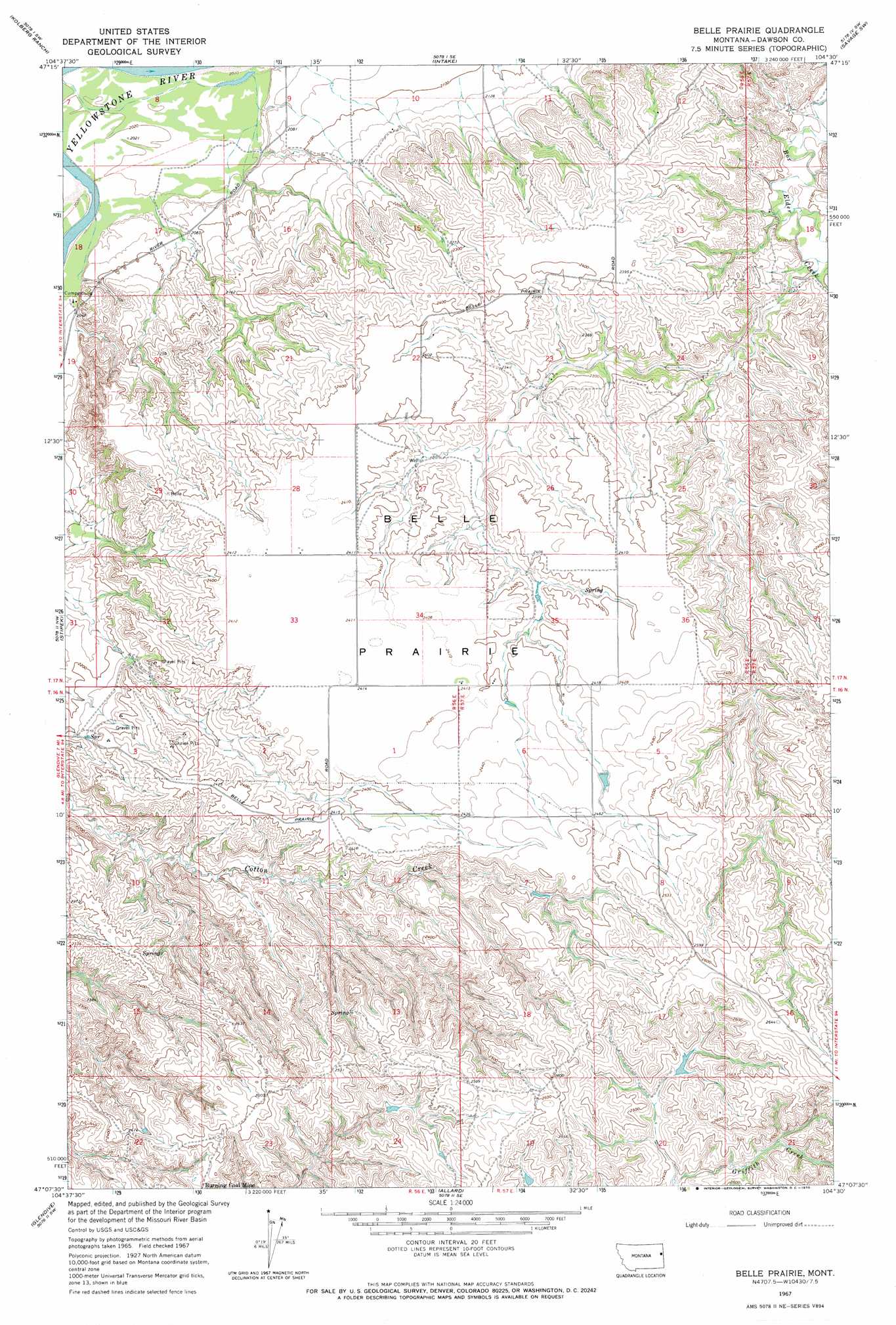
USGS Topo Quad 47104b5 - 1:24,000 scale
| Topo Map Name: | Belle Prairie |
| USGS Topo Quad ID: | 47104b5 |
| Print Size: | ca. 21 1/4" wide x 27" high |
| Southeast Coordinates: | 47.125° N latitude / 104.5° W longitude |
| Map Center Coordinates: | 47.1875° N latitude / 104.5625° W longitude |
| U.S. State: | MT |
| Filename: | o47104b5.jpg |
| Download Map JPG Image: | Belle Prairie topo map 1:24,000 scale |
| Map Type: | Topographic |
| Topo Series: | 7.5´ |
| Map Scale: | 1:24,000 |
| Source of Map Images: | United States Geological Survey (USGS) |
| Alternate Map Versions: |
Belle Prairie MT 1967, updated 1970 Download PDF Buy paper map Belle Prairie MT 2011 Download PDF Buy paper map Belle Prairie MT 2014 Download PDF Buy paper map |
1:24,000 Topo Quads surrounding Belle Prairie
Red Top |
Intake Nw |
Allard Ranch |
Knife River Mine |
Savage |
Morgan Creek School |
Kolberg Ranch |
Intake |
Savage Sw |
Savage Se |
Poverty Flat East |
Stipek |
Belle Prairie |
Cluster Buttes Nw |
Cluster Buttes |
Forest Park |
Glendive |
Allard |
Cluster Buttes Sw |
Cluster Buttes Se |
Hoyt |
Upper Magpie Reservoir |
Twin Forks Reservoir |
Hodges |
Freeman Creek |
> Back to 47104a1 at 1:100,000 scale
> Back to 47104a1 at 1:250,000 scale
> Back to U.S. Topo Maps home
Belle Prairie topo map: Gazetteer
Belle Prairie: Dams
Arthur Number 1 Dam elevation 746m 2447′Belle Prairie: Flats
Belle Prairie elevation 738m 2421′Belle Prairie: Streams
Serrine Creek elevation 628m 2060′Shryve Creek elevation 669m 2194′
Belle Prairie: Valleys
Coal Coulee elevation 632m 2073′Wards Coulee elevation 610m 2001′
Belle Prairie: Wells
16N56E02BDCB01 Well elevation 713m 2339′16N56E06AABC01 Well elevation 736m 2414′
16N57E05CADA01 Well elevation 755m 2477′
17N56E17BADD01 Well elevation 614m 2014′
17N56E23DBCB01 Well elevation 690m 2263′
17N56E27BDAA01 Well elevation 718m 2355′
Belle Prairie digital topo map on disk
Buy this Belle Prairie topo map showing relief, roads, GPS coordinates and other geographical features, as a high-resolution digital map file on DVD:
Eastern Montana & Western North Dakota
Buy digital topo maps: Eastern Montana & Western North Dakota