Savage Sw Topo Map Montana
To zoom in, hover over the map of Savage Sw
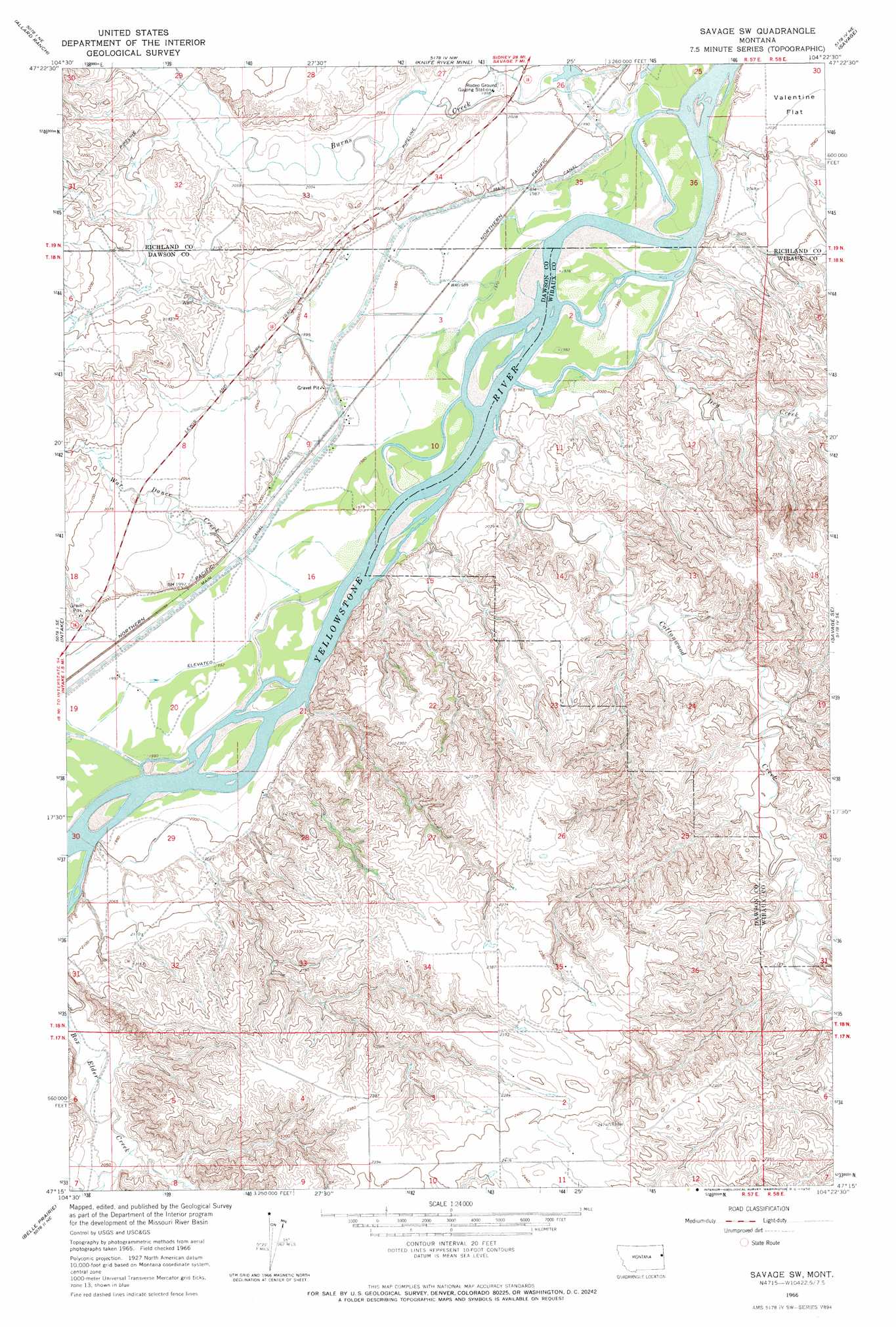
USGS Topo Quad 47104c4 - 1:24,000 scale
| Topo Map Name: | Savage Sw |
| USGS Topo Quad ID: | 47104c4 |
| Print Size: | ca. 21 1/4" wide x 27" high |
| Southeast Coordinates: | 47.25° N latitude / 104.375° W longitude |
| Map Center Coordinates: | 47.3125° N latitude / 104.4375° W longitude |
| U.S. State: | MT |
| Filename: | o47104c4.jpg |
| Download Map JPG Image: | Savage Sw topo map 1:24,000 scale |
| Map Type: | Topographic |
| Topo Series: | 7.5´ |
| Map Scale: | 1:24,000 |
| Source of Map Images: | United States Geological Survey (USGS) |
| Alternate Map Versions: |
Savage SW MT 1966, updated 1970 Download PDF Buy paper map Savage SW MT 2011 Download PDF Buy paper map Savage SW MT 2014 Download PDF Buy paper map |
1:24,000 Topo Quads surrounding Savage Sw
Butler Table |
Mccone Heights |
Larson School |
Crane |
Piche |
Intake Nw |
Allard Ranch |
Knife River Mine |
Savage |
Skaar Nw |
Kolberg Ranch |
Intake |
Savage Sw |
Savage Se |
Parson Creek |
Stipek |
Belle Prairie |
Cluster Buttes Nw |
Cluster Buttes |
Odland Dam Nw |
Glendive |
Allard |
Cluster Buttes Sw |
Cluster Buttes Se |
Odland Dam Sw |
> Back to 47104a1 at 1:100,000 scale
> Back to 47104a1 at 1:250,000 scale
> Back to U.S. Topo Maps home
Savage Sw topo map: Gazetteer
Savage Sw: Islands
Chrome Island elevation 605m 1984′Idiom Island elevation 601m 1971′
Snake Island elevation 605m 1984′
Savage Sw: Lakes
Burns Lake elevation 606m 1988′Savage Sw: Populated Places
Lufboro (historical) elevation 717m 2352′Savage Sw: Post Offices
Marco Post Office (historical) elevation 608m 1994′Savage Sw: Streams
Burns Creek elevation 599m 1965′Cottonwood Creek elevation 602m 1975′
Dry Creek elevation 601m 1971′
War Dance Creek elevation 608m 1994′
Savage Sw: Valleys
Black Tail Coulee elevation 608m 1994′Savage Sw: Wells
17N57E02DC__01 Well elevation 743m 2437′18N57E03AB__01 Well elevation 608m 1994′
18N57E03ABAB01 Well elevation 605m 1984′
18N57E04AA__01 Well elevation 609m 1998′
18N57E04CD__01 Well elevation 626m 2053′
18N57E04DD__01 Well elevation 609m 1998′
18N57E06ADDA01 Well elevation 668m 2191′
18N57E09DBAB01 Well elevation 605m 1984′
18N57E10BB__01 Well elevation 608m 1994′
18N57E11DACB01 Well elevation 604m 1981′
18N57E15ADCC01 Well elevation 636m 2086′
18N57E17BD__01 Well elevation 631m 2070′
18N57E19AD__01 Well elevation 610m 2001′
18N57E20BC__01 Well elevation 607m 1991′
18N57E24DDAA01 Well elevation 635m 2083′
18N57E29DDBD01 Well elevation 634m 2080′
19N57E26DD__01 Well elevation 602m 1975′
19N57E27DDAC01 Well elevation 613m 2011′
19N57E34CC__01 Well elevation 609m 1998′
Savage Sw digital topo map on disk
Buy this Savage Sw topo map showing relief, roads, GPS coordinates and other geographical features, as a high-resolution digital map file on DVD:
Eastern Montana & Western North Dakota
Buy digital topo maps: Eastern Montana & Western North Dakota