Piche Topo Map Montana
To zoom in, hover over the map of Piche
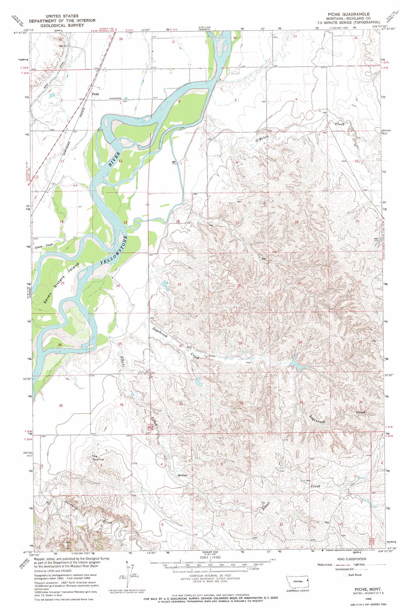
USGS Topo Quad 47104e2 - 1:24,000 scale
| Topo Map Name: | Piche |
| USGS Topo Quad ID: | 47104e2 |
| Print Size: | ca. 21 1/4" wide x 27" high |
| Southeast Coordinates: | 47.5° N latitude / 104.125° W longitude |
| Map Center Coordinates: | 47.5625° N latitude / 104.1875° W longitude |
| U.S. State: | MT |
| Filename: | o47104e2.jpg |
| Download Map JPG Image: | Piche topo map 1:24,000 scale |
| Map Type: | Topographic |
| Topo Series: | 7.5´ |
| Map Scale: | 1:24,000 |
| Source of Map Images: | United States Geological Survey (USGS) |
| Alternate Map Versions: |
Piche MT 1966, updated 1970 Download PDF Buy paper map Piche MT 2011 Download PDF Buy paper map Piche MT 2014 Download PDF Buy paper map |
1:24,000 Topo Quads surrounding Piche
Girard |
Brorson |
Fairview Sw |
Fairview |
Cartwright |
Crane Nw |
Crane Ne |
Sidney |
Sidney Ne |
Horse Creek School |
Larson School |
Crane |
Piche |
Sidney Se |
Phillip Spring |
Knife River Mine |
Savage |
Skaar Nw |
Skaar Ne |
Squaw Gap |
Savage Sw |
Savage Se |
Parson Creek |
Skaar |
Trotters |
> Back to 47104e1 at 1:100,000 scale
> Back to 47104a1 at 1:250,000 scale
> Back to U.S. Topo Maps home
Piche topo map: Gazetteer
Piche: Canals
Main Canal elevation 602m 1975′Piche: Dams
Hastetter Number 1 Dam elevation 626m 2053′Hastetter Number 2 Dam elevation 612m 2007′
Piche: Islands
Buella Island elevation 583m 1912′Diamond Island elevation 582m 1909′
Seven Sisters Island elevation 580m 1902′
Piche: Populated Places
Piche elevation 586m 1922′Piche: Streams
Alkali Creek elevation 578m 1896′Coal Bank Slough elevation 580m 1902′
Crane Creek elevation 580m 1902′
O'Brien Creek elevation 580m 1902′
O'Brien Creek elevation 577m 1893′
Sagebrush Creek elevation 593m 1945′
Piche: Summits
The Pyramid elevation 645m 2116′Piche: Wells
20N59E03DBA_01 Well elevation 665m 2181′20N59E04DDDB01 Well elevation 639m 2096′
20N59E08BC__01 Well elevation 605m 1984′
20N59E11BDC_01 Well elevation 657m 2155′
21N58E01AA__01 Well elevation 584m 1916′
21N58E02AD__01 Well elevation 586m 1922′
21N58E02DD__01 Well elevation 585m 1919′
21N58E11BB__01 Well elevation 600m 1968′
21N58E11BD__01 Well elevation 600m 1968′
21N58E11DC__01 Well elevation 586m 1922′
21N58E14BB__01 Well elevation 595m 1952′
21N58E14DB__01 Well elevation 584m 1916′
21N59E03CC__01 Well elevation 602m 1975′
21N59E08AA__01 Well elevation 610m 2001′
21N59E08BB__01 Well elevation 584m 1916′
21N59E08BCD_01 Well elevation 602m 1975′
21N59E08DB__01 Well elevation 611m 2004′
21N59E15DDBA01 Well elevation 638m 2093′
21N59E18CD__01 Well elevation 604m 1981′
21N59E20AAAC01 Well elevation 612m 2007′
21N59E22DDC_01 Well elevation 666m 2185′
21N59E30BBCA01 Well elevation 607m 1991′
21N59E33DBBB01 Well elevation 649m 2129′
22N58E36DD__01 Well elevation 587m 1925′
22N58E36DDD_01 Well elevation 584m 1916′
22N59E31CB__01 Well elevation 580m 1902′
22N59E31CC__01 Well elevation 581m 1906′
22N59E31DD__01 Well elevation 582m 1909′
22N59E32CD__01 Well elevation 579m 1899′
22N59E32DA__01 Well elevation 587m 1925′
22N59E32DD__01 Well elevation 585m 1919′
22N59E34CA__01 Well elevation 620m 2034′
22N59E34CB__01 Well elevation 610m 2001′
Piche digital topo map on disk
Buy this Piche topo map showing relief, roads, GPS coordinates and other geographical features, as a high-resolution digital map file on DVD:
Eastern Montana & Western North Dakota
Buy digital topo maps: Eastern Montana & Western North Dakota