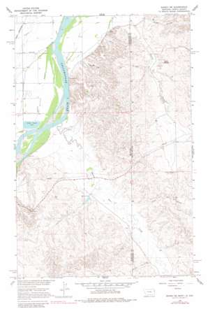
Sidney Ne Topo Map Montana
To zoom in, hover over the map of Sidney Ne
USGS Topo Quad 47104f1 - 1:24,000 scale
| Topo Map Name: | Sidney Ne |
| USGS Topo Quad ID: | 47104f1 |
| Print Size: | ca. 21 1/4" wide x 27" high |
| Southeast Coordinates: | 47.625° N latitude / 104° W longitude |
| Map Center Coordinates: | 47.6875° N latitude / 104.0625° W longitude |
| U.S. States: | MT, ND |
| Filename: | o47104f1.jpg |
| Download Map JPG Image: | Sidney Ne topo map 1:24,000 scale |
| Map Type: | Topographic |
| Topo Series: | 7.5´ |
| Map Scale: | 1:24,000 |
| Source of Map Images: | United States Geological Survey (USGS) |
| Alternate Map Versions: |
Sidney NE MT 1966, updated 1970 Download PDF Buy paper map Sidney NE MT 1966, updated 1980 Download PDF Buy paper map Sidney NE MT 1997, updated 2001 Download PDF Buy paper map Sidney NE MT 2011 Download PDF Buy paper map Sidney NE MT 2014 Download PDF Buy paper map |
| FStopo: | US Forest Service topo Sidney NE is available: Download FStopo PDF Download FStopo TIF |
1:24,000 Topo Quads surrounding Sidney Ne
> Back to 47104e1 at 1:100,000 scale
> Back to 47104a1 at 1:250,000 scale
> Back to U.S. Topo Maps home
Sidney Ne topo map: Gazetteer
Sidney Ne: Dams
Christensen Dam elevation 582m 1909′Lower Holly Sugar Dam elevation 580m 1902′
McGlynn Dam elevation 596m 1955′
McGlynn Reservoir Dam elevation 599m 1965′
Sturgis Dam elevation 597m 1958′
Sidney Ne: Mines
Thiel Mine elevation 629m 2063′Sidney Ne: Reservoirs
McGlynn Reservoir elevation 599m 1965′Sidney Ne: Springs
Estes Spring elevation 600m 1968′Sidney Ne: Streams
Alkali Creek elevation 593m 1945′Bennie Peer Creek elevation 573m 1879′
Bennie Peer Creek elevation 573m 1879′
Devitt Creek elevation 598m 1961′
Devitt Creek elevation 598m 1961′
Sidney Ne: Valleys
Estes Coulee elevation 593m 1945′Sidney Ne: Wells
22N59E02DA__01 Well elevation 578m 1896′22N59E03AA__01 Well elevation 580m 1902′
22N59E03AA__02 Well elevation 580m 1902′
22N59E11CD__01 Well elevation 625m 2050′
22N59E11DDCB01 Well elevation 620m 2034′
22N59E13CCBB01 Well elevation 634m 2080′
22N59E14BABD01 Well elevation 627m 2057′
22N59E14CB__01 Well elevation 642m 2106′
22N59E24CBBD01 Well elevation 628m 2060′
22N60E07CC__01 Well elevation 589m 1932′
22N60E07CCDB01 Well elevation 587m 1925′
23N52E28AA__01 Well elevation 639m 2096′
23N59E13CC__01 Well elevation 584m 1916′
23N59E13CCCC01 Well elevation 584m 1916′
23N59E14CC__01 Well elevation 586m 1922′
23N59E22DD__01 Well elevation 586m 1922′
23N59E23AD__01 Well elevation 584m 1916′
23N59E23BA__01 Well elevation 586m 1922′
23N59E23DC__01 Well elevation 583m 1912′
23N59E24AA__01 Well elevation 578m 1896′
23N59E24BB__01 Well elevation 584m 1916′
23N59E24DB__01 Well elevation 578m 1896′
23N59E24DC__01 Well elevation 578m 1896′
23N59E25AA__01 Well elevation 580m 1902′
23N59E26AB__01 Well elevation 580m 1902′
23N59E26BA__01 Well elevation 586m 1922′
23N59E26CC__01 Well elevation 580m 1902′
23N59E26DD__01 Well elevation 577m 1893′
23N59E27AA__01 Well elevation 586m 1922′
23N59E35BC__01 Well elevation 580m 1902′
23N59E35DC__01 Well elevation 579m 1899′
23N59E35DC__02 Well elevation 579m 1899′
23N60E18DD__01 Well elevation 578m 1896′
23N60E19AA__01 Well elevation 579m 1899′
23N60E19BC__01 Well elevation 578m 1896′
23N60E19CA__01 Well elevation 579m 1899′
23N60E19CA__02 Well elevation 579m 1899′
Sidney Ne digital topo map on disk
Buy this Sidney Ne topo map showing relief, roads, GPS coordinates and other geographical features, as a high-resolution digital map file on DVD:
Eastern Montana & Western North Dakota
Buy digital topo maps: Eastern Montana & Western North Dakota


