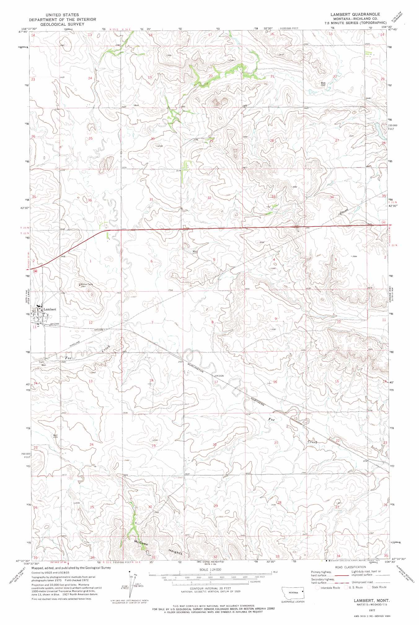
Lambert Topo Map Montana
To zoom in, hover over the map of Lambert
USGS Topo Quad 47104f5 - 1:24,000 scale
| Topo Map Name: | Lambert |
| USGS Topo Quad ID: | 47104f5 |
| Print Size: | ca. 21 1/4" wide x 27" high |
| Southeast Coordinates: | 47.625° N latitude / 104.5° W longitude |
| Map Center Coordinates: | 47.6875° N latitude / 104.5625° W longitude |
| U.S. State: | MT |
| Filename: | o47104f5.jpg |
| Download Map JPG Image: | Lambert topo map 1:24,000 scale |
| Map Type: | Topographic |
| Topo Series: | 7.5´ |
| Map Scale: | 1:24,000 |
| Source of Map Images: | United States Geological Survey (USGS) |
| Alternate Map Versions: |
Lambert MT 1972, updated 1975 Download PDF Buy paper map Lambert MT 2011 Download PDF Buy paper map Lambert MT 2014 Download PDF Buy paper map |
1:24,000 Topo Quads surrounding Lambert
Elmdale |
Elm Coulee |
Andes |
Blue Hill |
Sioux Pass |
Carda Coulee |
Three Buttes Creek West |
Three Buttes Creek East |
Girard |
Brorson |
Enid |
Fox Lake |
Lambert |
Crane Nw |
Crane Ne |
Enid Se |
Butler Table |
Mccone Heights |
Larson School |
Crane |
Red Top |
Intake Nw |
Allard Ranch |
Knife River Mine |
Savage |
> Back to 47104e1 at 1:100,000 scale
> Back to 47104a1 at 1:250,000 scale
> Back to U.S. Topo Maps home
Lambert topo map: Gazetteer
Lambert: Dams
A M Prevost Dam elevation 754m 2473′Prevost Number 2 Dam elevation 755m 2477′
Lambert: Parks
Lambert Park elevation 725m 2378′Lambert: Populated Places
Fox Lake elevation 729m 2391′Lambert elevation 723m 2372′
Lambert: Post Offices
Lambert Post Office elevation 728m 2388′Lambert: Reservoirs
Prevost Reservoir Number 2 elevation 755m 2477′Lambert: Streams
East Fork Fox Creek elevation 714m 2342′Three Buttes Creek elevation 744m 2440′
Lambert: Summits
Three Buttes elevation 830m 2723′Lambert: Wells
21N57E10CDDD01 Well elevation 772m 2532′22N55E01AACA01 Well elevation 723m 2372′
22N55E23ADBD01 Well elevation 733m 2404′
22N55E26AD__01 Well elevation 746m 2447′
22N56E05BCAC01 Well elevation 731m 2398′
22N56E15BDCC01 Well elevation 736m 2414′
22N56E22CADA01 Well elevation 698m 2290′
23N55E25DCCC01 Well elevation 727m 2385′
23N56E32BBBC01 Well elevation 760m 2493′
Lambert digital topo map on disk
Buy this Lambert topo map showing relief, roads, GPS coordinates and other geographical features, as a high-resolution digital map file on DVD:
Eastern Montana & Western North Dakota
Buy digital topo maps: Eastern Montana & Western North Dakota