Fox Lake Topo Map Montana
To zoom in, hover over the map of Fox Lake
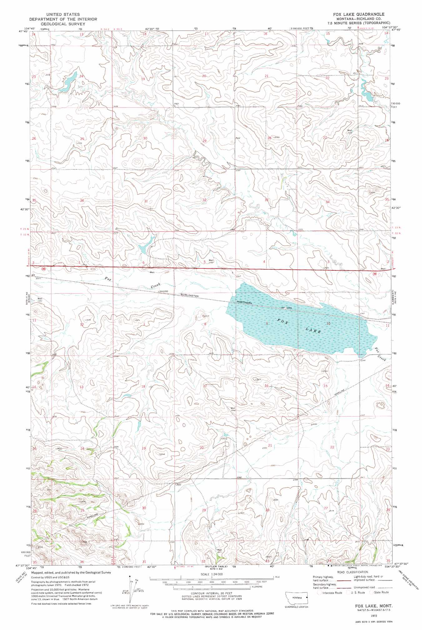
USGS Topo Quad 47104f6 - 1:24,000 scale
| Topo Map Name: | Fox Lake |
| USGS Topo Quad ID: | 47104f6 |
| Print Size: | ca. 21 1/4" wide x 27" high |
| Southeast Coordinates: | 47.625° N latitude / 104.625° W longitude |
| Map Center Coordinates: | 47.6875° N latitude / 104.6875° W longitude |
| U.S. State: | MT |
| Filename: | o47104f6.jpg |
| Download Map JPG Image: | Fox Lake topo map 1:24,000 scale |
| Map Type: | Topographic |
| Topo Series: | 7.5´ |
| Map Scale: | 1:24,000 |
| Source of Map Images: | United States Geological Survey (USGS) |
| Alternate Map Versions: |
Fox Lake MT 1972, updated 1975 Download PDF Buy paper map Fox Lake MT 2011 Download PDF Buy paper map Fox Lake MT 2014 Download PDF Buy paper map |
1:24,000 Topo Quads surrounding Fox Lake
Elmdale Nw |
Elmdale |
Elm Coulee |
Andes |
Blue Hill |
Elmdale Sw |
Carda Coulee |
Three Buttes Creek West |
Three Buttes Creek East |
Girard |
Kuester Lake |
Enid |
Fox Lake |
Lambert |
Crane Nw |
Clay Butte |
Enid Se |
Butler Table |
Mccone Heights |
Larson School |
Bloomfield |
Red Top |
Intake Nw |
Allard Ranch |
Knife River Mine |
> Back to 47104e1 at 1:100,000 scale
> Back to 47104a1 at 1:250,000 scale
> Back to U.S. Topo Maps home
Fox Lake topo map: Gazetteer
Fox Lake: Dams
Burke Dam elevation 782m 2565′Tri-W-Inc Number 2 Dam elevation 779m 2555′
Fox Lake: Lakes
Fox Lake elevation 715m 2345′Fox Lake: Parks
Fox Lake Wildlife Management Area elevation 715m 2345′Fox Lake: Streams
Middle Fork Fox Creek elevation 715m 2345′Fox Lake: Wells
22N55E07ABCD01 Well elevation 731m 2398′22N55E32ABDB01 Well elevation 758m 2486′
22N58E09BABB01 Well elevation 736m 2414′
22N59E15DCBC01 Well elevation 717m 2352′
23N54E20BCDD01 Well elevation 777m 2549′
23N55E33AACD01 Well elevation 742m 2434′
Fox Lake digital topo map on disk
Buy this Fox Lake topo map showing relief, roads, GPS coordinates and other geographical features, as a high-resolution digital map file on DVD:
Eastern Montana & Western North Dakota
Buy digital topo maps: Eastern Montana & Western North Dakota