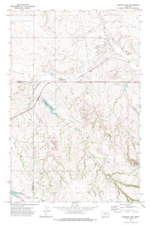
Kuester Lake Topo Map Montana
To zoom in, hover over the map of Kuester Lake
USGS Topo Quad 47104f8 - 1:24,000 scale
| Topo Map Name: | Kuester Lake |
| USGS Topo Quad ID: | 47104f8 |
| Print Size: | ca. 21 1/4" wide x 27" high |
| Southeast Coordinates: | 47.625° N latitude / 104.875° W longitude |
| Map Center Coordinates: | 47.6875° N latitude / 104.9375° W longitude |
| U.S. State: | MT |
| Filename: | o47104f8.jpg |
| Download Map JPG Image: | Kuester Lake topo map 1:24,000 scale |
| Map Type: | Topographic |
| Topo Series: | 7.5´ |
| Map Scale: | 1:24,000 |
| Source of Map Images: | United States Geological Survey (USGS) |
| Alternate Map Versions: |
Kuester Lake MT 1972, updated 1975 Download PDF Buy paper map Kuester Lake MT 2011 Download PDF Buy paper map Kuester Lake MT 2014 Download PDF Buy paper map |
1:24,000 Topo Quads surrounding Kuester Lake
> Back to 47104e1 at 1:100,000 scale
> Back to 47104a1 at 1:250,000 scale
> Back to U.S. Topo Maps home
Kuester Lake topo map: Gazetteer
Kuester Lake: Dams
Bank Dam elevation 738m 2421′Clem Dam elevation 789m 2588′
J Deckert Number 1 Dam elevation 763m 2503′
Kuester Dam elevation 731m 2398′
Yodeling Valley Dam elevation 743m 2437′
Kuester Lake: Reservoirs
Kuester Lake elevation 731m 2398′Kuester Lake: Wells
22N52E01BDBD01 Well elevation 766m 2513′22N52E24DADD01 Well elevation 814m 2670′
22N52E25CBCA01 Well elevation 768m 2519′
22N53E05CDAA01 Well elevation 757m 2483′
22N53E10ABBD01 Well elevation 758m 2486′
22N53E16ACCC01 Well elevation 768m 2519′
22N53E18BCAB01 Well elevation 754m 2473′
22N53E22BDCB01 Well elevation 788m 2585′
22N53E23ABBD01 Well elevation 770m 2526′
22N53E26BAAA01 Well elevation 816m 2677′
22N53E29BDBD01 Well elevation 792m 2598′
22N53E30ABBB01 Well elevation 773m 2536′
23N52E24BCBB01 Well elevation 734m 2408′
23N53E26CAAC01 Well elevation 707m 2319′
23N53E27BBDA01 Well elevation 704m 2309′
23N53E27BBDB01 Well elevation 712m 2335′
23N53E28BABB01 Well elevation 725m 2378′
23N53E30DCAA01 Well elevation 763m 2503′
23N53E31ABCA01 Well elevation 784m 2572′
23N53E32CCBD01 Well elevation 725m 2378′
Kuester Lake digital topo map on disk
Buy this Kuester Lake topo map showing relief, roads, GPS coordinates and other geographical features, as a high-resolution digital map file on DVD:
Eastern Montana & Western North Dakota
Buy digital topo maps: Eastern Montana & Western North Dakota


