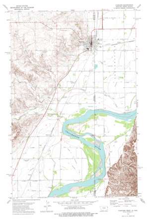
Fairview Topo Map Montana
To zoom in, hover over the map of Fairview
USGS Topo Quad 47104g1 - 1:24,000 scale
| Topo Map Name: | Fairview |
| USGS Topo Quad ID: | 47104g1 |
| Print Size: | ca. 21 1/4" wide x 27" high |
| Southeast Coordinates: | 47.75° N latitude / 104° W longitude |
| Map Center Coordinates: | 47.8125° N latitude / 104.0625° W longitude |
| U.S. States: | MT, ND |
| Filename: | o47104g1.jpg |
| Download Map JPG Image: | Fairview topo map 1:24,000 scale |
| Map Type: | Topographic |
| Topo Series: | 7.5´ |
| Map Scale: | 1:24,000 |
| Source of Map Images: | United States Geological Survey (USGS) |
| Alternate Map Versions: |
Fairview MT 1972, updated 1975 Download PDF Buy paper map Fairview MT 1997, updated 2001 Download PDF Buy paper map Fairview MT 2011 Download PDF Buy paper map Fairview MT 2014 Download PDF Buy paper map |
| FStopo: | US Forest Service topo Fairview is available: Download FStopo PDF Download FStopo TIF |
1:24,000 Topo Quads surrounding Fairview
> Back to 47104e1 at 1:100,000 scale
> Back to 47104a1 at 1:250,000 scale
> Back to U.S. Topo Maps home
Fairview topo map: Gazetteer
Fairview: Airports
Fairview Airport elevation 651m 2135′Fairview: Canals
Lateral G elevation 577m 1893′Lateral G elevation 585m 1919′
Lateral H elevation 578m 1896′
Lateral H elevation 576m 1889′
Lateral K elevation 575m 1886′
Lateral K elevation 584m 1916′
Lateral L elevation 582m 1909′
Lateral L elevation 578m 1896′
Lateral M elevation 577m 1893′
Lateral N elevation 578m 1896′
Nineteen hundred and three Lateral N elevation 586m 1922′
Fairview: Parks
Old Fort Gilbert Historical Marker elevation 591m 1938′Richland Park elevation 579m 1899′
Sharbano Park elevation 583m 1912′
Fairview: Populated Places
East Fairview elevation 580m 1902′Fairview elevation 583m 1912′
Harding elevation 578m 1896′
Ludington elevation 583m 1912′
Ridgelawn elevation 583m 1912′
Wooley elevation 586m 1922′
Fairview: Post Offices
Fairview Post Office elevation 583m 1912′Ridgelawn Post Office (historical) elevation 583m 1912′
Fairview: Streams
Cheney Creek elevation 574m 1883′Cheney Creek elevation 574m 1883′
First Hay Creek elevation 574m 1883′
Second Hay Creek elevation 577m 1893′
Third Hay Creek elevation 577m 1893′
Fairview: Trails
Lewis and Clark Trail elevation 584m 1916′Fairview: Wells
23N59E01AB__01 Well elevation 583m 1912′23N59E01BA__01 Well elevation 583m 1912′
23N59E01BC__01 Well elevation 583m 1912′
23N59E01CC__01 Well elevation 583m 1912′
23N59E01DC__01 Well elevation 579m 1899′
23N59E02AB__01 Well elevation 591m 1938′
23N59E02CA__01 Well elevation 587m 1925′
23N59E02CC__01 Well elevation 587m 1925′
23N59E02DB__01 Well elevation 585m 1919′
23N59E02DD__01 Well elevation 583m 1912′
23N59E02DD__02 Well elevation 583m 1912′
23N59E11AA__01 Well elevation 583m 1912′
23N59E11AA__02 Well elevation 583m 1912′
23N59E11AB__01 Well elevation 583m 1912′
23N59E11BA__01 Well elevation 585m 1919′
23N59E11BA__02 Well elevation 585m 1919′
23N59E11CC__01 Well elevation 584m 1916′
23N59E11CD__01 Well elevation 585m 1919′
23N59E12AC__01 Well elevation 580m 1902′
23N59E12DA__01 Well elevation 578m 1896′
23N59E12DA__02 Well elevation 578m 1896′
23N59E13AA__01 Well elevation 578m 1896′
23N59E13BA__01 Well elevation 584m 1916′
23N59E13BC__01 Well elevation 584m 1916′
23N59E14AA__01 Well elevation 584m 1916′
23N59E14AB__01 Well elevation 584m 1916′
23N59E14DA__01 Well elevation 585m 1919′
23N60E06CA__01 Well elevation 578m 1896′
23N60E06CD__01 Well elevation 578m 1896′
23N60E06DC__01 Well elevation 578m 1896′
23N60E07AD__01 Well elevation 577m 1893′
23N60E07CD__01 Well elevation 577m 1893′
23N60E08BC__01 Well elevation 577m 1893′
23N60E18AA__01 Well elevation 573m 1879′
23N60E18BB__01 Well elevation 577m 1893′
24N59E03DDDD01 Well elevation 652m 2139′
24N60E07BA__01 Well elevation 654m 2145′
24N60E18AACA01 Well elevation 595m 1952′
24N60E19BAC_01 Well elevation 596m 1955′
Fairview digital topo map on disk
Buy this Fairview topo map showing relief, roads, GPS coordinates and other geographical features, as a high-resolution digital map file on DVD:
Eastern Montana & Western North Dakota
Buy digital topo maps: Eastern Montana & Western North Dakota


