Elmdale Sw Topo Map Montana
To zoom in, hover over the map of Elmdale Sw
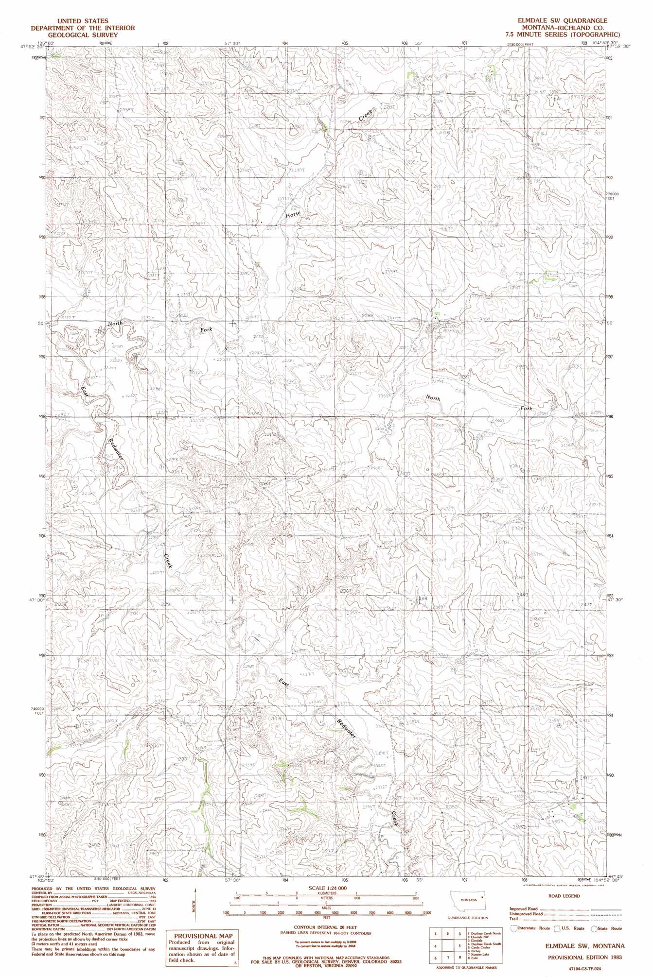
USGS Topo Quad 47104g8 - 1:24,000 scale
| Topo Map Name: | Elmdale Sw |
| USGS Topo Quad ID: | 47104g8 |
| Print Size: | ca. 21 1/4" wide x 27" high |
| Southeast Coordinates: | 47.75° N latitude / 104.875° W longitude |
| Map Center Coordinates: | 47.8125° N latitude / 104.9375° W longitude |
| U.S. State: | MT |
| Filename: | o47104g8.jpg |
| Download Map JPG Image: | Elmdale Sw topo map 1:24,000 scale |
| Map Type: | Topographic |
| Topo Series: | 7.5´ |
| Map Scale: | 1:24,000 |
| Source of Map Images: | United States Geological Survey (USGS) |
| Alternate Map Versions: |
Elmdale SW MT 1983, updated 1983 Download PDF Buy paper map Elmdale SW MT 2011 Download PDF Buy paper map Elmdale SW MT 2014 Download PDF Buy paper map |
1:24,000 Topo Quads surrounding Elmdale Sw
Poplar |
Sprole |
Mortarstone Bluff |
Frog Coulee |
Twomile Creek |
Sullivan Coulee |
Duplisse Creek North |
Elmdale Nw |
Elmdale |
Elm Coulee |
Lisk Creek |
Duplisse Creek South |
Elmdale Sw |
Carda Coulee |
Three Buttes Creek West |
Richey Nw |
Richey |
Kuester Lake |
Enid |
Fox Lake |
Circle Reservoir |
Richey Se |
Clay Butte |
Enid Se |
Butler Table |
> Back to 47104e1 at 1:100,000 scale
> Back to 47104a1 at 1:250,000 scale
> Back to U.S. Topo Maps home
Elmdale Sw topo map: Gazetteer
Elmdale Sw: Streams
Horse Creek elevation 682m 2237′North Fork East Redwater Creek elevation 673m 2208′
Elmdale Sw: Wells
23N53E10DDDB01 Well elevation 716m 2349′23N53E14BAAB01 Well elevation 717m 2352′
23N53E14BABD01 Well elevation 721m 2365′
23N53E14BADA01 Well elevation 727m 2385′
23N53E14BADD01 Well elevation 727m 2385′
23N53E14BBAD01 Well elevation 719m 2358′
23N53E14BBDA01 Well elevation 720m 2362′
23N53E18ACCD01 Well elevation 723m 2372′
24N53E09ABBB01 Well elevation 713m 2339′
24N53E14CBAA01 Well elevation 710m 2329′
24N53E14CBAA02 Well elevation 710m 2329′
24N53E14DBBA01 Well elevation 723m 2372′
24N53E15CCCD01 Well elevation 694m 2276′
24N53E33BDAD01 Well elevation 745m 2444′
24N53E34AAAB01 Well elevation 722m 2368′
25N53E32DBBD01 Well elevation 715m 2345′
25N53E32DBCD01 Well elevation 712m 2335′
25N53E32DBCD02 Well elevation 714m 2342′
25N53E33CABA01 Well elevation 745m 2444′
Elmdale Sw digital topo map on disk
Buy this Elmdale Sw topo map showing relief, roads, GPS coordinates and other geographical features, as a high-resolution digital map file on DVD:
Eastern Montana & Western North Dakota
Buy digital topo maps: Eastern Montana & Western North Dakota