Lindsay Sw Topo Map Montana
To zoom in, hover over the map of Lindsay Sw
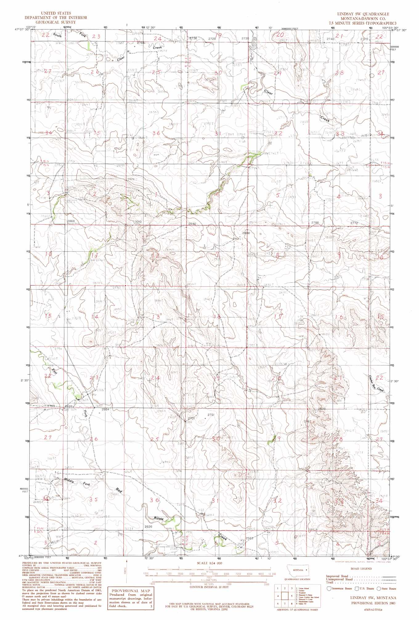
USGS Topo Quad 47105a2 - 1:24,000 scale
| Topo Map Name: | Lindsay Sw |
| USGS Topo Quad ID: | 47105a2 |
| Print Size: | ca. 21 1/4" wide x 27" high |
| Southeast Coordinates: | 47° N latitude / 105.125° W longitude |
| Map Center Coordinates: | 47.0625° N latitude / 105.1875° W longitude |
| U.S. State: | MT |
| Filename: | o47105a2.jpg |
| Download Map JPG Image: | Lindsay Sw topo map 1:24,000 scale |
| Map Type: | Topographic |
| Topo Series: | 7.5´ |
| Map Scale: | 1:24,000 |
| Source of Map Images: | United States Geological Survey (USGS) |
| Alternate Map Versions: |
Lindsay SW MT 1983, updated 1983 Download PDF Buy paper map Lindsay SW MT 2011 Download PDF Buy paper map Lindsay SW MT 2014 Download PDF Buy paper map |
1:24,000 Topo Quads surrounding Lindsay Sw
Mount Antelope |
Olson Coulee South |
Deer Creek Church |
Johnson Reservoir |
Stinking Coulee |
Diamond G Butte Nw |
Union School |
Lindsay |
Woodrow |
Poverty Flat West |
North Coulee |
Diamond G Butte |
Lindsay Sw |
Upper Cracker Box School |
Pleasant View |
Papps Reservoir |
Diamond G Creek |
Hendrickson Coulee |
Fallon Ne |
Marsh |
Calypso |
Terry |
Fallon Sw |
Fallon |
Marsh Sw |
> Back to 47105a1 at 1:100,000 scale
> Back to 47104a1 at 1:250,000 scale
> Back to U.S. Topo Maps home
Lindsay Sw topo map: Gazetteer
Lindsay Sw: Dams
Fleming Dam elevation 820m 2690′Hogmire Reservoir Dam elevation 835m 2739′
Walker Dam elevation 839m 2752′
Walker Number 2 Dam elevation 841m 2759′
Lindsay Sw: Post Offices
Twoee Post Office (historical) elevation 821m 2693′Lindsay Sw: Streams
Cigar Creek elevation 817m 2680′East Fork Bad Route Creek elevation 804m 2637′
South Fork Clear Creek elevation 832m 2729′
Lindsay Sw: Wells
14N52E06AAA_01 Well elevation 789m 2588′15N51E14BBC_01 Well elevation 850m 2788′
15N51E34AAA_01 Well elevation 811m 2660′
16N51E26BAA_01 Well elevation 847m 2778′
16N51E35ABB_01 Well elevation 848m 2782′
16N51E36DCCC01 Well elevation 879m 2883′
16N52E29CBC_01 Well elevation 825m 2706′
16N52E29DBA_01 Well elevation 862m 2828′
Lindsay Sw digital topo map on disk
Buy this Lindsay Sw topo map showing relief, roads, GPS coordinates and other geographical features, as a high-resolution digital map file on DVD:
Eastern Montana & Western North Dakota
Buy digital topo maps: Eastern Montana & Western North Dakota