Diamond G Butte Topo Map Montana
To zoom in, hover over the map of Diamond G Butte
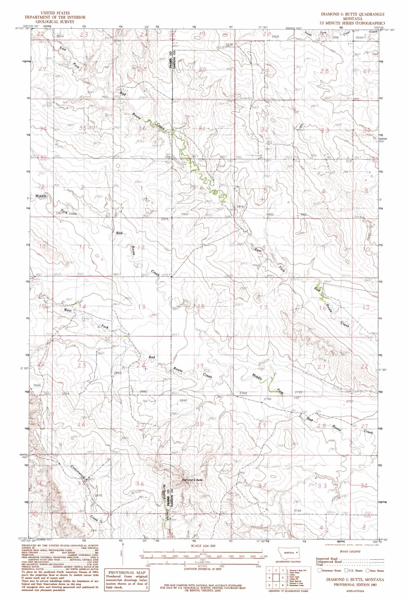
USGS Topo Quad 47105a3 - 1:24,000 scale
| Topo Map Name: | Diamond G Butte |
| USGS Topo Quad ID: | 47105a3 |
| Print Size: | ca. 21 1/4" wide x 27" high |
| Southeast Coordinates: | 47° N latitude / 105.25° W longitude |
| Map Center Coordinates: | 47.0625° N latitude / 105.3125° W longitude |
| U.S. State: | MT |
| Filename: | o47105a3.jpg |
| Download Map JPG Image: | Diamond G Butte topo map 1:24,000 scale |
| Map Type: | Topographic |
| Topo Series: | 7.5´ |
| Map Scale: | 1:24,000 |
| Source of Map Images: | United States Geological Survey (USGS) |
| Alternate Map Versions: |
Diamond G Butte MT 1983, updated 1983 Download PDF Buy paper map Diamond G Butte MT 2011 Download PDF Buy paper map Diamond G Butte MT 2014 Download PDF Buy paper map |
1:24,000 Topo Quads surrounding Diamond G Butte
Quick Reservoir |
Mount Antelope |
Olson Coulee South |
Deer Creek Church |
Johnson Reservoir |
Bearshack Creek |
Diamond G Butte Nw |
Union School |
Lindsay |
Woodrow |
Becker Dam |
North Coulee |
Diamond G Butte |
Lindsay Sw |
Upper Cracker Box School |
Mccloud |
Papps Reservoir |
Diamond G Creek |
Hendrickson Coulee |
Fallon Ne |
Mcclure Reservoir |
Calypso |
Terry |
Fallon Sw |
Fallon |
> Back to 47105a1 at 1:100,000 scale
> Back to 47104a1 at 1:250,000 scale
> Back to U.S. Topo Maps home
Diamond G Butte topo map: Gazetteer
Diamond G Butte: Streams
Middle Fork Bad Route Creek elevation 839m 2752′West Fork Bad Route Creek elevation 839m 2752′
Diamond G Butte: Summits
Diamond G Butte elevation 985m 3231′Diamond G Butte: Wells
15N50E02ABAB01 Well elevation 909m 2982′15N50E14DBAD01 Well elevation 878m 2880′
15N50E25ABAC01 Well elevation 881m 2890′
15N50E26ABDD01 Well elevation 896m 2939′
15N50E35ACCA01 Well elevation 883m 2896′
15N51E06ACC_01 Well elevation 870m 2854′
15N51E08BBD_01 Well elevation 869m 2851′
Diamond G Butte digital topo map on disk
Buy this Diamond G Butte topo map showing relief, roads, GPS coordinates and other geographical features, as a high-resolution digital map file on DVD:
Eastern Montana & Western North Dakota
Buy digital topo maps: Eastern Montana & Western North Dakota