Duplisse Creek North Topo Map Montana
To zoom in, hover over the map of Duplisse Creek North
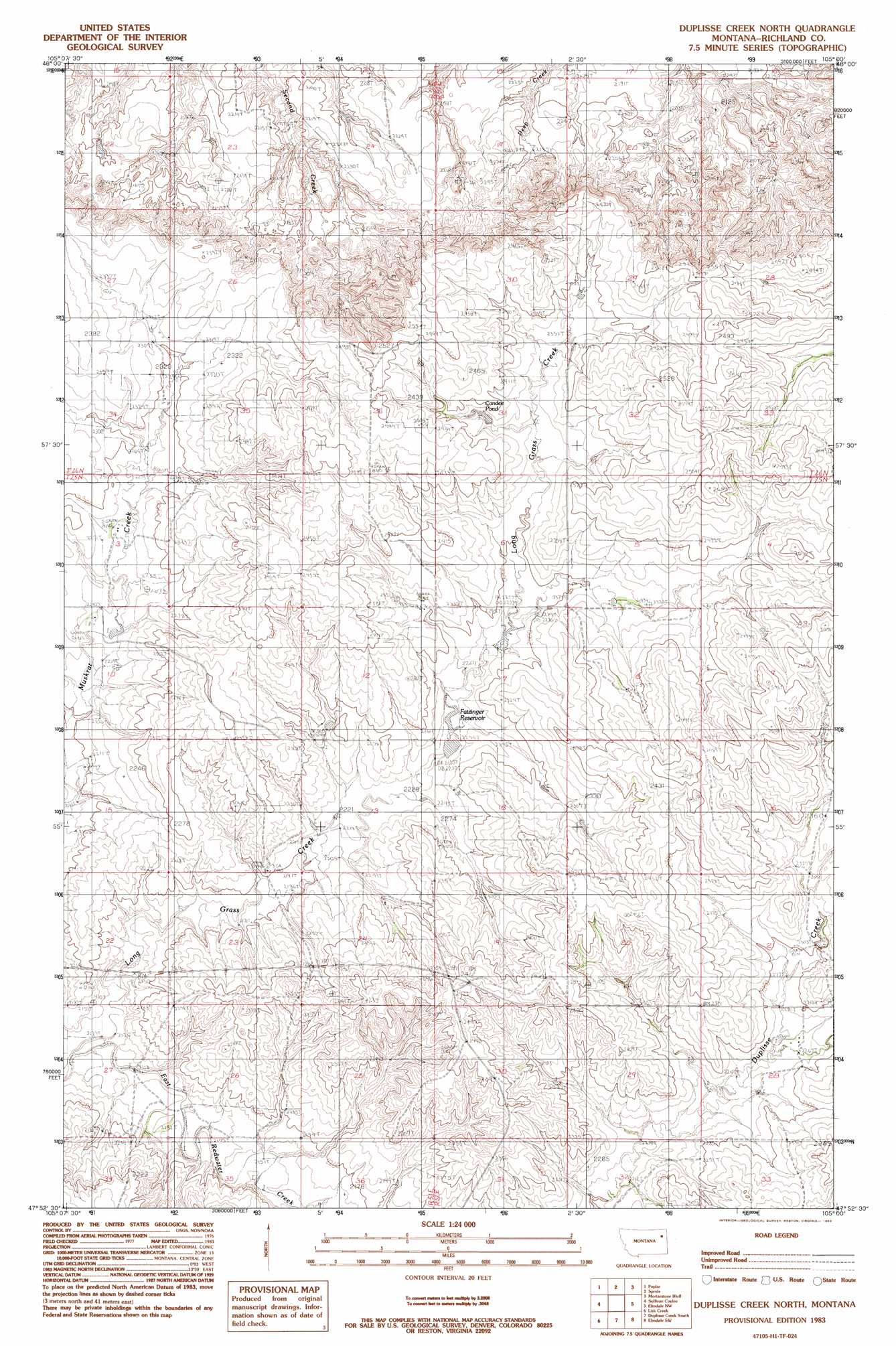
USGS Topo Quad 47105h1 - 1:24,000 scale
| Topo Map Name: | Duplisse Creek North |
| USGS Topo Quad ID: | 47105h1 |
| Print Size: | ca. 21 1/4" wide x 27" high |
| Southeast Coordinates: | 47.875° N latitude / 105° W longitude |
| Map Center Coordinates: | 47.9375° N latitude / 105.0625° W longitude |
| U.S. State: | MT |
| Filename: | o47105h1.jpg |
| Download Map JPG Image: | Duplisse Creek North topo map 1:24,000 scale |
| Map Type: | Topographic |
| Topo Series: | 7.5´ |
| Map Scale: | 1:24,000 |
| Source of Map Images: | United States Geological Survey (USGS) |
| Alternate Map Versions: |
Duplisse Creek North MT 1983, updated 1983 Download PDF Buy paper map Duplisse Creek North MT 2011 Download PDF Buy paper map Duplisse Creek North MT 2014 Download PDF Buy paper map |
1:24,000 Topo Quads surrounding Duplisse Creek North
Chelsea |
Badger Creek |
Poplar Ne |
Brockton |
Calais |
Nickwall |
Poplar |
Sprole |
Mortarstone Bluff |
Frog Coulee |
Dowse Coulee |
Sullivan Coulee |
Duplisse Creek North |
Elmdale Nw |
Elmdale |
Kraut Coulee |
Lisk Creek |
Duplisse Creek South |
Elmdale Sw |
Carda Coulee |
Buffalo Creek Ne |
Richey Nw |
Richey |
Kuester Lake |
Enid |
> Back to 47105e1 at 1:100,000 scale
> Back to 47104a1 at 1:250,000 scale
> Back to U.S. Topo Maps home
Duplisse Creek North topo map: Gazetteer
Duplisse Creek North: Dams
Zinger Number 1 Dam elevation 692m 2270′Duplisse Creek North: Post Offices
Gidley Post Office (historical) elevation 737m 2417′Duplisse Creek North: Reservoirs
Candee Pond elevation 713m 2339′Fatzinger Reservoir elevation 682m 2237′
Duplisse Creek North: Wells
14N53E04CCCA01 Well elevation 661m 2168′25N52E05CCAC01 Well elevation 704m 2309′
25N52E18BCDA01 Well elevation 699m 2293′
25N52E30D___01 Well elevation 709m 2326′
26N51E34ADDD01 Well elevation 698m 2290′
Duplisse Creek North digital topo map on disk
Buy this Duplisse Creek North topo map showing relief, roads, GPS coordinates and other geographical features, as a high-resolution digital map file on DVD:
Eastern Montana & Western North Dakota
Buy digital topo maps: Eastern Montana & Western North Dakota