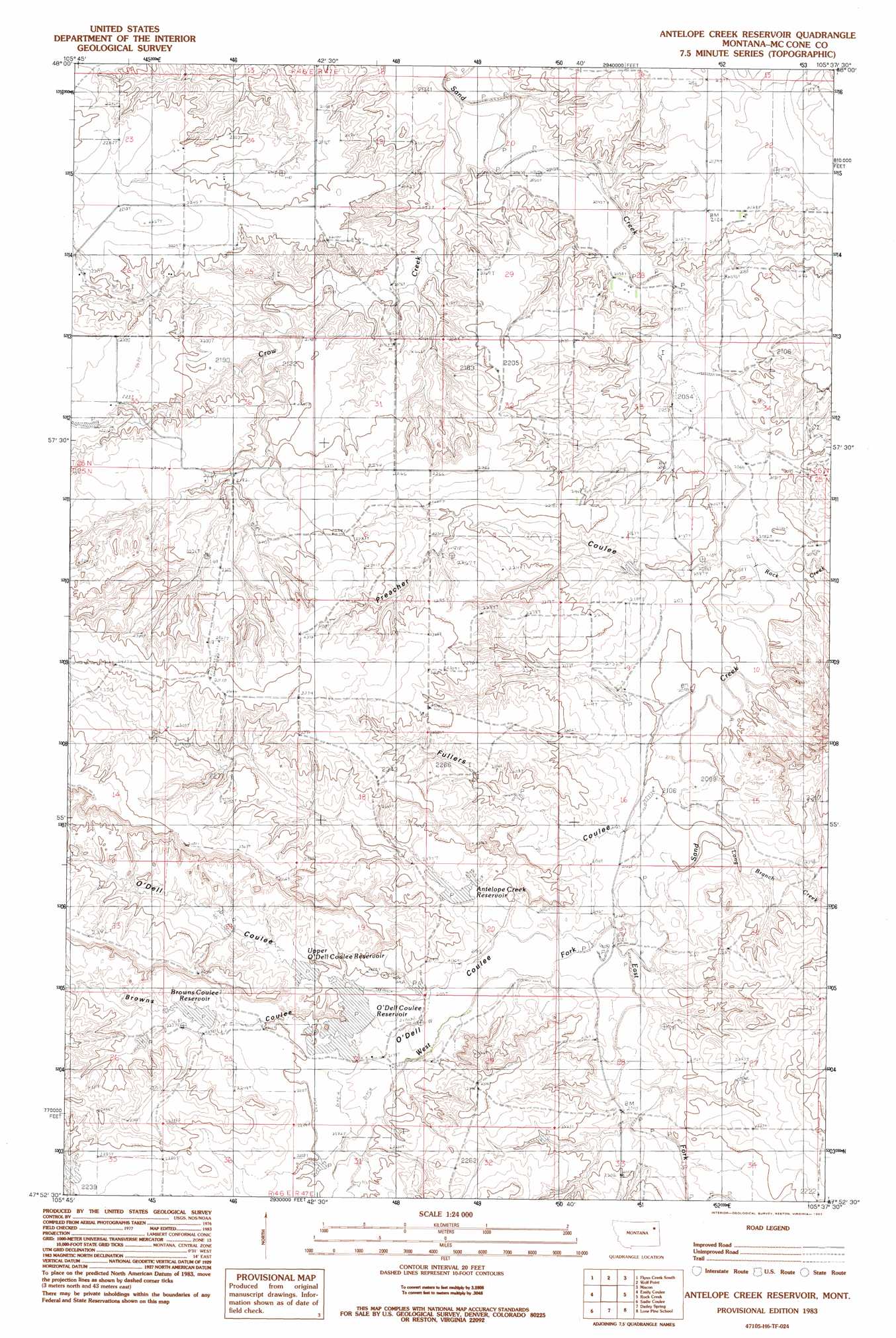
Antelope Creek Res. Topo Map Montana
To zoom in, hover over the map of Antelope Creek Res.
USGS Topo Quad 47105h6 - 1:24,000 scale
| Topo Map Name: | Antelope Creek Res. |
| USGS Topo Quad ID: | 47105h6 |
| Print Size: | ca. 21 1/4" wide x 27" high |
| Southeast Coordinates: | 47.875° N latitude / 105.625° W longitude |
| Map Center Coordinates: | 47.9375° N latitude / 105.6875° W longitude |
| U.S. State: | MT |
| Filename: | o47105h6.jpg |
| Download Map JPG Image: | Antelope Creek Res. topo map 1:24,000 scale |
| Map Type: | Topographic |
| Topo Series: | 7.5´ |
| Map Scale: | 1:24,000 |
| Source of Map Images: | United States Geological Survey (USGS) |
| Alternate Map Versions: |
Antelope Creek Reservoir MT 1983, updated 1983 Download PDF Buy paper map Antelope Creek Reservoir MT 2011 Download PDF Buy paper map Antelope Creek Reservoir MT 2014 Download PDF Buy paper map |
1:24,000 Topo Quads surrounding Antelope Creek Res.
Oswego Nw |
Flynn Creek North |
Wolf Point Nw |
Wolf Point Ne |
Chelsea Nw |
Oswego |
Flynn Creek South |
Wolf Point |
Macon |
Chelsea Sw |
Turtle Creek |
Emily Coulee |
Antelope Creek Res. |
Rock Creek |
Gady Coulee |
Shade Creek |
Sadie Coulee |
Dailey Spring |
Lone Pine School |
Vida |
Figure Eight Creek |
Pedigo Coulee |
Hudiburgh Res. |
Hudiburgh Res. |
Beery Reservoir |
> Back to 47105e1 at 1:100,000 scale
> Back to 47104a1 at 1:250,000 scale
> Back to U.S. Topo Maps home
Antelope Creek Res. topo map: Gazetteer
Antelope Creek Res.: Dams
Ace of Spades Dam elevation 659m 2162′Dealers Choice Dam elevation 667m 2188′
T and S Stock Company Number 3 Dam elevation 708m 2322′
T and S Stock Company Number 4 Dam elevation 679m 2227′
T and S Stock Company Number 5 Dam elevation 669m 2194′
Antelope Creek Res.: Reservoirs
Antelope Creek Reservoir elevation 661m 2168′O'Dell Coulee Reservoir elevation 667m 2188′
Upper O'Dell Coulee Reservoir elevation 671m 2201′
Antelope Creek Res.: Streams
Antelope Creek elevation 652m 2139′Crow Creek elevation 618m 2027′
East Fork Sand Creek elevation 644m 2112′
Long Branch Creek elevation 638m 2093′
Mud Creek elevation 623m 2043′
Rock Creek elevation 629m 2063′
West Fork Sand Creek elevation 646m 2119′
Antelope Creek Res.: Valleys
Browns Coulee elevation 668m 2191′Fullers Coulee elevation 634m 2080′
O'Dell Coulee elevation 654m 2145′
Preacher Coulee elevation 628m 2060′
Antelope Creek Res.: Wells
14N48E08BCCD01 Well elevation 639m 2096′25N46E01DBAA01 Well elevation 683m 2240′
25N46E02BD__01 Well elevation 691m 2267′
25N47E04DAAB01 Well elevation 649m 2129′
25N47E07BBDA01 Well elevation 723m 2372′
25N47E30ACCD01 Well elevation 664m 2178′
26N47E30ACCD01 Well elevation 633m 2076′
Antelope Creek Res. digital topo map on disk
Buy this Antelope Creek Res. topo map showing relief, roads, GPS coordinates and other geographical features, as a high-resolution digital map file on DVD:
Eastern Montana & Western North Dakota
Buy digital topo maps: Eastern Montana & Western North Dakota